- Home
- :
- All Communities
- :
- Industries
- :
- Land Records and Valuation
- :
- Land Records and Valuation Questions
- :
- Re: Parcels with no functionality? When I click on...
- Subscribe to RSS Feed
- Mark Topic as New
- Mark Topic as Read
- Float this Topic for Current User
- Bookmark
- Subscribe
- Mute
- Printer Friendly Page
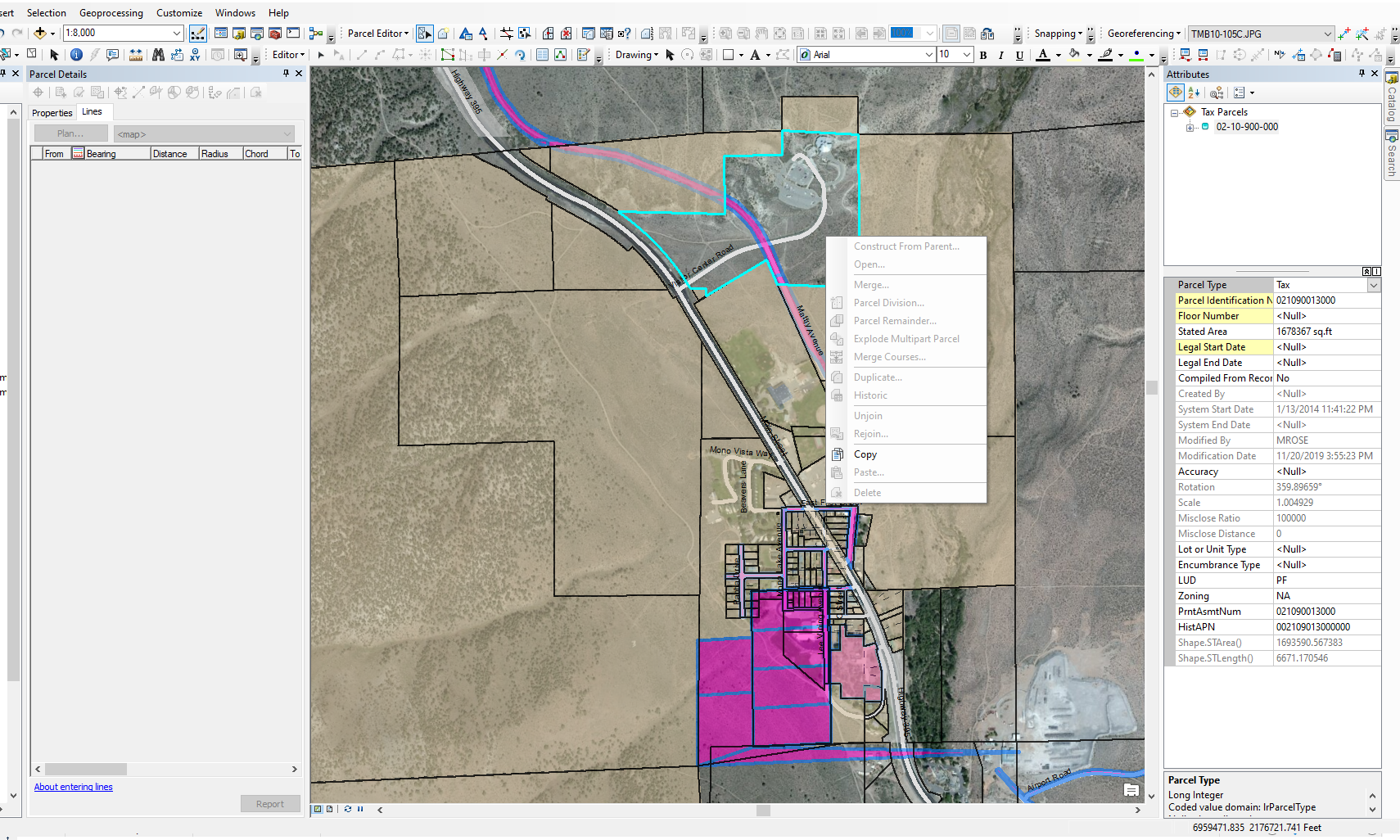
Parcels with no functionality? When I click on a parcel all I can do is copy -- all other options greyed out.
- Mark as New
- Bookmark
- Subscribe
- Mute
- Subscribe to RSS Feed
- Permalink
- Report Inappropriate Content
I am using ArcGIS 10.6 for county-level land record management. I am using the Local Government Model and am working in an area that needs a lot of redrafting / addition of lots, ROWs, etc.
While I am in parcel editor, when I click on many of these parcels they have no functions available. When I right click, every option is greyed out except "Copy" -- I cannot merge, duplicate, construct by parent, delete -- nothing. When clicked on I can see and edit the attributes, but that's about it. What is going on? How can I fix my parcels?
- Mark as New
- Bookmark
- Subscribe
- Mute
- Subscribe to RSS Feed
- Permalink
- Report Inappropriate Content
Please make sure:
1. You are in an editing session (editing toolbar --> Start editing)
2. The selected parcel(s) is associated to a valid plan. You can open the parcel attributes and view the PlanID, then make sure that PlanID exists in the Plan table (as an ObjectID)
- Mark as New
- Bookmark
- Subscribe
- Mute
- Subscribe to RSS Feed
- Permalink
- Report Inappropriate Content
Hi Amir,
Thank you for your quick reply.
How could I check for the PlanID? I don't see any in my attributes and I am unable to open the parcel.

- Mark as New
- Bookmark
- Subscribe
- Mute
- Subscribe to RSS Feed
- Permalink
- Report Inappropriate Content
Hi Amir,
A fellow commenter walked me through how to check / adjust the Plan ID, and that seemed to be the problem. Thank you so much!
- Mark as New
- Bookmark
- Subscribe
- Mute
- Subscribe to RSS Feed
- Permalink
- Report Inappropriate Content
can you see the parcel in the attribute table? i've run into this problem a few times and these are the causes that i can recall:
- there's something wrong with the parcel when it was created and the parcel has no shape.area or shape.len. this has happened to me before when i have complex remainder parcels or parcels where the fabric spontaneously generates a connection line in the new parcels.
- the PlanID doesn't match the surrounding layer's PlanID - i did this by accident once by changing the PlanID manually in the attribute table for a neighborhood through the field calculator to a specific plan and typoing the PlanID.
- Mark as New
- Bookmark
- Subscribe
- Mute
- Subscribe to RSS Feed
- Permalink
- Report Inappropriate Content
Hi Anna,
I can see the attribute table, and the parcel does have a shape.STarea() and shape.STlength() (see below).
Someone else mentioned the plan...but I don't see a PlanID in my attribute table and am unable to open the parcel.

- Mark as New
- Bookmark
- Subscribe
- Mute
- Subscribe to RSS Feed
- Permalink
- Report Inappropriate Content
to see the PlanID:
- open the attributes table from your table of contents window
- click on "table options" in the upper-left corner
- select "turn all fields on"
you should be able to see the PlanID field after that. it's easier to select your problem parcel and a couple of other properly responding parcels adjacent to (preferably ones abutting the problem parcel) and then using the "show selected records" option on the attribute table to narrow down what you're looking at.
if all of those PlanIDs match, something else is wrong.
i've done this before in the past to figure out what the heck is wrong with my parcels before as well:
in the catalog:
- navigate to your parcel fabric
- expand the tree so you can see all of the individual points, lines, polygons (etc etc) feature classes that make up your parcel fabric
- add the polygon feature class to your display and navigate to where your problem parcel is
- select that polygon.
- inspect it carefully in relation to other surrounding properly responding parcels.
- Mark as New
- Bookmark
- Subscribe
- Mute
- Subscribe to RSS Feed
- Permalink
- Report Inappropriate Content
Hi Anna,
I did as you said - selected four parcels (two properly working and two not working). The two working ones have plans 1 and 276; the two nonworking ones have the same plan of 1493. I don't know what the numbers correspond to but I will try changing them.
(Is there a way to tell what these plan numbers mean? I'm still pretty new to the Local Government model and haven't worked with Plans before).
This is helpful so far, thank you!
- Mark as New
- Bookmark
- Subscribe
- Mute
- Subscribe to RSS Feed
- Permalink
- Report Inappropriate Content
Hi Anna (again)
Editing the Plan ID to match one of the working parcel Plan IDs worked! This has been bugging me for weeks - THANK YOU!
(I still don't understand why...but I'll figure that out next  )
)
- Mark as New
- Bookmark
- Subscribe
- Mute
- Subscribe to RSS Feed
- Permalink
- Report Inappropriate Content
the plans correspond to a table in the parcel fabric where you can store record information. i use it to store subdivision and plat recording numbers, dates, notes about surveys, bizarre problems, just helpful information for the future.
if you're not the only person working on your parcel fabric, it could have been changed that way. if the parcels were imported from another parcel fabric, it might have retained the old PlanID that doesn't correspond to anything on your table.
like i maintain a "scratch" fabric to sketch out subdivisions and surveys. it's a stop-gap solution to help me really visualize where everything goes without affecting my production data. i'll import those parcels using the save as XML/append file options in the parcel editor menu. if that's a workflow that ya'll use it could have easily occurred there.