- Home
- :
- All Communities
- :
- Services
- :
- Implementing ArcGIS
- :
- Implementing ArcGIS Questions
- :
- Re: New and Old ArcMap Problems
- Subscribe to RSS Feed
- Mark Topic as New
- Mark Topic as Read
- Float this Topic for Current User
- Bookmark
- Subscribe
- Mute
- Printer Friendly Page
New and Old ArcMap Problems
- Mark as New
- Bookmark
- Subscribe
- Mute
- Subscribe to RSS Feed
- Permalink
- Report Inappropriate Content
This Articles' only purpose is to bash ArcMap for several Problems, some of them old, some of them new.
Administrators feel free to put this anywhere it should be - I have no time to visit those thousands of themes and communities and whatever. You may put it in the trash, I don't care, I will repost. If any problem I mention here got a solution in 10.7., take it simply as not mentioned 😉
1st Problem: This "GeoNet" is now existing for a while and it seems to be existing in this hardly comprehensible structure just as a hindrance to post proper comments on proper places. If one can live in it and with it, fine. But I see it as a method to reduce complaints. As I am at work, I cannot spend hours to explore this community. I have to be fast and efficient.
2nd Problem: Old. ArcMap (I am on 10.6.1) did not allow certain lengths of filenames, certain characters in filenames, each level and kind of allowance seems to be different with the team that created the respective tool. It should now, since ArcMap "has been rewritten in Version 10", for all tools be the same, and all tools should be able to overwrite files that are at least not in use. Since we aren't such idiots that aren't able to honor a warning. But ArcMap quite resists those hopes.
3rd problem: Newer: ArcMap began to become slow in 10.4. but now in 10.6. it is very slow. I do not talk about the Font problem in dialogs, beginning with 10.4 or 10.5 (which needed complaints by many users, many useless tips, and many months until it was solved after the release of 10.6). Meanwhile, someone decided to give multiple TOC redraws, together with multiple feature redraws a try. Why not making a GIS slower if it isn't already slow enough ?
4th problem: Older: I don't know when ArcMap began to confirm a successful execution of a geoprocessing tool, but didn't execute anything. I think it was in 10.3 or 10.4. You start a tool, it executes successfully, and if you search for a resulting change (i.e. a new shapefile or so), you find nothing. Great idea, folks ! I like to be pranked professionally ! To save Esris' honor, after a restart/reload of the map or ArcMap, this may (or may not) work (simply recall the procedure from history).
5th problem: Older. When I open a tool, say 3d-Analysts' "Add Surface Information", I select the Input feature Class and the Input Surface. If one of those features is in a group (as 99.9 percent of my feature classes are) , the execution of the tool could fail (if it doesn't show a successful execution where it didn't do anything, see 4th problem). I have to locate the features with their correct paths then, in order to hope for a successfull execution. To restart the map or ArcMap itself usually doesn't help here .
6th problem: Old: The positioning of TOC, Toolbox, and other bigger elements is a pain with those Auto-Snap-Placers appearing immediately. Could not anyone invent an easier method helping with that monsters layout ? And to save the complete layout, as it tooks time to configure it, and after a fresh installation, it is gone.
7th problem: Old: It happens so often that you need to overwrite or simply, for instance, change a shapefile. Now, it is understandable that there are certain problems with changing files while they are in use. So one may think, let's remove the file from TOC, and then overwrite or change it. But no, that doesn't work. ArcMap leaves all kind of file locks (some of them magically inside an excel file !) until ArcMap is shut down. Yes, it isn't enough to open a new Map, some file locks survive even that.
8th problem: Old: ArcMap has great functionality and great sense for styling, but the problem with sometimes eight or more levels of click-through (f.i. Properties / Labels / Symbol / Edit symbol / Advanced Text / Text Background Properties / Balloon Callout Symbol / Edit Symbol Line Fill Symbol Line / Edit Symbol / Cartographic Line Decorations Properties / Line Decoration Symbol / Edit Symbol / Arrow Marker Symbol Mask Symbol / Edit Symbol / Marker Fill Symbol Marker / Edit Symbol / Mask Symbol / Edit Symbol / ...... 18th Level that was) is waiting for a horizontal short-cut for years now.
9th problem: Old: No .bak files of any kind.
10th problem: Old: Pdf-Transparency !! Yes, transpacency in pdf exists for a very long time now. But Arcmap renders every feature that got a transparency as a raster, and every feature under this, also. That leads to huge pdf's, when vector content has to be shown properly and therefore the raster resulution needs to be enhanced. Many users aren't aware of that, and many are wondering why a small map results in a huge pdf. There is even a catch: If ArcMap decides that the map is complex, rasterization can affect even "higher" (in terms of z-order) placed layers. Then we have to create a vector group, and a raster group, where both types are completely separeted from each other. But why isn't there a pdf-transparency option ? Boys and Girls, yes, it IS possible.
11th problem: Old: At some point of complexity, both Maplex and the Standard label engine are giving up their good work. You then can create levels and rules, it doesn't matter. Labels are drawn....not following the rules anymore. As if Maplex is lying on the ground and says to us, please...I am done....But however !! It leads us to the
12th problem: Old: Why can't I simply place manually the labels I need to place manually ? Why do I have to create a Annotation Feature Class, and why, oh why is it so complicated to change its reference scale afterwards ? Why is the bounding box of individual overriden Lables in an AFC changing, or better aske, why isn't the bounding box, where the label shows up, anymore ? (I know it, but the explanation is kind of rude).
13th problem: Newer: Performance again. ArcMap seems not to take advantage of CAD graphics cards. But ArcMap also seems to become slower and slower (taking minutes for start, with or without loading maps), with growing lag after opening tools, and the tendency is disturbing. We have several Dell Precisions here with Xeon1545 and 32 GB RAM, and it seems that ArcMap gets faster slow than the hardware can evolve. That wasn't alwas alike, as I remember (I began with 8.0).
- Mark as New
- Bookmark
- Subscribe
- Mute
- Subscribe to RSS Feed
- Permalink
- Report Inappropriate Content
I guess you could use MapInfo instead....
- Mark as New
- Bookmark
- Subscribe
- Mute
- Subscribe to RSS Feed
- Permalink
- Report Inappropriate Content
No I cannot. The company I work for provides ArcMap, and Qgis. MapInfo is not an option. If it were, I wouldn't have spent time to write this.
- Mark as New
- Bookmark
- Subscribe
- Mute
- Subscribe to RSS Feed
- Permalink
- Report Inappropriate Content
To put this whole article online I had to find a place for it. Now that is the point where all the fun is lost, because I feel my self as too dumb to find the right "place" for a comment like this, by endlessly cycling through the four option lists (Following, Spaces,Groups and Projects) - but wait, not endlessly ! "Groups" ends with "Gis for Hydrographic Surveying". Really ? All Groups end with one Group of the letter "G" ? (FF 68.0.1/32 Bit). In fact, I find myself too dumb to place any comment. There is no place "ArcGis Desktop" in any list (But "ArcGis Pro" there is). There is no "ArcGis Desktop Users" Group, no "Arcgis Desktop Problems" and so on. But, there are (for me) complete meaningless and uninteresting (and obviously abandoned) groups and places like "ArcGis Urban", or "Ghost Avengers", they could also be called 'Insignificant Group with one or two followers'.
To be serious: A forum for a software like this has to be self-explanatory, not on a own level of difficulty and complexity. Most of the hundreds of forums I ever encountered during the last 30 years didn't need one line of explanation where and how I had to place a comment, since they had and have a simple but effective tree structure. So I feel validated for having a sufficient IQ to contribute something. In this "community" I do not feel this. But I had no problem with its predecessor.
- Mark as New
- Bookmark
- Subscribe
- Mute
- Subscribe to RSS Feed
- Permalink
- Report Inappropriate Content
Hi Oskar - First off, I'm sorry to hear that you haven't had the greatest experience on GeoNet. But I do thank you for sharing your honest feedback on your GeoNet experience. I wanted to respond back to a couple of your points...
First, I wanted to let you know that we have heard similar feedback about the difficulties of navigating GeoNet and we are talking steps to improve the experience. We're in regular conversation with our GeoNet MVPs, Esri Staff and other members to help us make improvements on the current platform and help create a list of requirements for future enhancement, such as this one going on about ArcGIS Ideas. Yes, the goal is to make the community experience as intuitive as possible and we hope by working with you and other members we can make it easier to connect and collaborate. In the meantime, in case you've haven't seen them, I invite you to check out this collection of guides in the GeoNet Resource Hub that you can use.
Secondly, yes, there are a lot of "dead and in-active" places on GeoNet and to address this we did an audit of the GeoNet places last year, and we will be completing the audit with a clean up and deletion of in-active spaces in the near future. Hopefully that audit will make it easier to find and participate in GeoNet group and spaces.
As always, we love to have open conversations like this about your GeoNet experience and we want to hear what's working and what's not, so we can improve. I welcome your further feedback and let us know if you'd like to be involved in future GeoNet feedback sessions.
Thanks,
Chris
- Mark as New
- Bookmark
- Subscribe
- Mute
- Subscribe to RSS Feed
- Permalink
- Report Inappropriate Content
Hello Christopher, thank you for your kind words. I didn't expect them. At least someone is watching.
My simple solution, although I believe it wouldn't be considered by Esri, is, to go back (at least partially) to the old forum.
Or, create a simple structure that on first level honors GIS themes, tasks solutions, on the secon level ESRI products hoizontally, then vertically. I would like to click only four, five, maybe six times before I put my main comment from above as a "new thread" into the thread-stream..
The shortcoming of that structure is clear, by the way. Problems would easily drown in the stream of other questions, threads like mine would be dead quickly, if the stream would be too broad and fast.
- Mark as New
- Bookmark
- Subscribe
- Mute
- Subscribe to RSS Feed
- Permalink
- Report Inappropriate Content
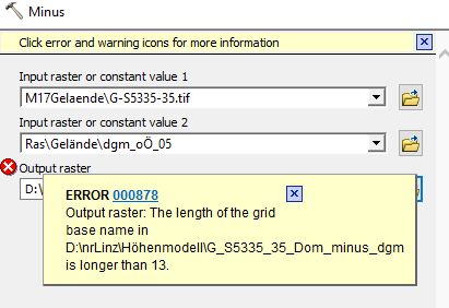
The following picture shows an error in the 3d Analyst "Minus" function. It needs filenames that aren't longer than 13 chars. Sometimes I like those survivors from the nineties. And from different operation systems, because I don't remember Windows struggling with that filename length.
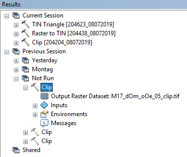
In the next image another one of my complaints is documented:
Operations that weren't executed, are remembered in the results, after a restart of Arcmap.
If started again from the results history, the operations are executed properly.
This one had cost me only about ten minutes, executing three times without success, shutting down, restarting, and re-executing. Luckily I already suspected the failure and did not spend long with variations.
But ArcMap confirmed falsly their succeed in execution after every attempt.
- Mark as New
- Bookmark
- Subscribe
- Mute
- Subscribe to RSS Feed
- Permalink
- Report Inappropriate Content
You could always use ArcGIS Pro instead.....
- Mark as New
- Bookmark
- Subscribe
- Mute
- Subscribe to RSS Feed
- Permalink
- Report Inappropriate Content
Hi Michael, thank you for your input. In fact, the answer I had in mind before was not very amicable. But I have to answer kindly, because otherwise I may get the axe.
So, what I basically say to your suggestion, is, No, we cannot always use ArcGis Pro instead. The reasons for that are out there for you to find with a proper search engine, but in a nutshell, ArcMap Pro is, in its current state, not to be considerered as a replacement for ArcMap plus 3dAnalyst plus Spatial Analyst, in the company of my employer.
Since we have a lot of ongoing projects, a transition from ArcMap to Pro would be not a wise decision. Until it would be, we stay with ArcMap.