- Home
- :
- All Communities
- :
- Services
- :
- Implementing ArcGIS
- :
- Implementing ArcGIS Blog
- :
- Distributed GIS - Establishing a Trusted Collabora...
Distributed GIS - Establishing a Trusted Collaboration
- Subscribe to RSS Feed
- Mark as New
- Mark as Read
- Bookmark
- Subscribe
- Printer Friendly Page
- Report Inappropriate Content
A Distributed GIS is a modern approach that supports a new type of sharing. With distributed GIS, multiple GIS deployments are connected with each other, and users can use web maps and apps to easily create, manage, analyze, publishing and share geospatial content. This integrated approach preserves control and access with individual departments while supporting the broader business needs of the organization. The result is a truly collaborate environment – an integrated set of deployments working together towards shared goals.
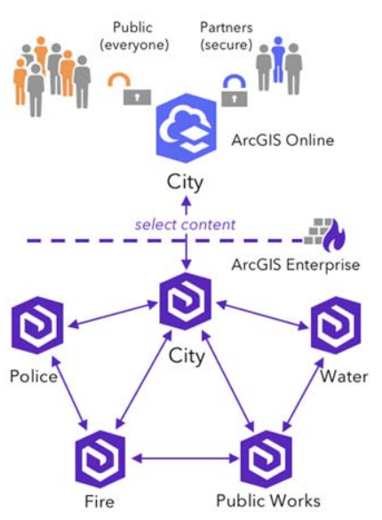
Trusted Collaboration
To create a distributed GIS, you simply connect multiple Web GIS environments that can include multiple ArcGIS Enterprise deployments as well as an ArcGIS Online organization. We call these connections “trusted collaborations”. You can configure a trusted collaboration between deployments using the out-of-the-box capabilities of ArcGIS which let you easily define how data is shared. No custom coding required.
Trusted collaborations between deployments are secure, using your deployments existing security model. Users can share data – either as a copy or as a reference to the sources (requiring authentication) – to other collaboration participants. Collaboration creates a network where multiple systems can access data and information products from their own environment, keeping authoritative sources intact, with updates either in real time or at scheduled intervals.
Is it for me?
Distributed GIS will be of interest to a wide variety of organizations and departments including those with a purpose to maintain or manage data and provide it to other business units or audiences, who have faced challenges getting authoritative data to target audiences effectively and efficiently, and those that create data in one environments (i.e. ArcGIS Enterprise) and host it for customers in another (i.e. ArcGIS Online).
Develop a Strategy
A distributed GIS is an integrated set of GIS deployments working together and sharing content as part of a trusted collaboration. Implementing a distributed GIS is an effective way to leverage authoritative data, foster communication and engagement across user types, and glean insights from data to generate powerful location intelligence. A distributed GIS also preserves departmental control over data and workflows while contributing to and supporting the needs of the enterprise.
Download the presentation from the 2018 Esri User’s Conference: Distributed GIS – Establishing a Trusted Collaboration to take a closer look and begin to develop your strategy.
Architecting the ArcGIS Platform: Best Practices
This blog post, serves as a high-level introduction to one topic that is featured in the Architecting the ArcGIS Platform: Best Practices whitepaper published by Esri. Other topics include High Availability, Load Balancing, Security, and more. Please click on the link above to learn more or post comments to ask questions and engage with Esri staff.
You must be a registered user to add a comment. If you've already registered, sign in. Otherwise, register and sign in.