- Home
- :
- All Communities
- :
- Products
- :
- Imagery and Remote Sensing
- :
- Imagery Questions
- :
- Re: Why am I seeing alignment issues between ArcOn...
- Subscribe to RSS Feed
- Mark Topic as New
- Mark Topic as Read
- Float this Topic for Current User
- Bookmark
- Subscribe
- Mute
- Printer Friendly Page
Why am I seeing alignment issues between ArcOnline Landsat and World Imagery?
- Mark as New
- Bookmark
- Subscribe
- Mute
- Subscribe to RSS Feed
- Permalink
- Report Inappropriate Content
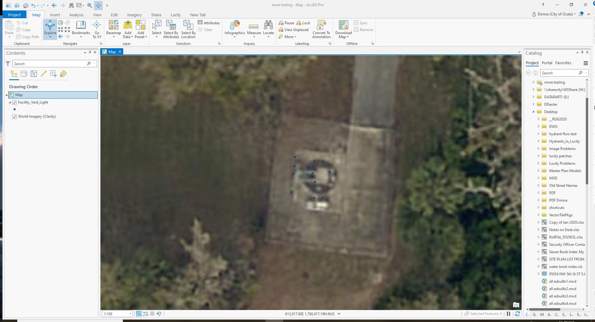
I am wondering why I am seeing alignment issues with Landsat 8 Pansharpened and World Imagery, both layers added from ArcGIS directly from within ArcMap (10.5). Below are screenshots of my issue. The polygon is just a digitized forest boundary. You can see how the boundary makes sense when viewing the World Imagery, but it's misaligned when viewing the same polygon with the Landsat underneath.
Below are the Source Properties from both layers. As far as I can tell they are the same. I made no adjustments to anything after they were added from Arc, as far as I am aware.
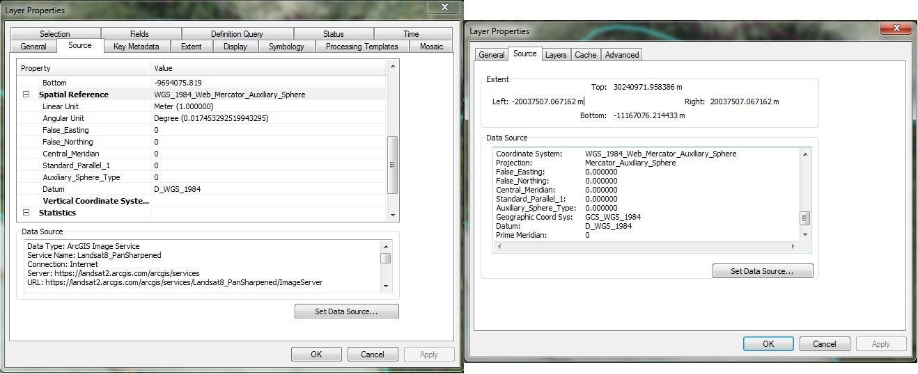
Below is the Source info for the Data Frame, in case that is helpful information.
NAD_1983_HARN_Virginia_Lambert
WKID: 3969 Authority: EPSG
Projection: Lambert_Conformal_Conic
False_Easting: 0.0
False_Northing: 0.0
Central_Meridian: -79.5
Standard_Parallel_1: 37.0
Standard_Parallel_2: 39.5
Latitude_Of_Origin: 36.0
Linear Unit: Meter (1.0)
Geographic Coordinate System: GCS_North_American_1983_HARN
Angular Unit: Degree (0.0174532925199433)
Prime Meridian: Greenwich (0.0)
Datum: D_North_American_1983_HARN
Spheroid: GRS_1980
Semimajor Axis: 6378137.0
Semiminor Axis: 6356752.314140356
Inverse Flattening: 298.257222101
Under Transformations within Data Frame Properties, I have GCS_WGS_1984 Into: GCS_North_American_1983_HARN Using: NAD_1983_HARN_To_WGS_1984_2.
Not sure what I'm missing here. This misalignment doesn't matter for my purposes, but I am curious about why it occurs. Any information would be helpful, and thanks in advance for the help.
EDIT: I've tried adding these two layers, World Imagery and Pansharpened Landsat in a new MXD, and I experience the same issue. It appears that in relation to the World Imagery, the Landsat layer experiences a subtle slide to the southeast. I don't believe this is just due to the resolution being substantially different, as this consistent directional shift is pretty apparent everywhere as far as I can tell. It also doesn't seem to be shadows making it look like a slide, but I guess that's possible.
EDIT AGAIN: Does this have something to do with the fact that both of these layers are made up of stitched together remotely sensed imagery, each tile of which is essentially a "flat" representation of a curved surface, so there will be some distortion at the edge of each "tile?" I would understand if that was the case, but it still appears to be a uniform misalignment, with the Landsat always sliding southeast relative to the World Imagery, so I don't know how this explanation would apply.
- Mark as New
- Bookmark
- Subscribe
- Mute
- Subscribe to RSS Feed
- Permalink
- Report Inappropriate Content
I have noticed that the World Imagery layer appears shifted in certain areas. I tried every transformation I could find, thinking it was a datum transformation issue, but that made no difference. I noticed it when trying to show the imagery with a parcel layer provided by the county I was in. The parcels were shifted about 20 feet off from the underlying basemap. And it seems to have popped up over the last six months, as I didn't have this issue in the same areas at the beginning of the summer with the same parcel data. Using the World Imagery (Clarity) layer, there appears to be no shift, so maybe try that for comparison.
- Mark as New
- Bookmark
- Subscribe
- Mute
- Subscribe to RSS Feed
- Permalink
- Report Inappropriate Content
I am having almost the same issue. I have noticed a shift from ArcMap and ArcPro. I am using the same image layer (World Imagery Clarity) in map and digitized features but when I open the digitized features in Pro the image (World Imagery Clarity) has shifted in Pro.
Has anyone else noticed this shift between map and pro?
- Mark as New
- Bookmark
- Subscribe
- Mute
- Subscribe to RSS Feed
- Permalink
- Report Inappropriate Content
Different imagery sources have different horizontal accuracy specifications. Landsat 8 is stated to have a 12 meter CE90 (meaning 90 percent of points measured on that imagery fall within 12 meters of true location). World Imagery has a number of different imagery sources and variable accuracy depending on your zoom level and geographic location of interest. For more on accessing World Imagery metadata (including information on accuracy) see this ArcGIS Blog post. Given the variability in horizontal accuracy between Landsat 8 and high resolution World Imagery sources, it is not unusual to see relative shifting/offsets between the two.
Image accuracy is stated in the form of a statistical confidence across a particular area or product. A number of variables will influence the final accuracy of the (orthorectified) imagery at any particular location. Variability in ground control, topographic relief, lens distortion, and camera tilt may result in localized image shifts/offsets.
If an update occurs in World Imagery that has some form of regression for a particular use case, and the previous imagery is more desireable, Wayback enables users to access previous versions of World Imagery. See the ArcGIS Blog site for posts related to Wayback.
- Mark as New
- Bookmark
- Subscribe
- Mute
- Subscribe to RSS Feed
- Permalink
- Report Inappropriate Content
Would this explain the difference between the same image in Pro and Map?
- Mark as New
- Bookmark
- Subscribe
- Mute
- Subscribe to RSS Feed
- Permalink
- Report Inappropriate Content