- Home
- :
- All Communities
- :
- Products
- :
- Imagery and Remote Sensing
- :
- Imagery Questions
- :
- Visual deformation in drone2map
- Subscribe to RSS Feed
- Mark Topic as New
- Mark Topic as Read
- Float this Topic for Current User
- Bookmark
- Subscribe
- Mute
- Printer Friendly Page
Visual deformation in drone2map
- Mark as New
- Bookmark
- Subscribe
- Mute
- Subscribe to RSS Feed
- Permalink
- Report Inappropriate Content
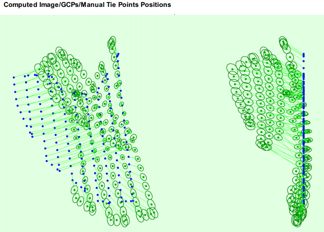
Can someone tell what went wrong in the following image, according to the processing report the cameras have been probably calibrated and alle images have been used. But the final orthomosaic is still deformed.
- Mark as New
- Bookmark
- Subscribe
- Mute
- Subscribe to RSS Feed
- Permalink
- Report Inappropriate Content
Jeppe
You need to use ground control in your project. Can you extract usable points from the Esri imagery basemap? They are not highly accurate - may be off by a meter or more - but even approximate control points will prevent the imagery positions from drifting so far from their proper locations.
Please also check to see if the Z values in your images look correct. This:
CameraOptimization: 61.42%relative difference between initial and optimized internal camera parameters
indicates that the height values may be incorrect, and it can give you a bad value for focal length. Drone2Map allows you to adjust Z values before processing.
(I would recommend you create a new project - making these changes in your existing project may not work as well as a fresh start)
Cody B.