- Home
- :
- All Communities
- :
- Products
- :
- Imagery and Remote Sensing
- :
- Imagery Questions
- :
- Tiff Raster- Colour outside of ArcGIS, Black White...
- Subscribe to RSS Feed
- Mark Topic as New
- Mark Topic as Read
- Float this Topic for Current User
- Bookmark
- Subscribe
- Mute
- Printer Friendly Page
Tiff Raster- Colour outside of ArcGIS, Black White in ArcGIS
- Mark as New
- Bookmark
- Subscribe
- Mute
- Subscribe to RSS Feed
- Permalink
- Report Inappropriate Content
I have extracted a subsection of a large raster. The file displays in full colour outside of ArcGIS but when imported into ArcMap or Pro it display as black and white despite being set to display in colour/all bands.
Tried rerunning calculation of its statistics in Catalog so far.
Thanks
Gavin
Solved! Go to Solution.
Accepted Solutions
- Mark as New
- Bookmark
- Subscribe
- Mute
- Subscribe to RSS Feed
- Permalink
- Report Inappropriate Content
Hi,
the file is just fine 🙂 But you should recreate the overviews - they seem to be corrupt - and make sure the file is interpreted as "processed" and not stretched when loaded:
So proceed like this:
Go to the folder you stored the data in and delete the *.ovr file
In Catalog /(or Folder view in Pro) open the properties of the dataset and define the source type as "Processed".
In Catalog /(or Folder view in Pro) open the properties of the dataset and REMOVE the NOData value (set to 255,255,255) to be empty.
Now right-click the image again and create new Pyramids - Nearest Neighbor/LZ77 works fine for this data
When adding it to the display now, everything should be fine and since you did Nearest/LZ77 you can still set 255,255,255 background color to be transparent (in the Symbology of the layer) and it will look fine on all levels. I attached the result
Regards
Guenter
- Mark as New
- Bookmark
- Subscribe
- Mute
- Subscribe to RSS Feed
- Permalink
- Report Inappropriate Content
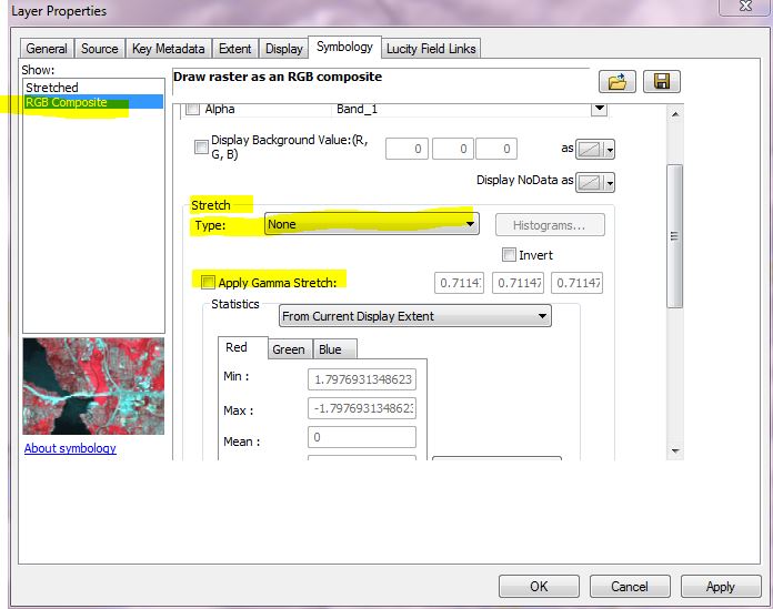
I've been having the same problem: Raster images display B&W in ArcMap when they are in fact color.
The solution was Guenter's first one: stretching. Go into Layer Properties>Symbology. Select RGB Composite. Duh you knew all that, why is it still B&W? There is a second place where stretching is applied. Under RGB, set Stretch type equal to none and uncheck 'Apply gamma Stretch'. Not exactly hidden but not immediately obvious.
(I am on 10.2.2)