- Home
- :
- All Communities
- :
- Products
- :
- Imagery and Remote Sensing
- :
- Imagery Questions
- :
- Tabulate Area tool making up NoData in output tabl...
- Subscribe to RSS Feed
- Mark Topic as New
- Mark Topic as Read
- Float this Topic for Current User
- Bookmark
- Subscribe
- Mute
- Printer Friendly Page
Tabulate Area tool making up NoData in output table
- Mark as New
- Bookmark
- Subscribe
- Mute
- Subscribe to RSS Feed
- Permalink
- Report Inappropriate Content
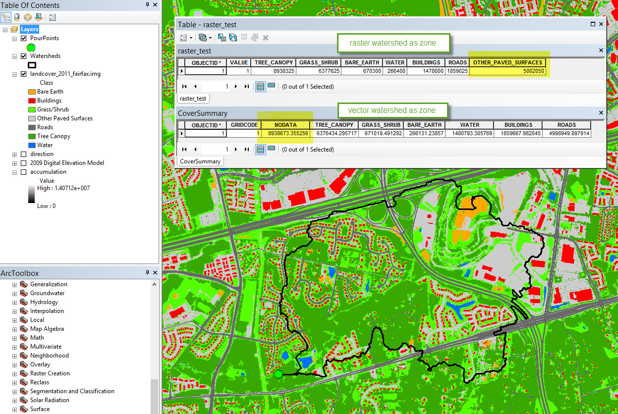
I'm running a model that tabulates land cover area inside a watershed polygon and the output table shows significant NoData square footage while ignoring one of the true land cover classes in the land cover raster. There are no NoData pixels inside the watershed polygon (see attached). The raster_test table shows the correct result when a raster version of the watershed is input as the zone to Tabulate Area, while the CoverSummary table shows the incorrect tabulation of NoData area when a vector watershed is the zonal input. In this case, the vector watershed tabulation ignores the OTHER_PAVED_SURFACES land cover type. Why does this happen? I realize the workaround would be to use the raster watershed as the zone, but this seems like it should work either way. The error has occurred in ArcMap 10.2.2 and 10.4.
- Mark as New
- Bookmark
- Subscribe
- Mute
- Subscribe to RSS Feed
- Permalink
- Report Inappropriate Content
cell sizes and counts equal area, when using vector as zone, it is best to convert explicitly to a raster specifying the same size and extent as what you want to tabulate since there is no guarantee they will remain the same.
- Mark as New
- Bookmark
- Subscribe
- Mute
- Subscribe to RSS Feed
- Permalink
- Report Inappropriate Content
Dan,
Thank you for your reply. What do you mean by "cell sizes and counts equal area...?" The watershed is a raster when it is first delineated by my model, so I can certainly use the raster version, but I'm trying to understand what is happening when a vector zone is used. I've been using Tabulate Area with vector zones for a long time to do this kind of work and have never had this problem. It's especially useful when I have a vector with a large number of polygons such as parcels, census geographies, etc.
- Mark as New
- Bookmark
- Subscribe
- Mute
- Subscribe to RSS Feed
- Permalink
- Report Inappropriate Content
From here Tabulate Area—Help | ArcGIS for Desktop
it is the little things...
If the zone input is feature dataset, a vector-to-raster conversion will be internally applied to it.
To ensure that the results of the conversion will align properly with a class raster input, it is recommended that you check that the extent and snap raster are set appropriately in the environment settings and the raster settings.
It is generally recommended to only use rasters as the zone and class inputs. If your inputs are feature, consider converting them to rasters first with the To Raster conversion tools. This offers you greater control over the vector-to-raster conversion, helping to ensure you consistently get the expected results.
Then there are other associated issues...
Working with Tabulate Area—Help | ArcGIS for Desktop
When working with raster, work with raster fully since you should be controlling your environment settings completely rather than relying on defaults and software interpretations of exactly what you want or is needed.
- Mark as New
- Bookmark
- Subscribe
- Mute
- Subscribe to RSS Feed
- Permalink
- Report Inappropriate Content
Error code 010423 "[Raster] does not have valid statistics as required by the operation" has come up when running Tabulate Area using a raster watershed as the zone. I've built and rebuilt statistics on my land cover raster with a skip factor of 1 and no ignore value, so I don't know why this is happening again (it didn't a day or two ago).
- Mark as New
- Bookmark
- Subscribe
- Mute
- Subscribe to RSS Feed
- Permalink
- Report Inappropriate Content
how many watersheds do you have and how small are they? when using the vector version, it is less 'fine' and more generalized, that is probably why you didn't get 'issues' in the error sense but it raises other problems. You can either generalize your watersheds and redo the statistics etc and/or split in at least even pieces if the area is large.
Also... a recent tip... shut everything down, load the inputs into a new geodatabase and start again. It seems that geodatabases get messy and a good flush and reboot often clears out seemingly unrelated problems.