- Home
- :
- All Communities
- :
- Products
- :
- ArcGIS Image Server
- :
- ArcGIS Image Server Questions
- :
- Re: Removing unnecessary white areas from Tilled I...
- Subscribe to RSS Feed
- Mark Topic as New
- Mark Topic as Read
- Float this Topic for Current User
- Bookmark
- Subscribe
- Mute
- Printer Friendly Page
Removing unnecessary white areas from Tilled Imagery
- Mark as New
- Bookmark
- Subscribe
- Mute
- Subscribe to RSS Feed
- Permalink
- Report Inappropriate Content
Hello all,
Hope you are all healthy and keeping safe.
How can I remove unnecessary white areas from Tilled Imagery? In Arc Pro these areas are not visible. There are no No Data Values in this imagery when using in Pro. I have tried masking No Data, but when I cache it and upload to Enterprise, I still get white areas.
My workflow :
Share as Tile
Apply Tilling scheme from Existing Tilled service
Cache Locally
and upload it online.
I share the image as web layer by ticking the box "Tile"
- Mark as New
- Bookmark
- Subscribe
- Mute
- Subscribe to RSS Feed
- Permalink
- Report Inappropriate Content
Benas,
there are many questions arising - mainly:
- Whats the source of the original tiled data (8bit, 16bit, ...)?
- Did you set any properties in the MapView (about Transparency and NoData Display)
- Did you add/store it in a MosaicDataset?
- If you can provide one of the source images - I can help you clarify the details and explain the way to go
Regards
Guenter
- Mark as New
- Bookmark
- Subscribe
- Mute
- Subscribe to RSS Feed
- Permalink
- Report Inappropriate Content
Hello again,
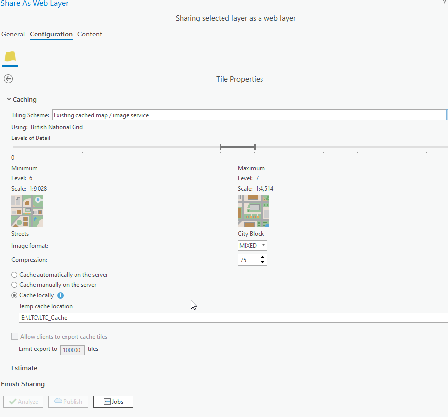
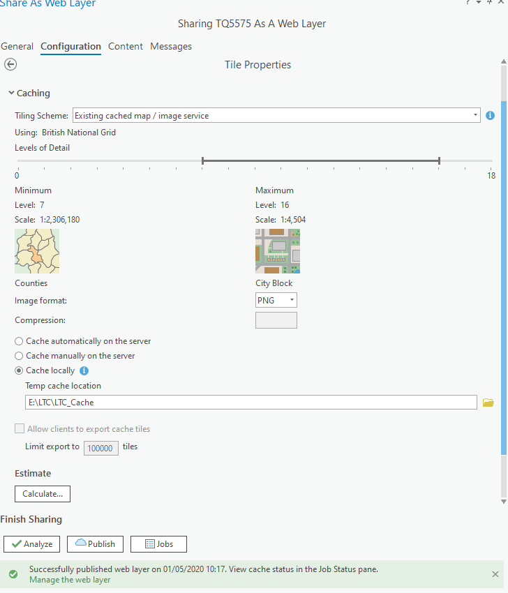
I have expanded Scale levels and changed Image format for Tilling. It appears worked for one single image. Will see how this works on full mosaic dataset.
Guenter Doerffel, would you mind elaborating and sending me some resources of best practices of Image cacheing. ?
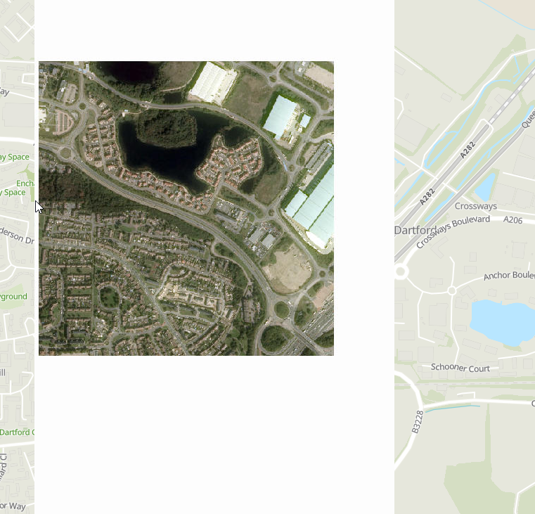
From this: 
To This :
- Mark as New
- Bookmark
- Subscribe
- Mute
- Subscribe to RSS Feed
- Permalink
- Report Inappropriate Content
Hello Guenter,
Thank you for reply.
For testing purposes I did not use Mosaic Dataset for this. I used one raw image. Please see image specifications below:

I can provide you with the image. How can I do it ? Where shall I send it ? Size of image is 183MB
- Mark as New
- Bookmark
- Subscribe
- Mute
- Subscribe to RSS Feed
- Permalink
- Report Inappropriate Content
Hi Benas,
so the input-Imagery is 8bit (with interesting statistics  ).
).
As you already stated it has no "NoData" defined - but the screenshot above makes me assume the NoData is meant to be 255/255/255.
Compression JPEG - so this causes a risk for Artifacts on the boundaries.
Your best way to solve this is very likely the MosaicDatset and its advanced methods to specify NoData and use the boundary/footprints to handle.
Then you have a clean source for the tile generation.
If the images overlap in the "white" areas and in fact there are no "holes" in the data, you might be able to solve it just using the "minimum" operator for the overlap.
If you want to send a mail: g-point-doerffel-at-esri-dot-com
- Mark as New
- Bookmark
- Subscribe
- Mute
- Subscribe to RSS Feed
- Permalink
- Report Inappropriate Content
Hi Benas,
your inline question above on "Best practices" for Caching is best answered with a reference to the Image Management Workflows section of the Web doc.
There is one workflow description: Serving cached Imagery that has a lot of helpful resources linked into it. It also contains a link to a little toolbox that is meant to help creating caches from Mosaic Datasets in a simplified way. Check this out first, please.
Hope your NoData topic is solved. If not, feel free to send me access to one of the images.
G.
- Mark as New
- Bookmark
- Subscribe
- Mute
- Subscribe to RSS Feed
- Permalink
- Report Inappropriate Content
Thank you very much for you input.
As you said, with mosaic data set its much easier. It works fine for mosaic dataset.
Thank you for Image Management Workflows. I have downloaded the toolbox and took a look. I will have to explore it properly. Though I see the tool doesnt have an option to use Tilling Schema from another service or use our own Schema, this might be an issue for us.