- Home
- :
- All Communities
- :
- Products
- :
- Imagery and Remote Sensing
- :
- Imagery Questions
- :
- Re: Raster NoData Value
- Subscribe to RSS Feed
- Mark Topic as New
- Mark Topic as Read
- Float this Topic for Current User
- Bookmark
- Subscribe
- Mute
- Printer Friendly Page
- Mark as New
- Bookmark
- Subscribe
- Mute
- Subscribe to RSS Feed
- Permalink
- Report Inappropriate Content
Hi, I have some lidar DTM in mm that needs to be converted into meter keeping the Nodata value as it is (i.e. -9999). Converting them to M is fine but it changes the NoData value and causes problem when I tried to create Mosaic dataset overview . Could someone please help me on this?
Many thanks,
Rajib
Solved! Go to Solution.
Accepted Solutions
- Mark as New
- Bookmark
- Subscribe
- Mute
- Subscribe to RSS Feed
- Permalink
- Report Inappropriate Content
Mohammed
You do not need to run the raster calculator to create a copy of each file with Z value in Meters! The Mosaic Dataset is designed to work with your *original* data and process all of it together to ensure everything is done the same (and avoid creating extra files). If you add your original data to the Mosaic Dataset, you can add an Arithmetic function onto the entire collection to rescale from millimeters to meters.
Then in the properties of the mosaic dataset, define your nodata value. This will make maintenance much easier...
Cody B.
- Mark as New
- Bookmark
- Subscribe
- Mute
- Subscribe to RSS Feed
- Permalink
- Report Inappropriate Content
Set the NoData property of on the dataset. NoData values will then be ignored in the computation.
- Mark as New
- Bookmark
- Subscribe
- Mute
- Subscribe to RSS Feed
- Permalink
- Report Inappropriate Content
Hi Peter,
Where do I set the NoData property off? I was using raster calculator/Times tools to convert them from mm to m, approximately 150 raster tiles. And then I was adding them to the mosaic dataset- calculate statistics - build overview.
Thank you.
- Mark as New
- Bookmark
- Subscribe
- Mute
- Subscribe to RSS Feed
- Permalink
- Report Inappropriate Content
Mohammed,
a MosaicDataset has a property for NoData that can be set - if NoData is homogeneous for all datasets in it. In ArcMap and in ArcGIS Pro you find it in the GENERAL Tab of the MosaicDataset Properties.
If you have different NoData amongst elements or/and want to apply NoData as a proper mask on each dataset, use the Define Mosaic Dataset NoData GP Tool: (Define Mosaic Dataset NoData—Help | ArcGIS Desktop )
There are many more options with this tool, ranging from multiple NoData Values to very useful AND and OR functions usable on a per-band-level. This tool will add a MASK function to the elements in your MosaicDataset. Dont forget to properly recompute footprints afterwards and/or have the appropriate footprint-settings regarding NoData in your MosaicDataset!
Guenter
- Mark as New
- Bookmark
- Subscribe
- Mute
- Subscribe to RSS Feed
- Permalink
- Report Inappropriate Content
Hi Guenter,
Thank you very much. An excellent suggestion, I never used this tool but I can see how useful it will be for me.
Just one more thing, when I was using raster calculator to convert the z value from mm to m I tried to use both con and setnull to make sure nodata value -9999 stay as it is and rest changes to m. But it was converting the -9999 as well! con statement I used is Con("test3" != -9999, "test3"*0.001, "test3").
Thank you again.
- Mark as New
- Bookmark
- Subscribe
- Mute
- Subscribe to RSS Feed
- Permalink
- Report Inappropriate Content
Hi Mohammed,
its been ages I used Con - meaning to say I would not convert from mm to m using Con but follow i.e a workflow like this:
- Create the SOURCE MosaicDataset with the Original data (mm)
- Use the Define NoData function as mentioned above
- Recompute the footprints if needed
- If wanted, create Overviews ...
Now you have an easily maintainable "raw" version of your data, and a 'm'-Version is just ONE way to use it ...
So - to create a 'self-maintaining' usable version of it that represents 'm' - Values:
- Create a Referenced MosaicDataset pointing to the one above
- Add the Arithmetic Function on the Mosaic Level - like this (use your decimal delimiter!):
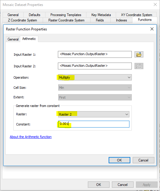
- In the General - Tab make sure your Output data type is what you want!
- Re-calculate the statistics for this Referenced Mosaic!
Now you have a 'm'-Mosaic with clean NoData. If you need nothing else but this 'm'- Version, you could also add this Arithmetic Function to the Source Mosaic defined above
Is that an idea for you?
Guenter
- Mark as New
- Bookmark
- Subscribe
- Mute
- Subscribe to RSS Feed
- Permalink
- Report Inappropriate Content
Hi Guenter and Perter,
Thank you very much to both of you. It has been a great help.
I am developing lidar DSM and DTM mosaic for Scotland (all available data in public sector). It is a fairly large dataset and going through some hard time to maintain it, especially trying to add new raster to the existing dataset!! I am sure I will ask more question in future.
Thank you again,
Mohammed
- Mark as New
- Bookmark
- Subscribe
- Mute
- Subscribe to RSS Feed
- Permalink
- Report Inappropriate Content
Mohammed
You do not need to run the raster calculator to create a copy of each file with Z value in Meters! The Mosaic Dataset is designed to work with your *original* data and process all of it together to ensure everything is done the same (and avoid creating extra files). If you add your original data to the Mosaic Dataset, you can add an Arithmetic function onto the entire collection to rescale from millimeters to meters.
Then in the properties of the mosaic dataset, define your nodata value. This will make maintenance much easier...
Cody B.
- Mark as New
- Bookmark
- Subscribe
- Mute
- Subscribe to RSS Feed
- Permalink
- Report Inappropriate Content
Hi Cody,
Thank you for your kind reply. I am aware of the Arithmetic function. But I have approximately 10000 raster tiles spread over 7 different folder and around 300 of them from one source are in mm. so if I were to apply function I would have to do it individually, isn't it? And just found few of them are in 64bit where my mosaic dataset is 32bit float!
I can see all of you have in depth knowledge on Mosaic dataset. Would it be possible to discuss my mosaic workflow with any of you? I kind of learn it by experimenting it. An expert look would really help me.
Many thank s,
Mohammed
- Mark as New
- Bookmark
- Subscribe
- Mute
- Subscribe to RSS Feed
- Permalink
- Report Inappropriate Content
Hi Mohammed,
agreed - Mosaics are great and offer a lot of possibilities, settings, options. If you would like to learn about suggested workflows, there is a great site for this:
As you mention that you are having a hard time updating your services with new data coming in: Guess in your case there would be a lot to discuss about
- Managing elevation data, Part 1: About elevation data—Help | ArcGIS for Desktop
- Synchronize Mosaic Dataset—Help | ArcGIS Desktop in conjunction with the Table Raster Type
- Adding lidar data to a mosaic dataset—Help | ArcGIS Desktop
But this forum is not replacing individual training or a potentially very useful contact with your local distributor. I"d go for the latter to receive in-depth consulting on Mosaics
Regards
Guenter