- Home
- :
- All Communities
- :
- Products
- :
- Imagery and Remote Sensing
- :
- Imagery Questions
- :
- Mosaic to New Raster not including rasters
- Subscribe to RSS Feed
- Mark Topic as New
- Mark Topic as Read
- Float this Topic for Current User
- Bookmark
- Subscribe
- Mute
- Printer Friendly Page
Mosaic to New Raster not including rasters
- Mark as New
- Bookmark
- Subscribe
- Mute
- Subscribe to RSS Feed
- Permalink
- Report Inappropriate Content
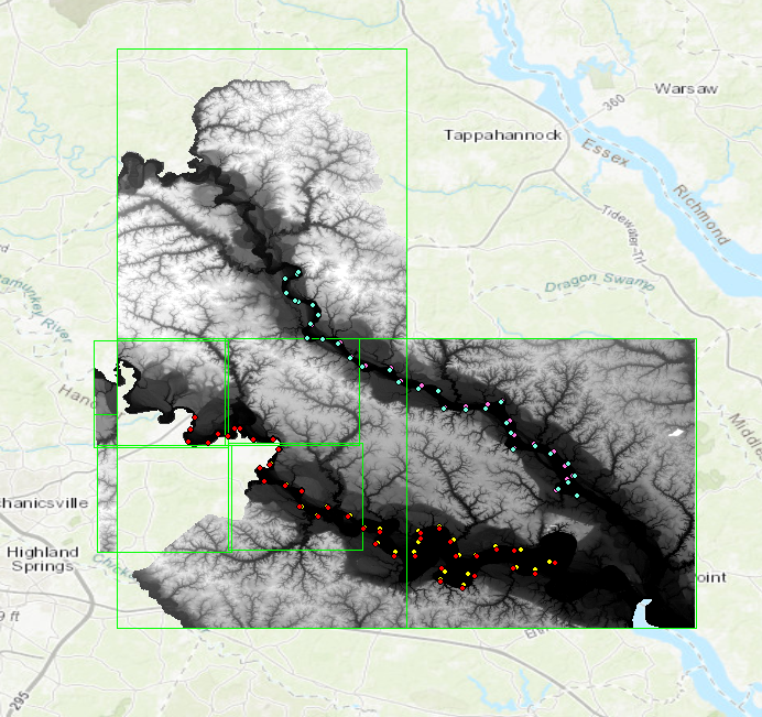
Hi, I am a new user of ArcMap 10.7 and keep running into this issue. I am trying to mosaic 13 DEM rasters into a single IMG file. The original DEM's had different coordinate systems so I projected them into the same coordinate system. I am now trying to mosaic those projections but I am only getting some of them to pop up in the final output. I will attach a picture to show what I mean. There is supposed to be data displayed in middle and bottom half of this image.
Separately, I can view all the DEM's fine (i.e. before I try to mosaic). I can also zoom in and out of the final mosaic raster and that does not change what appears. I even tried using the Union setting under the Environment tab but that did not change anything. I also tried mosaicing the rasters that do not show up separately and that did work better, but I still couldn't get full coverage. I made sure that all my files are where they should be so I am at a loss for what to try next.
Any help would be appreciated, I have been using ArcMap for a little over a week so I apologize in advance if this is a simple fix. I have read all the forums related to this topic and none seem to work.
- Mark as New
- Bookmark
- Subscribe
- Mute
- Subscribe to RSS Feed
- Permalink
- Report Inappropriate Content
For reference this is what it looks like when they are separate. The dots are GPS points. 
- Mark as New
- Bookmark
- Subscribe
- Mute
- Subscribe to RSS Feed
- Permalink
- Report Inappropriate Content
I presume you are using the mosaic tool currently to mosaic the elevation datasets together. One possible cause of what you are seeing is that NoData may not have been correctly defined for the different datasets. I would generally recommend against mosaicking the images together. When msoaicking different sources you will be re-projecting and resampling the source which will cause various artifacts. I would recommend instead to create a mosaic dataset from the source elevation data. This can be used as a single raster for your analysis and you can define extensive rules for how the elevation data gets mosaicked together and easily check as different parameters are changed. You can use the mosaic dataset directly in analysis or export a section (or all) if required.
- Mark as New
- Bookmark
- Subscribe
- Mute
- Subscribe to RSS Feed
- Permalink
- Report Inappropriate Content
Thank you for your response! I created the mosaic dataset and was able to get all of my 1/9 arc second DEMs mosaiced properly. However, I noticed that it doesn't want to display the one meter DEMs. How can I fix that? The cell size of the overall mosaic is the same as the cell size for the 1 meter DEMs so I would expect them to appear.
Thanks again.
- Mark as New
- Bookmark
- Subscribe
- Mute
- Subscribe to RSS Feed
- Permalink
- Report Inappropriate Content
Most probably related to the Min/Max Pixel sizes values set in the mosaic dataset footprint table, which controls what images get displayed at what scale. By default the system will set these values so that you see different datasets depending on the scale you are zoomed in at. By changing the values you can control this. Note also that there are controls on the mosaic method to define what image goes above what and how the pixels get blended. Do check out the various documentation on mosaic method. For a details look at how best to work with elevation data check out the Managing Elevation workflow