- Home
- :
- All Communities
- :
- Products
- :
- Imagery and Remote Sensing
- :
- Imagery Questions
- :
- Re: How to use specific bands from the Landsat 8 S...
- Subscribe to RSS Feed
- Mark Topic as New
- Mark Topic as Read
- Float this Topic for Current User
- Bookmark
- Subscribe
- Mute
- Printer Friendly Page
How to use specific bands from the Landsat 8 Service
- Mark as New
- Bookmark
- Subscribe
- Mute
- Subscribe to RSS Feed
- Permalink
- Report Inappropriate Content
I am using the Multispectral Landsat imagery service from AGO. I want to do some Raster Calc math on Bands 4 and 5.
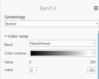
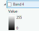
So far I can find no way to get Raster calc to see the values of the other bands. I can change the Processing Template over to Color Infrared and then see bands 4 and 5 on the screen. But the values are always 0-255 not the actual values - even when using stretch.
When I have the raw image separating out the bands using Catalog is no problem. But how can i do this with the service? I was to avoid any downloading.
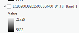
Raw Image values
Service Values
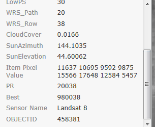
I can see some other pixel values in Identify.
What am i missing.
Thanks for any help.
- Mark as New
- Bookmark
- Subscribe
- Mute
- Subscribe to RSS Feed
- Permalink
- Report Inappropriate Content
You need to set the processing template to None or function that does not include DRA.
'None' will return you the Radiance values (currently scaled 5000 - 55000, but will be changing soon to be scale from 0 - 10000). If you set one of the other processing chains then it will be returned stretched to 0-255.
If you use None then things will slow down as the server will be returning 16bit data. You can speed this up by setting the compression to LERC and using a tolerance such as 4 or 8.
Optimum is to create a function and transmit it to the Server to be processed there an return only the result. This can be done by using the Raster Functions in Pro.
If using Desktop also check out Landsat 8 Image Service Add-In Tools
http://www.arcgis.com/home/item.html?id=f331af8569fb4f19bd74954eddc44bd3
- Mark as New
- Bookmark
- Subscribe
- Mute
- Subscribe to RSS Feed
- Permalink
- Report Inappropriate Content
Thanks that worked for display. I can now see a better range.


I see no options for LERC. This is a service remember not a raw image. But it is not too slow so no biggie.
But I am still having an issue with Raster Calc. It seems like the display is changing to the other band values but when running Raster Calc it always gets the same value. So Band 4 minus Band 5 is always 0. Works on the raw image no problem.
Values are there but how do I get them out?

So how can I change not just the display but use the values?
Thanks
- Mark as New
- Bookmark
- Subscribe
- Mute
- Subscribe to RSS Feed
- Permalink
- Report Inappropriate Content
Ok this may have worked. I tried this before but not when it was set to None like you said.
Open the Image Analysis window
Add a function
Function is Extract Bands

Pick the band you want
i set Combination to just the one I want but not sure this is correct?

I am getting better results now.
Is this correct?
Thanks
- Mark as New
- Bookmark
- Subscribe
- Mute
- Subscribe to RSS Feed
- Permalink
- Report Inappropriate Content
Yes. This is one way to go. You can now start adding additional functions including any band arithmetic that you want to do. No need to use raster calculator as a GPTool, you can do all the processing as the data is accessed.
If you use Pro you can create similar raster functions and transmit them so they are processed on the server and only the result it transmitted back.
If you do want to use Raster Calculator you need to first use Make Image Service layer and defined properties to create a virtual raster layer that can then be used.