- Home
- :
- All Communities
- :
- Products
- :
- Imagery and Remote Sensing
- :
- Imagery Questions
- :
- How do i change the precision of the identify tool...
- Subscribe to RSS Feed
- Mark Topic as New
- Mark Topic as Read
- Float this Topic for Current User
- Bookmark
- Subscribe
- Mute
- Printer Friendly Page
How do i change the precision of the identify tool for floating point raster data
- Mark as New
- Bookmark
- Subscribe
- Mute
- Subscribe to RSS Feed
- Permalink
- Report Inappropriate Content
Hi,
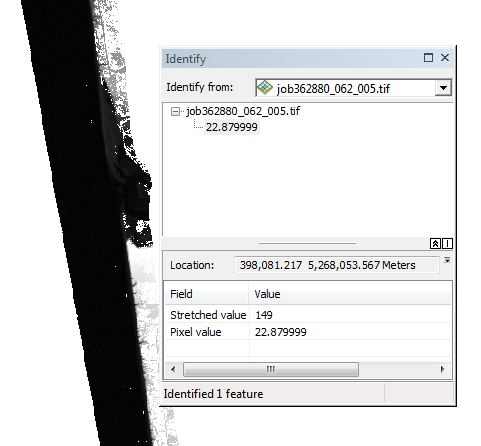
When I'm using the identify tool on floating point raster data (it's a tif file), how can I change the number of decimal places of the pixel value returned by the tool? In the attached screen shot I have six decimal places showing. How might I make that, say, four decimal places showing (without truncating the actual data).
I can see how I might do this for feature layers that have an attribute table, but a floating point raster has no table so no joy there.
Thanks,
Tim
- Mark as New
- Bookmark
- Subscribe
- Mute
- Subscribe to RSS Feed
- Permalink
- Report Inappropriate Content
Sorry, ArcMap version is 10.3.1 on Windows 7 64bit
- Mark as New
- Bookmark
- Subscribe
- Mute
- Subscribe to RSS Feed
- Permalink
- Report Inappropriate Content
From what I can see you can't. Is there a purpose for the request? since it is just an info tool, I wouldn't pay to much attention to the decimals, it almost looks like it is single precision
- Mark as New
- Bookmark
- Subscribe
- Mute
- Subscribe to RSS Feed
- Permalink
- Report Inappropriate Content
Hi Tim,
a few hints:
1) Pixel Inspector Tool
though this will not solve your issue and also display the full coordinates but comes very handy when querying attributes of Raster Data: Check out via Customize => Commands => Category Raster => Command: Pixel Inspector Tool. Is much easier and shows you neighboring pixels as well as a choice of Raw and Rendered Values.
2) A raster process applied - Find attached a zipped python file. This is a little sample raster process based on the arithmetic function. It works nicely to display only integers and rounded integers (for 1 Band rasters) - but trying to apply rounding on 10th/100th/1000th unfortunately will keep showing a lot of decimals - must be something because of the float data type.
To use this sample - just refer to the help about applying Raster Functions - and use the input line for python raster functions. Best start of from the Image Analysis Window.
To understand, modify, learn: read the help about Python Raster functions and if interested also check the functions provided on github.
3) MosaicDataset again
Since you most likely identify on Source resolution level - here an easy way to get Integers displayed 🙂
- Create a MosaicDatset that is Integer only and add your data ... There is no "Doubling up" of data that way - you just query it in a different way
Regards
Guenter