- Home
- :
- All Communities
- :
- Products
- :
- Imagery and Remote Sensing
- :
- Imagery Questions
- :
- Re: Esri Full Motion Video in ArcGIS Pro
- Subscribe to RSS Feed
- Mark Topic as New
- Mark Topic as Read
- Float this Topic for Current User
- Bookmark
- Subscribe
- Mute
- Printer Friendly Page
- Mark as New
- Bookmark
- Subscribe
- Mute
- Subscribe to RSS Feed
- Permalink
- Report Inappropriate Content
Hi Esri,
I'm trying to create a georeferenced video with the shape files displayed in the video. I just have a few questions:
1. In ArcMap, there is a function "Start displaying features from map on video". I cannot seem to locate it in ArcGIS Pro.
2. In ArcMap, I am able to record the video metadata containing the frame corners and etc after I use the Video Multiplexer. I cannot seem to locate it in ArcGIS Pro. It is helpful for analyzing the calculated results.
3. What are the camera and gimbal systems used in the FMV Tutorial Desktop (1.3.1) regarding this file "CheyenneVAhospital.mpeg4". Also, does the system record MISB data directly or just the minimum which is used later to calculate the corners.
4. I'm currently using the Garmin Virb Ultra 30 to record the footage and generate the CSV to create the multiplexed video but there seems to be some issues due to Garmin GPS accuracy (as well as heading). Are there recommended systems available?
5. Also, sometimes the metadata of the multiplexed video has empty values for corners.. which results in the camera view port stretching to infinity.. What can I do to mitigate that?
Any help would be greatly appreciated!
Thank you!
Francis
Solved! Go to Solution.
Accepted Solutions
- Mark as New
- Bookmark
- Subscribe
- Mute
- Subscribe to RSS Feed
- Permalink
- Report Inappropriate Content
Francis
addressing your points sequentially:
- The capability to overlay GIS Feature data in the video window has not been ported from ArcMap into ArcGIS Pro. We expect this to be available in Pro 2.3
- I am not sure I understand the question. You said "record" the video metadata; do you mean "display"? If you right click on the video in the TOC, you can display the metadata

- The camera used for that demonstration flight (Denver/Cheyenne) was a military grade system that embedded the MISB metadata into the video in realtime.
- The Garmin Virb Ultra 30 is an excellent camera for the price, but it is a consumer product and the accuracy of the built in orientation sensors is certainly limited. Are you asking about recommendations for other camera systems? we can provide recommendations but note the pricing for most will be 10 to 100x higher, and most require manned aircraft.
- With a low accuracy sensor, I will typically calculate a moving average in the metadata to smooth out any erroneous or missing values (using MS Excel). Create a new column and average 3 or more records into one value to see if that gives you results that appear better. You can also try simply filtering (in Excel) with a threshold to flag suspected errorneous or missing values, then enter what you feel would be appropriate values. Note these suggestions do NOT increase accuracy, but can help overcome data gaps or errors.
Cody B
- Mark as New
- Bookmark
- Subscribe
- Mute
- Subscribe to RSS Feed
- Permalink
- Report Inappropriate Content
2. An overview of the Motion Imagery toolset—Help | ArcGIS Desktop
Cody Benkelman incoming, apparently you are being tagged for questions
- Mark as New
- Bookmark
- Subscribe
- Mute
- Subscribe to RSS Feed
- Permalink
- Report Inappropriate Content
Francis
addressing your points sequentially:
- The capability to overlay GIS Feature data in the video window has not been ported from ArcMap into ArcGIS Pro. We expect this to be available in Pro 2.3
- I am not sure I understand the question. You said "record" the video metadata; do you mean "display"? If you right click on the video in the TOC, you can display the metadata
- The camera used for that demonstration flight (Denver/Cheyenne) was a military grade system that embedded the MISB metadata into the video in realtime.
- The Garmin Virb Ultra 30 is an excellent camera for the price, but it is a consumer product and the accuracy of the built in orientation sensors is certainly limited. Are you asking about recommendations for other camera systems? we can provide recommendations but note the pricing for most will be 10 to 100x higher, and most require manned aircraft.
- With a low accuracy sensor, I will typically calculate a moving average in the metadata to smooth out any erroneous or missing values (using MS Excel). Create a new column and average 3 or more records into one value to see if that gives you results that appear better. You can also try simply filtering (in Excel) with a threshold to flag suspected errorneous or missing values, then enter what you feel would be appropriate values. Note these suggestions do NOT increase accuracy, but can help overcome data gaps or errors.
Cody B
- Mark as New
- Bookmark
- Subscribe
- Mute
- Subscribe to RSS Feed
- Permalink
- Report Inappropriate Content
Hi Cody,
Thanks so much for you detailed and prompt response!
1. Sounds great! For the time being I will still use ArcMap for Full Motion Video. Would 2.3 be out at the end of 2018?
2. Yes sorry for the confusion. That is what I was referring to. Furthermore, in ArcMap, I was able to record the Multiplexed video metadata into a CSV file (see attached image). Does ArcGIS Pro does similar functions? 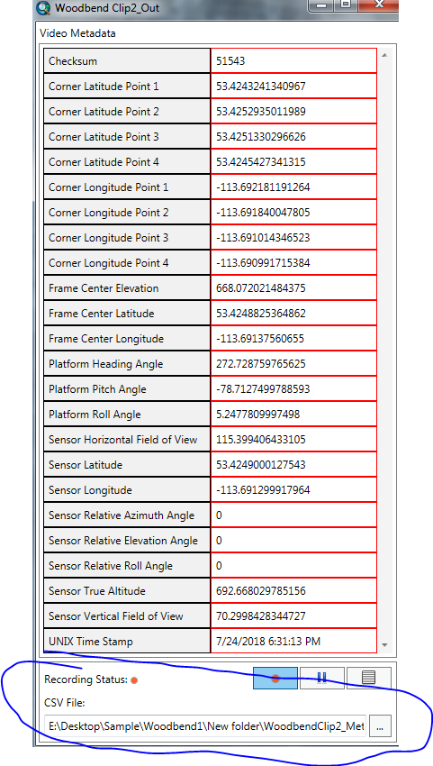
3/4/5. Understood. And currently we are trying to demonstrate the feasibility of FMV and show a proof of concept for our application, it is a really great add-in to integrate digital data into captured footage.
The final purpose is a helicopter inspection equipped with better hardware and gimbal systems. And yes, we are looking for camera system and possibly gimbal recommendations if you could please.
Sounds good! I will definitely clean up the metadata and recreate a multiplexed video afterwards!
Thank you very much once again!
Francis
- Mark as New
- Bookmark
- Subscribe
- Mute
- Subscribe to RSS Feed
- Permalink
- Report Inappropriate Content
Francis
sorry I didn't answer #2 properly. No, Pro 2.2 does not have the equivalent functionality to extract and save the metadata as *.csv. That will be available via a GP tool in Pro 2.3, due late this year.
I don't have a list of sources for compatible professional/military camera systems but offhand I can give you a few names:
- General Dynamics Cineflex
- FLIR Star Safire
- Imagery Delivered from Trilliumhttps://www.wescam.com/
- Cloud Cap Technology
- L3 WESCAM - Aerospace and Defense
- Camera Systems | UAV VISION
- Depending on the system you MAY need to add an encoder that performs the realtime multiplexing - one I know of is Makito Air | Haivision
Cody B
- Mark as New
- Bookmark
- Subscribe
- Mute
- Subscribe to RSS Feed
- Permalink
- Report Inappropriate Content
Hi Cody,
Sounds great! We will look forward to the release of V2.3 later this year.
Also thank you very much for the list of recommendations. We will get in touch with them in the immediate future.
Sincerely,
Francis