- Home
- :
- All Communities
- :
- Products
- :
- Imagery and Remote Sensing
- :
- Imagery Questions
- :
- Error 999999 Failed to execute computecameramodel ...
- Subscribe to RSS Feed
- Mark Topic as New
- Mark Topic as Read
- Float this Topic for Current User
- Bookmark
- Subscribe
- Mute
- Printer Friendly Page
Error 999999 Failed to execute computecameramodel help please!
- Mark as New
- Bookmark
- Subscribe
- Mute
- Subscribe to RSS Feed
- Permalink
- Report Inappropriate Content
Hi Everyone, New user to Arcgis Pro and having inconsistent results trying to produce orthomosaics.
The error code is 999999 and the error message is failed to execute "ComputeCameraModel".
I tried working with a smaller sample of images. The camera used is the Mapir Survey 3N and I have populated the camera parameters with the correct Focal length, Pixel size and columns and rows.
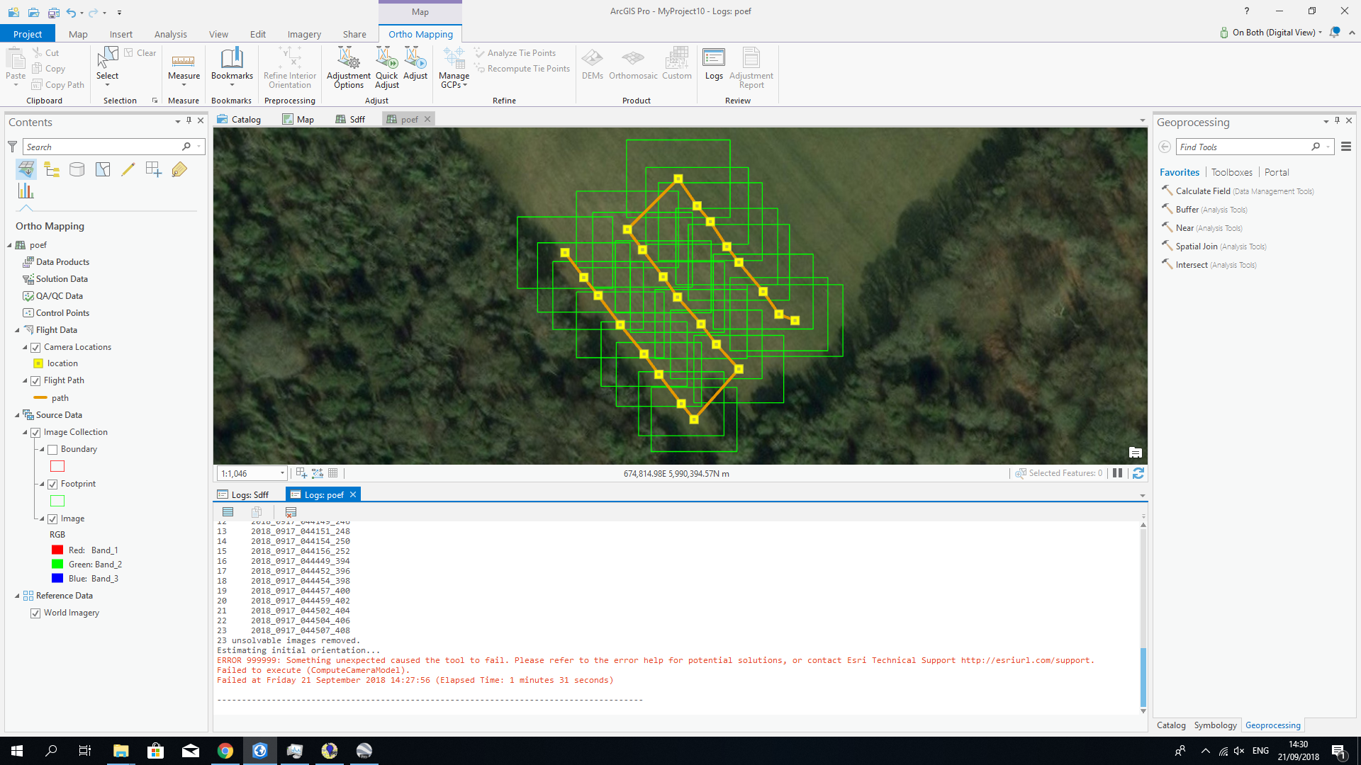
Here is a copy of the logs.
Queued...
Running...
Building image collection...
Start Time: Friday 21 September 2018 14:24:19
2018-09-21T14:24:33.256: Loading raster datasets
2018-09-21T14:24:33.330: Completed crawling 23 data source items. Added 23 mosaic dataset items.
2018-09-21T14:24:33.335: Synchronizing crawled data source items
2018-09-21T14:24:33.371: Synchronizing items associated with raster type instance 'UAV/UAS' [ID: 1].
2018-09-21T14:24:34.288: Estimating raster statistics for mosaic dataset.
2018-09-21T14:24:34.960: Completed synchronization: 23 items selected, 23 items synchronized.
2018-09-21T14:24:35.692: Computing cell size levels
2018-09-21T14:24:35.694: Computing unique cell size values
2018-09-21T14:24:35.796: Computing maximum cell size values
2018-09-21T14:24:35.817: Computing minimum cell size values
2018-09-21T14:24:35.833: Updating visibility values of selected items
2018-09-21T14:24:35.880: Computing maximum cell size for mosaic dataset
2018-09-21T14:24:35.897: Completed computing cell size ranges.
2018-09-21T14:24:35.989: Completed building boundary.
Succeeded at Friday 21 September 2018 14:24:38 (Elapsed Time: 18.77 seconds)
--------------------------------------------------------------------------------------
Queued...
Running...
Computing Block Adjustment...
Start Time: Friday 21 September 2018 14:26:25
Computing initial tie points...
Analyzing initial tie point coverage...
1 2018_0917_044116_220
2 2018_0917_044119_222
3 2018_0917_044121_224
4 2018_0917_044124_226
5 2018_0917_044127_228
6 2018_0917_044129_230
7 2018_0917_044132_232
8 2018_0917_044134_234
9 2018_0917_044141_240
10 2018_0917_044144_242
11 2018_0917_044146_244
12 2018_0917_044149_246
13 2018_0917_044151_248
14 2018_0917_044154_250
15 2018_0917_044156_252
16 2018_0917_044449_394
17 2018_0917_044452_396
18 2018_0917_044454_398
19 2018_0917_044457_400
20 2018_0917_044459_402
21 2018_0917_044502_404
22 2018_0917_044504_406
23 2018_0917_044507_408
23 unsolvable images removed.
Estimating initial orientation...
ERROR 999999: Something unexpected caused the tool to fail. Please refer to the error help for potential solutions, or contact Esri Technical Support http://esriurl.com/support.
Failed to execute (ComputeCameraModel).
Failed at Friday 21 September 2018 14:27:56 (Elapsed Time: 1 minutes 31 seconds)
I've also attached a sample file.
Apologies if not posted in the correct place and Mods feel free to move if necessary.
Any help is greatly appreciated!
Solved! Go to Solution.
Accepted Solutions
- Mark as New
- Bookmark
- Subscribe
- Mute
- Subscribe to RSS Feed
- Permalink
- Report Inappropriate Content
Hi, I've had an engineer look at your notes, and I think the exposure is the problem.
Our camera database does not contain this camera, so it will not automatically recognize the MapIR, but it looks like you *do* have the workspace set up correctly. Unfortunately, the image you sent is extremely dark - the brightest pixel in the image seems to be DN value of 13. Are all of the images this dark? Do you have another sample dataset with a more normal exposure?
If the software can't find any tie points between images, it will remove them as "unsolvable".
Cody B
- Mark as New
- Bookmark
- Subscribe
- Mute
- Subscribe to RSS Feed
- Permalink
- Report Inappropriate Content
I am/we are happy to assist - but need more information. Best what you use as frame- and camera table, input data, ...
Guenter
- Mark as New
- Bookmark
- Subscribe
- Mute
- Subscribe to RSS Feed
- Permalink
- Report Inappropriate Content
| Image Resolution | 12 MegaPixel (4,000 x 3,000 px), 8MP |
| Image Format | RAW+JPG, JPG (RAW is 12bit per channel, JPG is 8bit per channel) |
| Video Resolution | 2160p24, 1440p30, 1080p60, 720p60 |
| Video Format | MP4 (H.264 Codec) |
| Lens Optics | 87° HFOV (19mm) f/2.8 Aperture, -1% Extreme Low Distortion (Non-Fisheye) Glass Lens |
| Ground Sample Distance (GSD) | 5.5 cm/px (2.17in/px) at 120 m (~400 ft) AGL |
| Sensor | Sony Exmor R IMX117 12MP (Bayer RGB) |
| Chipset | Novatek NTK96663 |
| GPS/GNSS (External) | ublox UBX-G7020-KT |
| Capture Speed | RAW+JPG: 2.75 Seconds / Photo. JPG: 1.5 Seconds / Photo |
- Mark as New
- Bookmark
- Subscribe
- Mute
- Subscribe to RSS Feed
- Permalink
- Report Inappropriate Content
| Sensor Width | 6.2496 | The sensor width of the camera (mm) |
| Sensor Height | 4.6872 | The sensor height of the camera (mm) |
| Focal Length | 8.25 | The focal length of the lens (mm) |
| Flight Height | Flight height AGL (m) | |
| Flight Height | 393.701 | Flight height AGL (ft) |
| Image Width | 4032 | The image width (pixels) |
| Image Height | 3024 | The image height (pixels) |
| GSD (cm/px) | 4.050 | GSD = Ground Sampling Distance (cm/pixel) |
| GSD (in/px) | 1.594 | GSD = Ground Sampling Distance (in/pixel) |
| Velocity | Flight Speed (m/s) | |
| Velocity | 32.808 | Flight Speed (ft/s) |
| Velocity | 36.000 | Flight Speed (kmh) |
| Velocity | 22.369 | Flight Speed (mph) |
| Min Shutter S | 0.02025 | Seconds |
| Min Shutter S | 49.383 | 1/X s |
| Front Overlap | Image to Image Front Ovelap (%) | |
| GSD Frame H | 139.968 | Meters |
| Min fps | 0.143 | Frames per Second Minimum |
| Photo Interval | 6.993 | Seconds Minimum Between Photos |
| Sensor Readout | 3.150 | Milliseconds |
| Displacement | 5.951 | Vertical Pixel Displacement |
- Mark as New
- Bookmark
- Subscribe
- Mute
- Subscribe to RSS Feed
- Permalink
- Report Inappropriate Content
Thank you Guenter! I have posted all the info I could find on the camera and regarding the input data do you need the whole image set? I uploaded one image with my original post so let me know. I really appreciate you taking the time to help!
- Mark as New
- Bookmark
- Subscribe
- Mute
- Subscribe to RSS Feed
- Permalink
- Report Inappropriate Content
Hi, I've had an engineer look at your notes, and I think the exposure is the problem.
Our camera database does not contain this camera, so it will not automatically recognize the MapIR, but it looks like you *do* have the workspace set up correctly. Unfortunately, the image you sent is extremely dark - the brightest pixel in the image seems to be DN value of 13. Are all of the images this dark? Do you have another sample dataset with a more normal exposure?
If the software can't find any tie points between images, it will remove them as "unsolvable".
Cody B
- Mark as New
- Bookmark
- Subscribe
- Mute
- Subscribe to RSS Feed
- Permalink
- Report Inappropriate Content
Thank you Cody! I will look at the exposure settings. Mapir state not to adjust the default exposure settings on the camera. I'll test and let you know.
- Mark as New
- Bookmark
- Subscribe
- Mute
- Subscribe to RSS Feed
- Permalink
- Report Inappropriate Content
Solved! Thank you everyone. Its was the exposure settings as you stated. They were set too low by default on the Mapir camera and as you mentioned this stopped the software from finding tie points between the images. Much appreciated.