- Home
- :
- All Communities
- :
- Products
- :
- ArcGIS Drone2Map
- :
- ArcGIS Drone2Map Questions
- :
- DJI mavic 2 enterprise dual anyone?
- Subscribe to RSS Feed
- Mark Topic as New
- Mark Topic as Read
- Float this Topic for Current User
- Bookmark
- Subscribe
- Mute
- Printer Friendly Page
- Mark as New
- Bookmark
- Subscribe
- Mute
- Subscribe to RSS Feed
- Permalink
- Report Inappropriate Content
My company plans on buying a DJI Mavic 2 Enterprise dual (I'm not the one deciding) and my question is if this will work in ESRI's drone2map.
I asked ESRI support but there doesn't seem to be a list of compatible/whitelisted uav's and/or camera's.
regards,
Bert
Solved! Go to Solution.
Accepted Solutions
- Mark as New
- Bookmark
- Subscribe
- Mute
- Subscribe to RSS Feed
- Permalink
- Report Inappropriate Content
Beyond your computer's requirements
System requirements—ArcGIS Drone2Map Help | Documentation
The FAQ for drone to map
Frequently asked questions—ArcGIS Drone2Map Help | Documentation
says
Does ArcGIS Drone2Map work only with a specific type of drone?
ArcGIS Drone2Map is designed to be generic for all drones.
With a few caveats
... sort of retired...
- Mark as New
- Bookmark
- Subscribe
- Mute
- Subscribe to RSS Feed
- Permalink
- Report Inappropriate Content
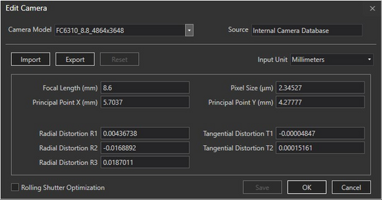
Here are two screen shots from Drone2Map's camera settings. The second image I attached shows the camera models in the program's internal camera database. I believe Drone2Map is built off of the Pix4D mapping engine. You may want to check out Pix4D support documents to see if they say anything about using the Mavic. There are discussions within the drone mapping community regarding the Mavic's rolling shutter camera causing mapping issues. It looks like the camera settings has the rolling shutter optimization option to fix the rolling shutter issue. Just more things to think about...
- Mark as New
- Bookmark
- Subscribe
- Mute
- Subscribe to RSS Feed
- Permalink
- Report Inappropriate Content
Beyond your computer's requirements
System requirements—ArcGIS Drone2Map Help | Documentation
The FAQ for drone to map
Frequently asked questions—ArcGIS Drone2Map Help | Documentation
says
Does ArcGIS Drone2Map work only with a specific type of drone?
ArcGIS Drone2Map is designed to be generic for all drones.
With a few caveats
... sort of retired...
- Mark as New
- Bookmark
- Subscribe
- Mute
- Subscribe to RSS Feed
- Permalink
- Report Inappropriate Content
Mr Patterson,
Thanks!
I didn't realise there will be requirements on the desktop too. Seems reasonable as graphic processing can be demanding, but I'm seated behind an amd ryzen 9 and 24 cores are waiting alongside 32GB ram and a 6GB gpu. I expect no problems there 😉
But it's the 'few caveats' I'm afraid of. Still, since nobody seem to know if it will work or not I'll ask to test the drone for a few weeks and register for a free trial of Drone2Map.
Regards,
Bert
- Mark as New
- Bookmark
- Subscribe
- Mute
- Subscribe to RSS Feed
- Permalink
- Report Inappropriate Content
Here are two screen shots from Drone2Map's camera settings. The second image I attached shows the camera models in the program's internal camera database. I believe Drone2Map is built off of the Pix4D mapping engine. You may want to check out Pix4D support documents to see if they say anything about using the Mavic. There are discussions within the drone mapping community regarding the Mavic's rolling shutter camera causing mapping issues. It looks like the camera settings has the rolling shutter optimization option to fix the rolling shutter issue. Just more things to think about...

