- Home
- :
- All Communities
- :
- Products
- :
- Imagery and Remote Sensing
- :
- Imagery Questions
- :
- Create mosaic dataset from Sentinel 2 level 2A dat...
- Subscribe to RSS Feed
- Mark Topic as New
- Mark Topic as Read
- Float this Topic for Current User
- Bookmark
- Subscribe
- Mute
- Printer Friendly Page
Create mosaic dataset from Sentinel 2 level 2A data
- Mark as New
- Bookmark
- Subscribe
- Mute
- Subscribe to RSS Feed
- Permalink
- Report Inappropriate Content
I have a huge amount of Sentinel 2 level 2A data as downloaded from the Copernicus hub. The data include imagery at 10, 20 and 60 m resolution. In good old ArcMap (10.8) I can access all these data as multispectral imagery by opening the Sentinel XML file and selecting either the 10, 20 or 60 m package. In Pro 2.5 I can just access the 10 m data, having only 4 bands. "Add data" shows all packages referenced in the XML ("BOA Reflectance-20 m" etc.), but - other than ArcMap - they cannot be added.
Not nice, but I can live with that - I have ArcMap. Anyway wondering why that is not implemented in the "modern" Pro environment...
More serious is that neither with ArcMap nor with Pro, I can bring the data to a mosaic dataset. When creating the mosaic dataset, I use the product definition "Sentinel 2 MSI", but later, when trying to add the Sentinel 2 level 2A data, rasters are found but not added. It seems that only Sentinel 2 level 1 data are supported, which is a serious drawback.
Does anyone know a) if this is a general lack (level 2 not supported), or if it is my specific problem?, b) if there is a workaround to open the 20m data in Pro (sure, I can open an individual 20m band as jp2 layer in panchromatic, but that does not help, I need a multispectral layer), c) how I can bring all bands at all resolutions to a mosaic dataset?
Solved! Go to Solution.
Accepted Solutions
- Mark as New
- Bookmark
- Subscribe
- Mute
- Subscribe to RSS Feed
- Permalink
- Report Inappropriate Content
Thomas,
I am sure we get this sortet out with THIS answer 
You have been using the "Add Data" dialog, and, agreed, just checked, there the drop-down to select the processing template to use is not exposed. Here the default method will be used. So the way for you to go is:
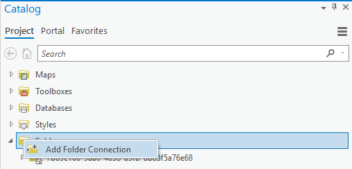
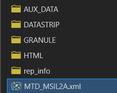
Add the folder with your Sentinel-data to your folder connections in the catalog pane:
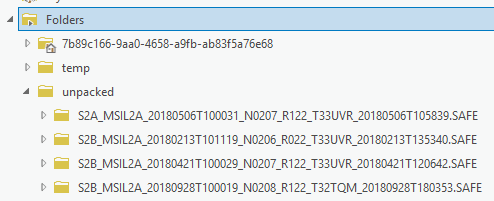
I added a folder with some Sentinel 2a (unpacked version):
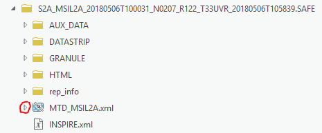
Every single one of them now shows this, when opened:
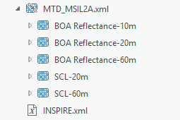
The little arrow pointing out it is extendable:
Up to this point is the solution for your problem No some additional information on this:
If you do the same thing in a "Add Rasters" context of the Mosaic dataset, it will look like this:
When selecting the Raster Type to be Sentinel-2, there will be the drop-down to specify the processing template to use:
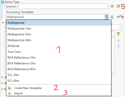
(1) Select the one you want
(2) Or create your own!
(3) Import a (previous saved) one
(4) Edit the one you selected, and export if you want, for later reuse (thats what you would use if you automate with MDCS)
(4) For the one you selected, you can modify and export!
(5) find more relevant settings here, like setting a specific DEM of Orthorectification
We do have routines for 1c "live" from Amazon s3 (thats what we currently use for the Sentinel-Views Services, our Slovak colleagues have published methods on GitHub for 2a from Amazon ... what and how you do it is up to you.
Regards
Guenter
- Mark as New
- Bookmark
- Subscribe
- Mute
- Subscribe to RSS Feed
- Permalink
- Report Inappropriate Content
Thomas,
because of your post I just tried: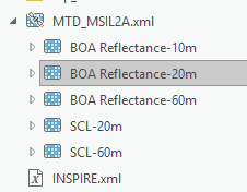
All of those work just fine! Pro 2.5. And regarding the MosaicDatset: Are you aware of the tools we use for automating these workflows and providing more customized versions of Raster Types? The MDCS toolset? GitHub - Esri/mdcs-py: MDCS is an acronym for Mosaic Dataset Configuration Script and is the entry p... Might come in handy for this stuff. We also have versions for Amazon bucket access there. Contact me by mail if you like.
Guenter (gdoerffel-at-esri-dot-com)
- Mark as New
- Bookmark
- Subscribe
- Mute
- Subscribe to RSS Feed
- Permalink
- Report Inappropriate Content
Hi Guenter,
thanks for your feedback! Regarding your screenshot: this is taken from the 2.5 TOC, right? That is exactly what I would love to have! But I don't get it. Maybe I am doing something completely wrong (sorry for that), but what I am doing is:
1. Add a new map
2. Add data -> Data, navigate to the XML. Looks like this:
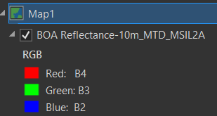
Now I have basically two options: click OK. Then I have the 10m BOA data in my TOC, nothing else:
Or I can double-click the XML, then I see this:
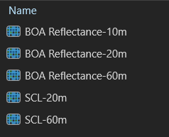
In this list, I can select whatever, and double-click, or click OK, the result is in both cases:

Please let me know how you did that miracle :-). As said, in the same machine with ArcMap 10.8, I can add the different packages:

Thus, it seems the data are ok.
Regarding the MDCS, thanks a lot, I didn't know it, will be the first thing to test tomorrow! And contact you if further questions.
- Mark as New
- Bookmark
- Subscribe
- Mute
- Subscribe to RSS Feed
- Permalink
- Report Inappropriate Content
Thomas,
I am sure we get this sortet out with THIS answer
You have been using the "Add Data" dialog, and, agreed, just checked, there the drop-down to select the processing template to use is not exposed. Here the default method will be used. So the way for you to go is:
Add the folder with your Sentinel-data to your folder connections in the catalog pane:
I added a folder with some Sentinel 2a (unpacked version):
Every single one of them now shows this, when opened:
The little arrow pointing out it is extendable:
Up to this point is the solution for your problem No some additional information on this:
If you do the same thing in a "Add Rasters" context of the Mosaic dataset, it will look like this:
When selecting the Raster Type to be Sentinel-2, there will be the drop-down to specify the processing template to use:
(1) Select the one you want
(2) Or create your own!
(3) Import a (previous saved) one
(4) Edit the one you selected, and export if you want, for later reuse (thats what you would use if you automate with MDCS)
(4) For the one you selected, you can modify and export!
(5) find more relevant settings here, like setting a specific DEM of Orthorectification
We do have routines for 1c "live" from Amazon s3 (thats what we currently use for the Sentinel-Views Services, our Slovak colleagues have published methods on GitHub for 2a from Amazon ... what and how you do it is up to you.
Regards
Guenter
- Mark as New
- Bookmark
- Subscribe
- Mute
- Subscribe to RSS Feed
- Permalink
- Report Inappropriate Content
Dear Guenter,
thank you so much! All fine now. Little bit stupid that I did not figure out by myself. Anyway, thanks a lot for your support!
Thomas
- Mark as New
- Bookmark
- Subscribe
- Mute
- Subscribe to RSS Feed
- Permalink
- Report Inappropriate Content
Guenter/Thomas - have either of you ever been able to access recent Sentinel-2 imagery (newer than 3-days-old) from Esri's Sentinel-2 Views or Sentinel-2 Level-2A imagery services? We've never been able to, even when removing filters/def queries. We are also forced to download tiles instead of leveraging the services when providing timely imagery products. Just wondered if either or you have ever been able to access recent imagery (same AWS-hosted data is available via Sinergise's EO Browser and Copernicus SciHub ~7 hours after acquisition).
- Mark as New
- Bookmark
- Subscribe
- Mute
- Subscribe to RSS Feed
- Permalink
- Report Inappropriate Content
Note that if the MTD.MSILxx.xml does not open as described in the solution it could be that the file path is too long.
Try storing the Sentinel data in root. see:
https://community.esri.com/t5/imagery-and-remote-sensing-questions/why-a-mtd-msil2a-xml-file-does-no...