- Home
- :
- All Communities
- :
- Products
- :
- Imagery and Remote Sensing
- :
- Imagery Questions
- :
- Re: Create DSM OR DTM with Pro OrthoMapping Wizard
- Subscribe to RSS Feed
- Mark Topic as New
- Mark Topic as Read
- Float this Topic for Current User
- Bookmark
- Subscribe
- Mute
- Printer Friendly Page
Create DSM OR DTM with Pro OrthoMapping Wizard
- Mark as New
- Bookmark
- Subscribe
- Mute
- Subscribe to RSS Feed
- Permalink
- Report Inappropriate Content
Hi,
I have a couple of Drones images and Stereo Images and i'm testing the creation of DEM and DSM using the Orthomapping Wizard...
I also created orthomosaic for thoses images and it's seems good ! but with DEM and DSM, i have some problems, the extent of the product that i obtain do not cover all my images extent. I don't know what parameter i can change to obtain a DSM or DTM on the entire extent of my images.
Thanks for help
Asma
- Mark as New
- Bookmark
- Subscribe
- Mute
- Subscribe to RSS Feed
- Permalink
- Report Inappropriate Content
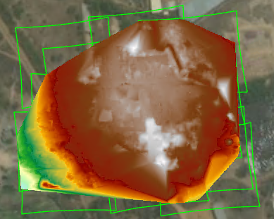
The extent of the output DEM is related to the range of stereo pair angle and overlaps that you define. if the default parameter is not applicable to your data, you can adjust accordingly. For this particular dataset in your screenshot, the image overlaps are small. If you change the minimum overlap from 0.6 (60% by default) to 0.3, the output will cover larger area as below.
Regards,
Hong