- Home
- :
- All Communities
- :
- Products
- :
- Imagery and Remote Sensing
- :
- Imagery Questions
- :
- Re: Convert an Orthomosaic to vector
- Subscribe to RSS Feed
- Mark Topic as New
- Mark Topic as Read
- Float this Topic for Current User
- Bookmark
- Subscribe
- Mute
- Printer Friendly Page
Convert an Orthomosaic to vector
- Mark as New
- Bookmark
- Subscribe
- Mute
- Subscribe to RSS Feed
- Permalink
- Report Inappropriate Content
Greeting
I am Msc student in surveying engineering, I have generated an orthomosaic.tiff (its size 4.5GB) and DTM.tiff (its size 2.5GB) using Pix4D software, I need to making a vectorization to dwg or dxf in order to produce a linemap, I have tried many time to do such conversion using:
AcrToolbox->conversion tools->from raster to ployline, OR raster to polygon.
Unfortunately after a few hours of conversion nothing will display and converted file is empty.
Could you please clarify the procedure if this type of conversion is possible.
- Mark as New
- Bookmark
- Subscribe
- Mute
- Subscribe to RSS Feed
- Permalink
- Report Inappropriate Content
Dear Cody
Still Iam waiting your recommendation based on the posted screenshot.
- Mark as New
- Bookmark
- Subscribe
- Mute
- Subscribe to RSS Feed
- Permalink
- Report Inappropriate Content
Dear Cody
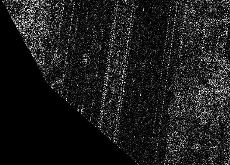
I have performed high-pass filter successfully (as you see in screenshot), after high-pass I have performed raster to polyline/polygon conversion unfortunately no line clear in the output, therefore, could you please instruct me how can I perform edge detection in Arc Map or python? as I understanded from internet searching about edge detection is mostly using python, actually I don't have any knowledge about python.

- Mark as New
- Bookmark
- Subscribe
- Mute
- Subscribe to RSS Feed
- Permalink
- Report Inappropriate Content
Rojgar,
First you can try to convert your DTM into a TIN using (Raster to TIN). After you do that use the (TIN Edge tool) to extract a vector line work of the TIN created from the DTM. This will display a triangular representation of your DTM elevations. Then you export your new line work shapefile to CAD (dwg). As mentioned by Cody if you seeking for elevation contours just run the (contour tool) using your DTM data.
- Mark as New
- Bookmark
- Subscribe
- Mute
- Subscribe to RSS Feed
- Permalink
- Report Inappropriate Content
You have a huge filename issue... Spatial analyst functions generally hate filenames and/or paths with spaces, dashes and are way too long. Try renaming you tif to x.tif or something shorter. As a tip.. generally dont use the c:\users\blah blah folder to do anything. Create your own folder, keep it simple and you will head off problems down the line.
- Mark as New
- Bookmark
- Subscribe
- Mute
- Subscribe to RSS Feed
- Permalink
- Report Inappropriate Content
Dear Dan
I have arranged as you mentioned, unfortunately again failed same error message appeared.
- Mark as New
- Bookmark
- Subscribe
- Mute
- Subscribe to RSS Feed
- Permalink
- Report Inappropriate Content
next... what was your mask? there is a comma somewhere(?) the last message is just the failure error. So check you Environments tab in the tool and see what everything is set to. The final thing would be to check is the checked on ignore nodata option
- Mark as New
- Bookmark
- Subscribe
- Mute
- Subscribe to RSS Feed
- Permalink
- Report Inappropriate Content
Dear Dan
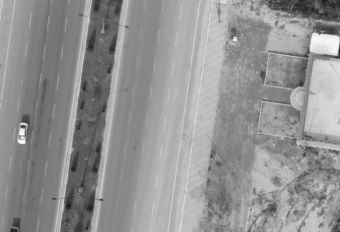
I have performed High-pass filter, related to the mask I have used same raster file which is needed to perform filter on it, high-pass done successfully but converted to the grayscale (as you see in the screenshot).
Currently I got edge enhancement, how can wI perform edge detection (i.e which tool can do edge detection?)
- Mark as New
- Bookmark
- Subscribe
- Mute
- Subscribe to RSS Feed
- Permalink
- Report Inappropriate Content
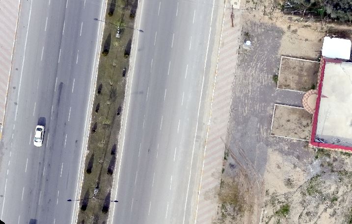
Well it looks like the 3 attached images are the same, which is good. I can see "stuff" a car, a double lane highway a building outlines and some trees... if this originated from lidar data, I would go back to the original data and skip the tiff. Trying to get information like linear features is going to be extremely difficult because of the disconnection between potential segment pieces. You could play with it for days to get something useful, or use Arc-Manual and digitize the features by yourself.
- Mark as New
- Bookmark
- Subscribe
- Mute
- Subscribe to RSS Feed
- Permalink
- Report Inappropriate Content
Hello Rojgar Ismael,
I would suggest using the workflow for Segment Mean Shift tool and the classification tools to create vectors. Here's the link, but it will work in ArcGIS 10.3.1 or Pro. Understanding segmentation and classification—Help | ArcGIS for Desktop
Arthur
- Mark as New
- Bookmark
- Subscribe
- Mute
- Subscribe to RSS Feed
- Permalink
- Report Inappropriate Content
Dear Arthur
Thank you for, actually your link is very useful, I have performed low-class filter before segmentation and classification, unfortunately RGB raster will converting to the Grayscale (as you see in the attached screen shots), could you please clarify how can I keep RGB after filtering?