- Home
- :
- All Communities
- :
- Products
- :
- Imagery and Remote Sensing
- :
- Imagery Questions
- :
- Adding elevation data to a 3 band multiband image
- Subscribe to RSS Feed
- Mark Topic as New
- Mark Topic as Read
- Float this Topic for Current User
- Bookmark
- Subscribe
- Mute
- Printer Friendly Page
Adding elevation data to a 3 band multiband image
- Mark as New
- Bookmark
- Subscribe
- Mute
- Subscribe to RSS Feed
- Permalink
- Report Inappropriate Content
I am new to image processing. I have a three band multiband image. I have a corresponding DEM with elevation data. What is the workflow to transfer the elevation data from the DEM to the three band image, so that the three band image has elevation data attached?
- Mark as New
- Bookmark
- Subscribe
- Mute
- Subscribe to RSS Feed
- Permalink
- Report Inappropriate Content
jay,
In raster processing, it is called 'drape DEM onto image'. To do, the different solution packages of remote sensing differ slightly.
For ArcGIS, you can refer to ArcGIS Desktop
- Mark as New
- Bookmark
- Subscribe
- Mute
- Subscribe to RSS Feed
- Permalink
- Report Inappropriate Content
Are you trying to drape the 3 band image over the DEM (like Larry explains) or do you want to extent the 3 band information to 4 bands (to include the DEM in the multiband raster) to use for instance for classification purposes?
If you want to obtain a multiband raster with 4 band (RGB + DEM) you could use the tool Composite Bands (Data Management). This may require you to convert your DEM to an integer (0-255) range of values.
Kind regards, Xander
- Mark as New
- Bookmark
- Subscribe
- Mute
- Subscribe to RSS Feed
- Permalink
- Report Inappropriate Content
thanks larry and xander. xander, i don't want to drape, i want to the second part of your answer. basically, i have created a basemap jpg of my data that i want to bring into CityEngine. when i bring the image into CE and use the DEM as my height value, i get a really strange looking effect. so, i thought perhaps i could turn my jpeg into a DEM so that the source and the height value are in the same layer, and thus would overlay correctly. thanks again.
- Mark as New
- Bookmark
- Subscribe
- Mute
- Subscribe to RSS Feed
- Permalink
- Report Inappropriate Content
I wonder if that is going to work. Can you include a screenshot of the "strange looking effect"?
- Mark as New
- Bookmark
- Subscribe
- Mute
- Subscribe to RSS Feed
- Permalink
- Report Inappropriate Content
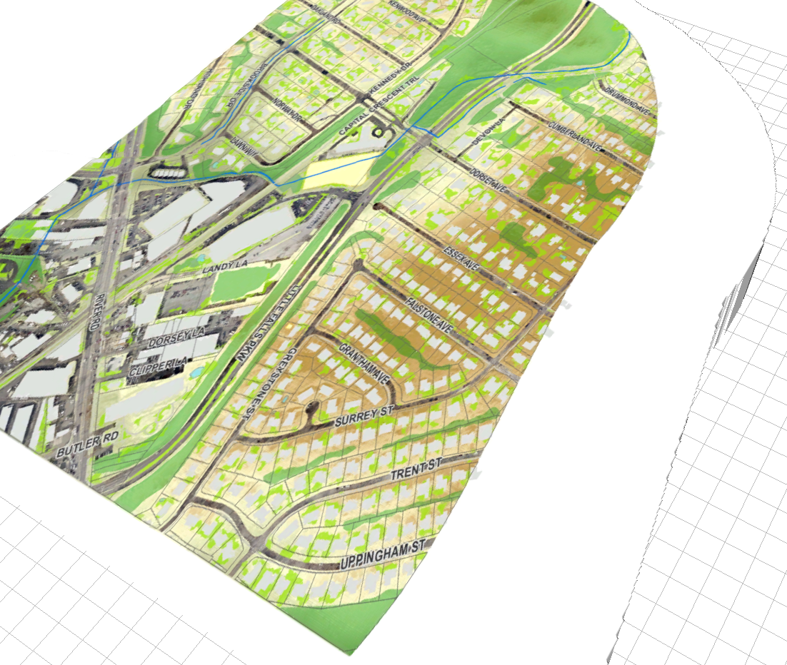
take a look at the screenshot. the image and the DEM were clipped using the same polygon, but they don't seem to be the same size/extent when i drape the image on to the DEM. strange.
- Mark as New
- Bookmark
- Subscribe
- Mute
- Subscribe to RSS Feed
- Permalink
- Report Inappropriate Content
The Drape is required, but applied in CE 2014.1 differently.
Please refer to 'Create the Terrain Layer' from image Help -