- Home
- :
- All Communities
- :
- Products
- :
- Imagery and Remote Sensing
- :
- Imagery Questions
- :
- Re: Receiving Error 000210 when running LAS Datase...
- Subscribe to RSS Feed
- Mark Topic as New
- Mark Topic as Read
- Float this Topic for Current User
- Bookmark
- Subscribe
- Mute
- Printer Friendly Page
Receiving Error 000210 when running LAS Dataset To Raster
- Mark as New
- Bookmark
- Subscribe
- Mute
- Subscribe to RSS Feed
- Permalink
- Report Inappropriate Content
I have downloaded an LAS dataset developed by NOAA for an area of Massachusetts. I am trying to convert this into a DEM I can use to make elevation contours. I have filtered the data so that only ground points are showing. Then, when I try to run the LAS Dataset to Raster tool in ArcGIS Pro 2.3, I receive Error 000210: Cannot create output "filepath".
I have looked at the online help for this error and it looks like a data locking or file path issue. I have closed all other software I had open to make sure something else wasn't locking the data. I have restarted ArcGIS Pro to see if this will help. I have tried saving to a test GDB on my desktop, and the issue still persists.
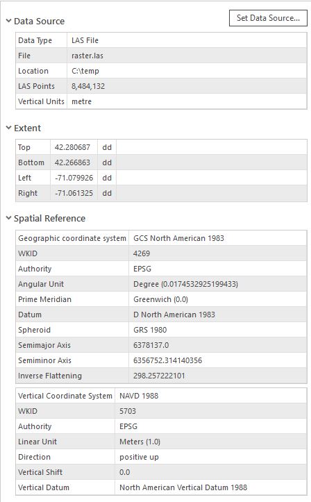
I have included a screenshot of the parameters I'm using for the tool and LAS properties below. Please let me know if there is a solution to this problem.

Kind regards,
David
Solved! Go to Solution.
Accepted Solutions
- Mark as New
- Bookmark
- Subscribe
- Mute
- Subscribe to RSS Feed
- Permalink
- Report Inappropriate Content
Do you have your data in GCS and specified the cellsize of 2. It’s a highly inappropriate cellsize for the data. Assuming this is the problem I’d recommend the las file be projected first (e.g., via the ExtractLAS tool – by setting the output SR in the GP environment for the tool.
- Mark as New
- Bookmark
- Subscribe
- Mute
- Subscribe to RSS Feed
- Permalink
- Report Inappropriate Content
Did you try saving as a *.tif in a folder? seems to be an esri preferred raster format now
- Mark as New
- Bookmark
- Subscribe
- Mute
- Subscribe to RSS Feed
- Permalink
- Report Inappropriate Content
Thanks for the reply. I tried saving as a TIF to a folder and still receive the same error message.
- Mark as New
- Bookmark
- Subscribe
- Mute
- Subscribe to RSS Feed
- Permalink
- Report Inappropriate Content
What is the path then?
is it to a local folder?
try c:\Temp\raster.tif to rule out file and path issue for the destination file... it may be the input that is at issue, although the error suggests otherwise
- Mark as New
- Bookmark
- Subscribe
- Mute
- Subscribe to RSS Feed
- Permalink
- Report Inappropriate Content
I tried saving the input LAS file to C:\Temp and renamed it as input.las, and I chose C:\Temp\raster.tif as the output file, as you suggested. I also restarted my computer before doing this - but I am still receiving the error. I'm surprised none of this has worked.
- Mark as New
- Bookmark
- Subscribe
- Mute
- Subscribe to RSS Feed
- Permalink
- Report Inappropriate Content
Have you tried a shorter output file name or outputting to a tif rather than an ESRI GRID format? The input las filename is also really long - maybe try renaming it to something shorter. Some tools seem to have issues with long paths and/or long names.
Washoe County GIS
- Mark as New
- Bookmark
- Subscribe
- Mute
- Subscribe to RSS Feed
- Permalink
- Report Inappropriate Content
Thanks for the reply. I relocated all of my work to the desktop to shorten the file path, and renamed the LAS files to something shorter (~10 characters). I changed the output name and file type to test.tif. Despite all of this, I am still receiving the same error.
- Mark as New
- Bookmark
- Subscribe
- Mute
- Subscribe to RSS Feed
- Permalink
- Report Inappropriate Content
Hi David,
the first thing to look at would be: Why do you want to export the raster and then make contours? Have you tried creating a MosaicDataset from your data (regardless of las files direct or LAS dataset, and then ...
- Use the contour function to create raster contours
- OR export contours as vectors
Just to make sure there is no general issue, I just ran the tool on a LAS Dataset with a few GIG of LAS in it .... i set the Sampling Value high, though, to be quick. The tool ran smooth. These were my settings (the exclamation makr is because I took the screenshot after the tool finished:
I did not need to set any other environments ... and for output-data naming: Specify the extension and ArcGIS will honor this, if you need more settings, check environment
Regards
Guenter
- Mark as New
- Bookmark
- Subscribe
- Mute
- Subscribe to RSS Feed
- Permalink
- Report Inappropriate Content
Hi Guenter,
I will attempt to make a MosaicDataset and see if that helps. I have tried creating contours directly from the LAS dataset using Surface Contour, but it does not produce results I am happy with (see below screenshots of tool settings and output). I thought creating a raster first, then converting to contours may produce better results.
You will notice that my cell size was set to 2 in my tool settings. To emulate what you ran, I tried running the tool with a cell size of 100 instead, but this did not fix my issue.
Thanks,
David

- Mark as New
- Bookmark
- Subscribe
- Mute
- Subscribe to RSS Feed
- Permalink
- Report Inappropriate Content
And: it would help, if you could take a screenshot of the properties of your LAS-Dataset and the settings you have when running the tool