- Home
- :
- All Communities
- :
- Products
- :
- Imagery and Remote Sensing
- :
- Imagery Questions
- :
- Re: Receiving Error 000210 when running LAS Datase...
- Subscribe to RSS Feed
- Mark Topic as New
- Mark Topic as Read
- Float this Topic for Current User
- Bookmark
- Subscribe
- Mute
- Printer Friendly Page
Receiving Error 000210 when running LAS Dataset To Raster
- Mark as New
- Bookmark
- Subscribe
- Mute
- Subscribe to RSS Feed
- Permalink
- Report Inappropriate Content
I have downloaded an LAS dataset developed by NOAA for an area of Massachusetts. I am trying to convert this into a DEM I can use to make elevation contours. I have filtered the data so that only ground points are showing. Then, when I try to run the LAS Dataset to Raster tool in ArcGIS Pro 2.3, I receive Error 000210: Cannot create output "filepath".
I have looked at the online help for this error and it looks like a data locking or file path issue. I have closed all other software I had open to make sure something else wasn't locking the data. I have restarted ArcGIS Pro to see if this will help. I have tried saving to a test GDB on my desktop, and the issue still persists.
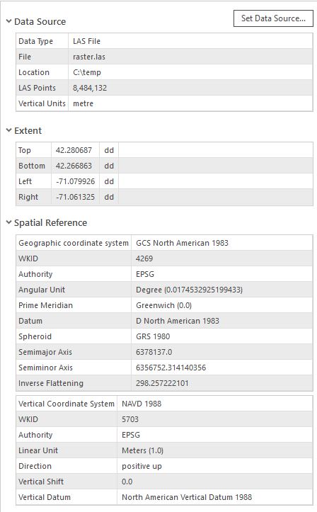
I have included a screenshot of the parameters I'm using for the tool and LAS properties below. Please let me know if there is a solution to this problem.

Kind regards,
David
Solved! Go to Solution.
- Mark as New
- Bookmark
- Subscribe
- Mute
- Subscribe to RSS Feed
- Permalink
- Report Inappropriate Content
Hi Guenter,
I have included screenshots of my tool settings and my LAS dataset properties now.
Regards,
David
- Mark as New
- Bookmark
- Subscribe
- Mute
- Subscribe to RSS Feed
- Permalink
- Report Inappropriate Content
Do you have your data in GCS and specified the cellsize of 2. It’s a highly inappropriate cellsize for the data. Assuming this is the problem I’d recommend the las file be projected first (e.g., via the ExtractLAS tool – by setting the output SR in the GP environment for the tool.
- Mark as New
- Bookmark
- Subscribe
- Mute
- Subscribe to RSS Feed
- Permalink
- Report Inappropriate Content
Hi Vinay,
Thanks for your response. I first used Extract LAS to convert the LAS file to NAD 1983 UTM and now it will convert to a raster.
David
- Mark as New
- Bookmark
- Subscribe
- Mute
- Subscribe to RSS Feed
- Permalink
- Report Inappropriate Content
Thats the advantage of a global company - one goes to sleep - another one takes over: Thanks Vinay and I am glad you solved it!
- Mark as New
- Bookmark
- Subscribe
- Mute
- Subscribe to RSS Feed
- Permalink
- Report Inappropriate Content
Amazing! I had the same problem and it worked!
Can you please place an enhancement and have the error message display something more descriptive.
For example, LASD must be projected in a PCS?
-Marco
- « Previous
-
- 1
- 2
- Next »
- « Previous
-
- 1
- 2
- Next »