- Home
- :
- All Communities
- :
- Products
- :
- Oriented Imagery
- :
- Oriented Imagery Classic
- :
- Re: Projection system and Oriented Imagery Catalog
- Subscribe to RSS Feed
- Mark Topic as New
- Mark Topic as Read
- Float this Topic for Current User
- Bookmark
- Subscribe
- Mute
- Printer Friendly Page
Projection system and Oriented Imagery Catalog
- Mark as New
- Bookmark
- Subscribe
- Mute
- Subscribe to RSS Feed
- Permalink
- Report Inappropriate Content
Hi,
I am trying to create an oriented imagery catalog from a CSV file with the RGF1993 CC49 projection system.
Creating the points works fine, but there is a problem with creating coverage features.
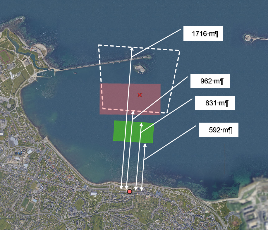
On the screenshot, we can see:
- The green polygon is the one created by the “Create coverage features” tool
- The red polygon appears when clicking on the map to open the oblique photography with the addin “Oriented Imagery”
- The polygon in white dotted lines represents the real polygon of the oblique photography.
I think the problem with the projection system, but I'm not sure.
My ArcGIS Pro version is 2.8.3.
I join my CSV file.
Thank you in advance for your help
.png")
- Mark as New
- Bookmark
- Subscribe
- Mute
- Subscribe to RSS Feed
- Permalink
- Report Inappropriate Content
Matthias
Can you provide more sample data, e.g. your input GPS file, and information about the camera interlock angles? This doesn't seem complete and it's hard to advise. The screenshot you show says "CC49" but the metadata you provided indicates this is image BH75_Nord. Is the red point at the correct location for this exposure? If yes, then this is not a problem with the coordinate system.
Your metadata appears to be from a multi-head oblique camera system - is that correct? Your metadata does not show 4 images at any exposure station (nord, sud, oest and est).
Can you confirm if your flight altitude in your GPS file is referenced to ellipsoidal height or orthometric height?
Cody B
- Mark as New
- Bookmark
- Subscribe
- Mute
- Subscribe to RSS Feed
- Permalink
- Report Inappropriate Content
Hello Cody,
Thank you for your answer.
We will receive the set (10,000 photographs) and the file with the corrections (Omega, Phi, Kappa)
But for now, we only have twelve test images.
Here is the list :
http://www.cuc-cherbourg-sig.net/donnees/vues_obliques_2021/F-AS26_Nord_CAM1.jpg
http://www.cuc-cherbourg-sig.net/donnees/vues_obliques_2021/F-AV75_Est_CAM4.jpg
http://www.cuc-cherbourg-sig.net/donnees/vues_obliques_2021/F-AW49_Ouest_CAM4.jpg
http://www.cuc-cherbourg-sig.net/donnees/vues_obliques_2021/F-AX49_Nord_CAM3.jpg
http://www.cuc-cherbourg-sig.net/donnees/vues_obliques_2021/F-AY50_Sud_CAM3.jpg
http://www.cuc-cherbourg-sig.net/donnees/vues_obliques_2021/F-AZ68_Est_CAM4.jpg
http://www.cuc-cherbourg-sig.net/donnees/vues_obliques_2021/F-BB49_Sud_CAM1.jpg
http://www.cuc-cherbourg-sig.net/donnees/vues_obliques_2021/F-BC39_Ouest_CAM4.jpg
http://www.cuc-cherbourg-sig.net/donnees/vues_obliques_2021/F-BH75_Nord_CAM3.jpg
http://www.cuc-cherbourg-sig.net/donnees/vues_obliques_2021/F-BI18_Ouest_CAM4.jpg
http://www.cuc-cherbourg-sig.net/donnees/vues_obliques_2021/F-BI34_Nord_CAM1.jpg
http://www.cuc-cherbourg-sig.net/donnees/vues_obliques_2021/F-BK18_Sud_CAM3.jpg
The CSV file was created from an Excel workbook
This workbook was created with an import of feature class of points.
My catalog in RGF1993 CC49.
BH75_Nord is only the image's name.
Yes, the red dot is in the right place. I didn't have a problem with the points.
I thought the problem was the projection system because the measurement of NearDist and FarDist on the map is not good (See attachment).
Effectively, there are four images per location (north, south, west and east). Is there a specific setting when it is a multi-head oblique camera system?
The AvgHtAG column indicates the orthometric height in meters above the ground of the camera.
If I load the images with an image list (image with EXIF), the creation of coverage features works fine. But I have the same problem for the consultation.
- Mark as New
- Bookmark
- Subscribe
- Mute
- Subscribe to RSS Feed
- Permalink
- Report Inappropriate Content
Matthias
I'm sorry I misunderstood the "CC49" label in the screenshot - I thought that was an image name but now I understand that is a reference to the coordinate system.
No, there is no specific setting for multi-head camera systems, but I wanted to be sure I understood your data source. And for testing, it would be helpful to have all 4 images from one exposure point, or even better to have 2 or more sequential exposures.
Am I correct that you have no other input data? The ONLY data you have is the image files, where GPS position and camera orientation are recorded only as information embedded in the EXIF tags of the images?
You said "This workbook was created with an import of feature class of points". How was that feature class of points created?
Cody B
- Mark as New
- Bookmark
- Subscribe
- Mute
- Subscribe to RSS Feed
- Permalink
- Report Inappropriate Content
Hi Cody,
Yes, you are right, I have no further data currently.
In EXIF, there is GPS position, orientation, camera, and focal length.
After the shooting mission, our service provider gave us a shapefile with the location of the photographs and the heading of the plane. I used this to create the CSV file.
- Mark as New
- Bookmark
- Subscribe
- Mute
- Subscribe to RSS Feed
- Permalink
- Report Inappropriate Content
Matthias
These images must be captured by a professional camera system - you can continue to experiment with values that you are estimating, but in the end you will want to get more complete data from the service provider. e.g. your table shows CamPitch of 40 degrees for every photo, but I assume that is something you estimated? I expect this camera system must report an accurate Pitch angle. As long as you are estimating values, your results will vary in accuracy. Please try to get a complete set of metadata, and two sequential exposures (4 images in each direction).
Cody B
- Mark as New
- Bookmark
- Subscribe
- Mute
- Subscribe to RSS Feed
- Permalink
- Report Inappropriate Content
Hi Cody B
You are right, the 40 ° CamPitch is theoretical.
It is true if the plane is always horizontal which is often false.
I receive all datas next week.
I'll give it another test and keep you informed.
Matthias
- Mark as New
- Bookmark
- Subscribe
- Mute
- Subscribe to RSS Feed
- Permalink
- Report Inappropriate Content
Hi Cody,
I received my complete dataset with precise indications (pitch, Omega, Phi, Kappa ...)
The creation of the exposure points and the Coverage Map worked well.
But I have a problem with the consultation with the addin.
When I click on the map, I get the message "No image available for the selected location"

I launched the "Analyze Oriented Imagery Catalog" tool, here is the message:
Installed version is the latest version.
Checking for broken paths...
No broken paths found.
Checking for local images and default values...
Local images found! Local Images will only load in the viewer if used by ArcGIS Pro Addin.
Please run the Select Local Images GP Tool to identify the local images.
All mandatory fields have values.
Checking if fields need to be hidden in the feature class...
No need to hide any field.
Checking for coverage features...
Coverage features found.
Checking for vector tile package...
Coverage vector tile package found.
The links to the images are good. The images open with a link from the field "Image" of the exposure points layer from the pop-up window.
I don't understand where the problem comes from.
- Mark as New
- Bookmark
- Subscribe
- Mute
- Subscribe to RSS Feed
- Permalink
- Report Inappropriate Content
Hi Matthias,
This message usually comes when the Max Distance specified in the OIC is not sufficient enough. The max distance does a search in all direction from the point that you have clicked on by the distance specified in this field. You can modify the max distance by using the properties GPTool.
However I would also like to remind you that trying to see the effects of the max distance in the addin will require you to save the project and reload ArcGIS Pro (due to a bug in the addin which is being fixed for the next release.)
Randall
- Mark as New
- Bookmark
- Subscribe
- Mute
- Subscribe to RSS Feed
- Permalink
- Report Inappropriate Content
Hi Matthias,
The issue of the coverage features polygons coming out wrong is due to the values in your table being incorrect.
I made some changes to the table you sent and got polygons that more or less match the white polygon.

I increased the far distance by 1000 and near distance by 500.
There was just guess work and it seemed to have made the difference.
However it would be interesting to know how you arrived at the values that you did.
There is a bug in the current addin where by if you make changes to the values in the attribute table it does not reflect till you restart pro. This happens if you are trying to view your images while you are still editing your OIC.
Randall