- Home
- :
- All Communities
- :
- Products
- :
- Oriented Imagery
- :
- Oriented Imagery Classic
- :
- Re: Projection system and Oriented Imagery Catalog
- Subscribe to RSS Feed
- Mark Topic as New
- Mark Topic as Read
- Float this Topic for Current User
- Bookmark
- Subscribe
- Mute
- Printer Friendly Page
Projection system and Oriented Imagery Catalog
- Mark as New
- Bookmark
- Subscribe
- Mute
- Subscribe to RSS Feed
- Permalink
- Report Inappropriate Content
Hi,
I am trying to create an oriented imagery catalog from a CSV file with the RGF1993 CC49 projection system.
Creating the points works fine, but there is a problem with creating coverage features.
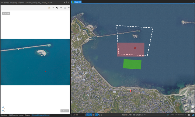
On the screenshot, we can see:
- The green polygon is the one created by the “Create coverage features” tool
- The red polygon appears when clicking on the map to open the oblique photography with the addin “Oriented Imagery”
- The polygon in white dotted lines represents the real polygon of the oblique photography.
I think the problem with the projection system, but I'm not sure.
My ArcGIS Pro version is 2.8.3.
I join my CSV file.
Thank you in advance for your help
- Mark as New
- Bookmark
- Subscribe
- Mute
- Subscribe to RSS Feed
- Permalink
- Report Inappropriate Content
Hi Randall,
I just tried with the given parameters (500 and 1000).
I don't have the same result as you (see screenshot).
Here are the formulas I used to do my calculations:
sensor width = 36 mm
sensor height = 24 mm
focal length = 85 mm
HFOV = 2*atan(sensor width/(2*focal length))
VFOV = 2*atan(sensor height/(2*focal length))
NearDist = AvgHtAG * tan(CamPitch - (VFOV/2))
FarDist = AvgHtAG * tan(CamPitch + (VFOV/2))
- Mark as New
- Bookmark
- Subscribe
- Mute
- Subscribe to RSS Feed
- Permalink
- Report Inappropriate Content
Hi Matthias,
so I checked one of your formulas...
Fardist for image F-BK18_Sud_CAM3
This is the python script I used to calc.
import math
AvgHtAG = 1549.2
CamPitch = 40
VFOV = 16.07142
FarDist = AvgHtAG * math.tan(CamPitch + (VFOV/2))
print (FarDist)
Result : 2000.3470024633373
The value in the sheet you provided was 1721
So somehow we are getting different results. Are you calculating these values in Pro? excel?
Another thing you can check is.. is the camPitch correct?
Also.. After reading what you wrote.. "I just tried with the given parameters (500 and 1000)." and looking at the screen shot.. Did you just change the values in your sheet to 500 and 1000? because I increased the existing values in the excel sheet by those values.. ie.. FarDist was 1721, I increased it to 2721. Similarly with near dist.
- Mark as New
- Bookmark
- Subscribe
- Mute
- Subscribe to RSS Feed
- Permalink
- Report Inappropriate Content
Hi Randall
The math.tan function gives the result of an angle in radians.
If you convert the angle, the result is good :
AvgHtAG = 1549.2
CamPitch = 40
CamPitch = math.radians(CamPitch)
VFOV = 16.07142
VFOV = math.radians(VFOV)
FarDist = AvgHtAG * math.tan(CamPitch + (VFOV/2))
print (FarDist)
Result : 1722.718919169273
I will try the distances you indicate.
- « Previous
-
- 1
- 2
- Next »
- « Previous
-
- 1
- 2
- Next »
