- Home
- :
- All Communities
- :
- Products
- :
- ArcGIS Image Server
- :
- ArcGIS Image Server Questions
- :
- No orthorectification option for Pleiades images.....
- Subscribe to RSS Feed
- Mark Topic as New
- Mark Topic as Read
- Float this Topic for Current User
- Bookmark
- Subscribe
- Mute
- Printer Friendly Page
No orthorectification option for Pleiades images...
- Mark as New
- Bookmark
- Subscribe
- Mute
- Subscribe to RSS Feed
- Permalink
- Report Inappropriate Content
Hello !
I'm working with Pleiades panchromatic images in ArcMap. When I load the DIM file my image appears correctly in my project. But I would like to verify that the RPC's are being taken into account and I would like to use a DEM to orthorectify the image.
If the RPC file is taken into account correctly I should have an orthorectify option in the layer proprieties of my image (display tab). If there is no RPC file found then this option should be grey-out. But for me, the option doesn't even exist.
Any ideas ? Thanks in advance !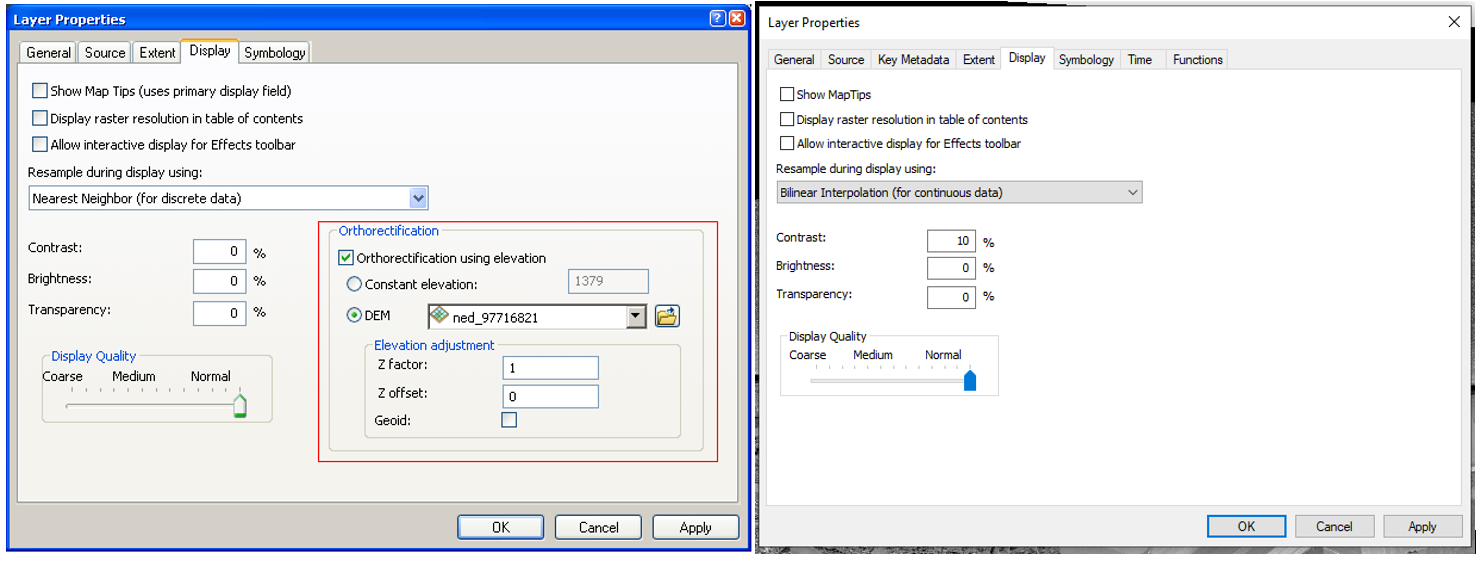
- Mark as New
- Bookmark
- Subscribe
- Mute
- Subscribe to RSS Feed
- Permalink
- Report Inappropriate Content
For raster products such as Pleiades, please use the Geometric function.
You can also use the Orthorectify button from the Image Analyst window.
To access the Orthorecify button, first open the Image Analysis window. 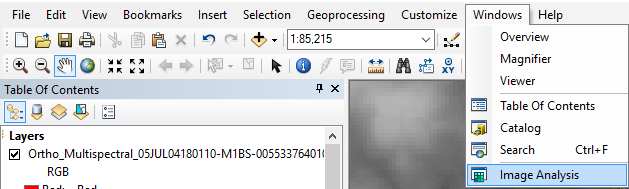
Then in the Image Analysis window, highlight both your Pleiades layer and your DEM. Then click the Orthorectify button.
Now a new Orthorectified layer is in the map. This is a virtual layer, so if you want to persist it, you will need to use the Export button (to the right of Orthorectify).
- Mark as New
- Bookmark
- Subscribe
- Mute
- Subscribe to RSS Feed
- Permalink
- Report Inappropriate Content
Thanks for responding.
I read the documentation stating that if RPCs were correctly read for the image the orthorectification option should appear in the proprieties of the layer. I just wanted to make sure that the lack of this option doesn't mean that the rpc's aren't being read.
But if this doesn't signal a problem I will continue with orthorectification from the image analysis window. Thanks !
- Mark as New
- Bookmark
- Subscribe
- Mute
- Subscribe to RSS Feed
- Permalink
- Report Inappropriate Content
I believe the functionality has been removed, since the Geometric function\Orthorectify button are more accurate. However the documentation may not have been updated with that change unfortunately.
If you are adding your Pleiades as a raster product, then it will have RPCs.
If you want to double check though, you can try the following:
1) Open up the raster layer properties of your raster (in the Table of Contents)
2) On the Functions tab, look for the Geometric function
3) Double click on the Geometric function. And click on the Geodata Transform button.
Here is all the geographic information for the raster product layer.
- Mark as New
- Bookmark
- Subscribe
- Mute
- Subscribe to RSS Feed
- Permalink
- Report Inappropriate Content
Ah ok! That would make sense because my rpc file is definitely there. I was worried that there was a bug. Non-updated documentation could explain everything! Thank you sooooo much for taking the time to respond, I will get to georectifying !
- Mark as New
- Bookmark
- Subscribe
- Mute
- Subscribe to RSS Feed
- Permalink
- Report Inappropriate Content
Zoe,
I highly recommend looking at this workflow and probably testing the free Toolbox offered here:
Managing High-Resolution Satellite Imagery—Imagery Workflows | Documentation
This is based on MosaicDatasets - go for it!
G.
- Mark as New
- Bookmark
- Subscribe
- Mute
- Subscribe to RSS Feed
- Permalink
- Report Inappropriate Content
Thank you for the suggestion. I will take the time to read this documentation and improve my workflow !
- Mark as New
- Bookmark
- Subscribe
- Mute
- Subscribe to RSS Feed
- Permalink
- Report Inappropriate Content
I would also suggest using the Raster Products capability and then edit the function chain. Following in ArcGIS Pro which I would recommend using instead of ArcMap, but similar is available in ArcMap.
In Catalog navigate to the Pleiades scene. The Dim file will appear as a 'product' if you open you can see options such as Multispectral and PanSharpen
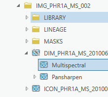
Drag into your map.
Right click on layer and select 'Edit function chain'.
If the scene has an RPC then you will see a geometric function (but so far does not have a DEM)

Use Add Raster icon or drag a DTM from content into function editor and connect to the Geometric function. (Note if you are pansharpening there are two geometeric functions)

In the Geometric properties set the method to 'Use DEM' and if your DEM is orthometric height (eg SRTM) then tick the 'Geoid' option.

If you are working with collections of such imagery then look to use Mosaic Datasets. There are workflows to automate the creation and maintenance of such mosaic datasets see 'Managing High-Resolution Satellite Imagery'
- Mark as New
- Bookmark
- Subscribe
- Mute
- Subscribe to RSS Feed
- Permalink
- Report Inappropriate Content
Ok! This is my first time working with HR satellite imagery. I've never explored the function chain feature! Thank you for the advice !