Turn on suggestions
Auto-suggest helps you quickly narrow down your search results by suggesting possible matches as you type.
Cancel
- Home
- :
- All Communities
- :
- Products
- :
- ArcGIS Image Server
- :
- ArcGIS Image Server Questions
- :
- Image Service / Mosaic Dataset Overview Gaps
Options
- Subscribe to RSS Feed
- Mark Topic as New
- Mark Topic as Read
- Float this Topic for Current User
- Bookmark
- Subscribe
- Mute
- Printer Friendly Page
Image Service / Mosaic Dataset Overview Gaps
Subscribe
6806
10
06-07-2010 06:14 PM
by
Anonymous User
Not applicable
06-07-2010
06:14 PM
- Mark as New
- Bookmark
- Subscribe
- Mute
- Subscribe to RSS Feed
- Permalink
- Report Inappropriate Content
Original User: worstell
We have about 1000 tiled DEMs in GRID format. Each DEM source GRID is in the geographic coordinate system and has overlapping edges (6 pixels) on all sides to ensure that we have no gaps. We are trying to make a seamless mosaic using the new mosaic dataset functionality in ArcGIS 10 and serve them using ArcGIS Server Image Extension. We have 2 problems we cannot seem to resolve.
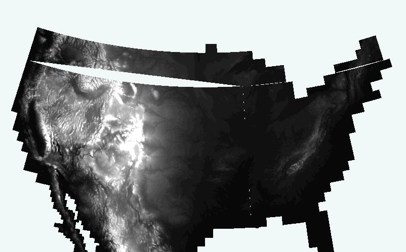
The first problem is with the overviews. Overviews tend to have small sliver gaps along some of the footprint boundaries. If zoomed in far enough, the gaps go away (I assume because the primary raster is being used). When zoomed out, some small gaps seem to show up as shown in the attached image "gap.jpg".
The second problem is related to on-the-fly projection. As noted earlier, the source DEM tiles are in geographic coordinate system and the mosaic dataset was also defined as geographic. On-the-fly projection introduces large gaps at certain scales. The attached graphic "gap-albers.JPG" is a mosiac dataset in geographic that is projected on-the-fly into Albers using ArcMap. These types of artifacts make mosaic datasets unusable for any type of application.
Could someone provide some guidance for troubleshooting mosaic datasets and how to eliminate these gaps?
Thanks
We have about 1000 tiled DEMs in GRID format. Each DEM source GRID is in the geographic coordinate system and has overlapping edges (6 pixels) on all sides to ensure that we have no gaps. We are trying to make a seamless mosaic using the new mosaic dataset functionality in ArcGIS 10 and serve them using ArcGIS Server Image Extension. We have 2 problems we cannot seem to resolve.
The first problem is with the overviews. Overviews tend to have small sliver gaps along some of the footprint boundaries. If zoomed in far enough, the gaps go away (I assume because the primary raster is being used). When zoomed out, some small gaps seem to show up as shown in the attached image "gap.jpg".
The second problem is related to on-the-fly projection. As noted earlier, the source DEM tiles are in geographic coordinate system and the mosaic dataset was also defined as geographic. On-the-fly projection introduces large gaps at certain scales. The attached graphic "gap-albers.JPG" is a mosiac dataset in geographic that is projected on-the-fly into Albers using ArcMap. These types of artifacts make mosaic datasets unusable for any type of application.
Could someone provide some guidance for troubleshooting mosaic datasets and how to eliminate these gaps?
Thanks
10 Replies
by
Anonymous User
Not applicable
09-13-2011
04:07 AM
- Mark as New
- Bookmark
- Subscribe
- Mute
- Subscribe to RSS Feed
- Permalink
- Report Inappropriate Content
Original User: jbswain
Service pack 3 for ArcGIS 10 has not been released yet. Your administrator will know how to create one through the Customer Care Portal.
Service pack 3 for ArcGIS 10 has not been released yet. Your administrator will know how to create one through the Customer Care Portal.
- « Previous
-
- 1
- 2
- Next »
- « Previous
-
- 1
- 2
- Next »