- Home
- :
- All Communities
- :
- Products
- :
- Imagery and Remote Sensing
- :
- Imagery Questions
- :
- how to read NetCDF format data into ArcGIS?
- Subscribe to RSS Feed
- Mark Topic as New
- Mark Topic as Read
- Float this Topic for Current User
- Bookmark
- Subscribe
- Mute
- Printer Friendly Page
- Mark as New
- Bookmark
- Subscribe
- Mute
- Subscribe to RSS Feed
- Permalink
- Report Inappropriate Content
Hello, I have a NetCDF format climate data and would like to ask if anyone know how to convert this format into excel sheet or how to read it into ArcGIS?
Thanks!
Solved! Go to Solution.
Accepted Solutions
- Mark as New
- Bookmark
- Subscribe
- Mute
- Subscribe to RSS Feed
- Permalink
- Report Inappropriate Content
Just downloaded the file and if I use the Make NetCFD Raster Layer tool with default values:
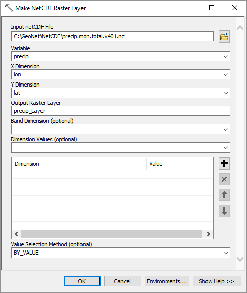
... it creates this raster:
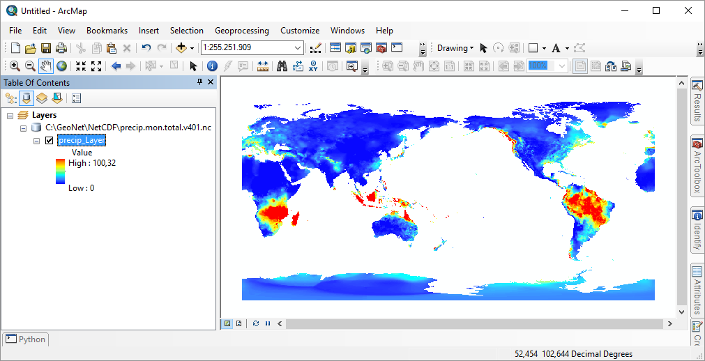
Looks fine to me...
I used 10.3 for this.
- Mark as New
- Bookmark
- Subscribe
- Mute
- Subscribe to RSS Feed
- Permalink
- Report Inappropriate Content
Check the NetCDF Tutorial
Think Location
- Mark as New
- Bookmark
- Subscribe
- Mute
- Subscribe to RSS Feed
- Permalink
- Report Inappropriate Content
In addition to the useful 10.0 link posted by jayanta.poddar you could check out the related help topics of the current version: What is netCDF data?—Help | ArcGIS for Desktop and more specifically Reading netCDF data using geoprocessing tools—Help | ArcGIS for Desktop
- Mark as New
- Bookmark
- Subscribe
- Mute
- Subscribe to RSS Feed
- Permalink
- Report Inappropriate Content
Hello Xander,
Thank you. I read through that and try reading the NetCDF data as a raster layer following ArcGIS's instruction, but it seems does not work. For the input netCDF file, I select my netCDF climate file, then I pick temperature as the variable (the x & y variable are just lon & lat). But when I open the attribute table for the layer I just generate, there is nothing there (and also nothing shows on the map). I wonder whether I do something worng.
Thanks
- Mark as New
- Bookmark
- Subscribe
- Mute
- Subscribe to RSS Feed
- Permalink
- Report Inappropriate Content
Is it possible to share some of your data?
- Mark as New
- Bookmark
- Subscribe
- Mute
- Subscribe to RSS Feed
- Permalink
- Report Inappropriate Content
Hello Xander, thanks for trying to help. May I send the data to you via email? If so, please let me know your email address.
- Mark as New
- Bookmark
- Subscribe
- Mute
- Subscribe to RSS Feed
- Permalink
- Report Inappropriate Content
Hi linyiyi ,
Sorry for the delay. I would prefer that you attach any sample data to this thread. That way multiple users may have a look at it and help solve your problem. If that is not possible for you, you can send me an email with the data to xbakker [at] esri.co (or use for instance WeTransfer if the data is too large to send by email).
- Mark as New
- Bookmark
- Subscribe
- Mute
- Subscribe to RSS Feed
- Permalink
- Report Inappropriate Content
Sure. Please find the attached data file.
Again, thank you so much for your help !
- Mark as New
- Bookmark
- Subscribe
- Mute
- Subscribe to RSS Feed
- Permalink
- Report Inappropriate Content
Hi linyiyi , I am not seeing any file attached. Could you check this please?
- Mark as New
- Bookmark
- Subscribe
- Mute
- Subscribe to RSS Feed
- Permalink
- Report Inappropriate Content
sorry, I just notice the data is too large to send...trying to figure out how to send the data via WeTransfer.