- Home
- :
- All Communities
- :
- Products
- :
- Imagery and Remote Sensing
- :
- Imagery Questions
- :
- Re: Help with oblique imagery - setting up the Cam...
- Subscribe to RSS Feed
- Mark Topic as New
- Mark Topic as Read
- Float this Topic for Current User
- Bookmark
- Subscribe
- Mute
- Printer Friendly Page
Help with oblique imagery - setting up the Cameras table
- Mark as New
- Bookmark
- Subscribe
- Mute
- Subscribe to RSS Feed
- Permalink
- Report Inappropriate Content
Hi,
I would like to test the Oblique viewer sample and for that I need to prepare the Mosaic Dataset and publish it. I have found some sample datasets here: https://www.sensefly.com/drones/example-datasets.html
I have tried the sample called "Oblique imagery"
I created and populated Cameras and Frames tables and created Mosaic Dataset using these tables. Rasters are loaded, but the distortion parameteres seem to be not set up properlly because Footprints looks unreal: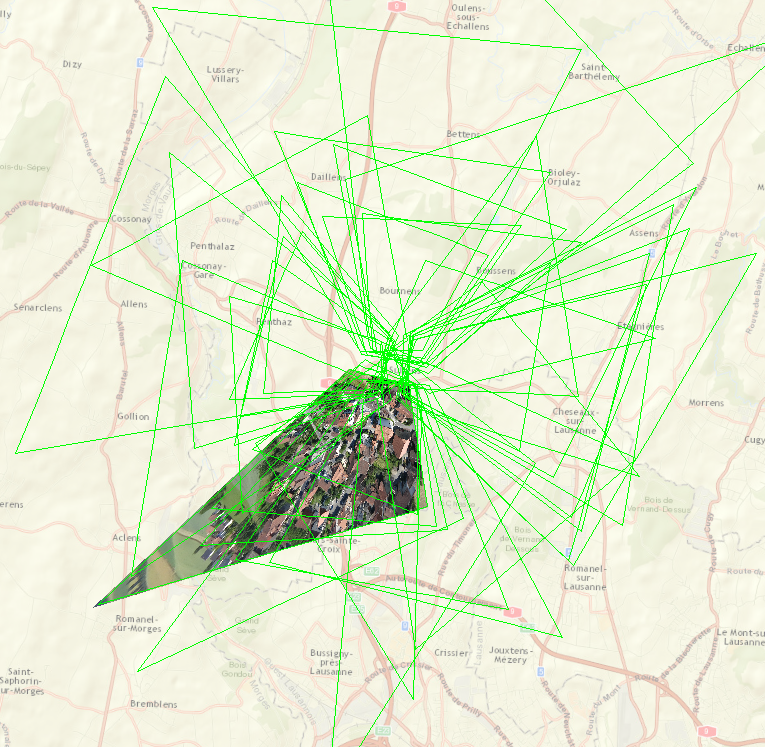
My Camera table looks like:
| OBJECTID | CAMERAID | FOCALLENGTH | PRINCIPALX | PRINCIPALY | A0 | A1 | A2 | B0 | B1 | B2 | SRS | Konrady | DistortionType |
| 1 | [0] | 5387.47722 | -66.313653 | 15.2541 | -3720.169725 | 1.86055 | 0 | 2789.894725 | 0 | -1.8605 | 32632 | 0;-0.00018232164051963605;-5.1623376542584604e-006;1.235913254591796e-007 | Esri-Konrady |
My Frames table sample is:
| OBJECTID | Omega | Phi | Kappa | SRS | CameraID | NCols | NRows | NBands | PixelType | Raster | PerspectiveX | PerspectiveY | PerspectiveZ | |
| 1 | 45.899019 | -7.362863 | 175.289717 | 32632 | [0] | 4000 | 3000 | 3 | 8_BIT_UNSIGNED | ...\IMG_7719.JPG | 313636.698978 | 5162861.933003 | 714.078282 | |
| 2 | 45.912378 | -2.495157 | 171.893432 | 32632 | [0] | 4000 | 3000 | 3 | 8_BIT_UNSIGNED | ...\IMG_7720.JPG | 313643.441509 | 5162858.355595 | 713.06864 |
Can anyone please check my values?
Thanks in advance.
Filip
- Mark as New
- Bookmark
- Subscribe
- Mute
- Subscribe to RSS Feed
- Permalink
- Report Inappropriate Content
Hi Cody and thanks for your answer.
I will explain what i want to achive with the oblique viewer so maybe you can tell me if this is the right solution or not.
I want to create a webapp with oblique images from north-south and east-west with images taken from a drone (DJI RTK) with 45 degree angle.
I want to do simple measurements on the buildings in the images that i view in the webbapp. Is this possible?
If it is, do you have any workflow for this? Where do i begin?
I have arcgis pro advanced with image analyst and access to agisoft metashape and drone2map.
Regards Mattias
- Mark as New
- Bookmark
- Subscribe
- Mute
- Subscribe to RSS Feed
- Permalink
- Report Inappropriate Content
Mattias
sorry I haven't had time to work with you on this. We may need to set up a meeting to discuss details and your objectives (short term and long term).
To start, I would need to be sure what "oblique viewer" you mean. If you're building a Javascript 3x app using this widget ObliqueViewer | API Reference | ArcGIS API for JavaScript 3.33 and Web AppBuilder, note that the focus for the development team is JS 4 in the new Experience Builder. So if this is something you need for long term, we should work in JS 4, but I don't believe an oblique viewer widget exists at this time.
Another key issue is serving the imagery. If you're seeking to use the image coordinate system (ICS) and share a mosaic dataset with the images using the frame camera raster type, you'll need ArcGIS Image Server. (Perhaps you already know that?).
The mosaic dataset that you need is created directly in Drone2Map - the "dynamic mosaic" added in Drone2Map version 2.0 is configured for this purpose (e.g. to use on Image Server to access images using ICS, or to use locally in Pro for viewing in ICS or for stereo viewing with the Image Analyst extension). Note you and I had a previous conversation (May 2019) about the sample script at http://esriurl.com/D2Mmanagement which will also create and configure a mosaic dataset, but as of v2.x this mosaic dataset is created by Drone2Map.
Could you send me an email to discuss?
Cody B.
- « Previous
-
- 1
- 2
- Next »
- « Previous
-
- 1
- 2
- Next »