- Home
- :
- All Communities
- :
- Products
- :
- Imagery and Remote Sensing
- :
- Imagery Questions
- :
- Georeference Question
- Subscribe to RSS Feed
- Mark Topic as New
- Mark Topic as Read
- Float this Topic for Current User
- Bookmark
- Subscribe
- Mute
- Printer Friendly Page
- Mark as New
- Bookmark
- Subscribe
- Mute
- Subscribe to RSS Feed
- Permalink
- Report Inappropriate Content
I am very curious if anyone who have done a lot of georeference projects. Wheather they be old photographs, or the list from this : http://desktop.arcgis.com/en/arcmap/10.5/manage-data/raster-and-images/list-of-supported-raster-and-...
So if you work on them, do you work a lot of control points or just depends on the image itself ?
Would a few control points be sufficient or more than control points is better ?
I wanted to grasp to get the idea of what others are doing with georeference with how many control points out there .
Solved! Go to Solution.
Accepted Solutions
- Mark as New
- Bookmark
- Subscribe
- Mute
- Subscribe to RSS Feed
- Permalink
- Report Inappropriate Content
Hi Robert,
The number of control points required/recommended generally depends on the transformation method used to warp the raster dataset to match the coordinates of the target data. You can find more details about the different transformation methods here:
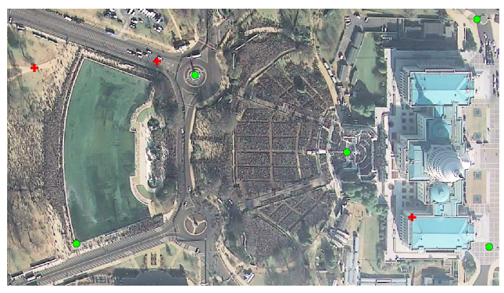
For me, personally, although it can vary depending on the transformation method, raster type, the quality of the data, and other factors, I typically place one point in each "corner" of the raster and one in the middle for a relatively even distribution.
- Mark as New
- Bookmark
- Subscribe
- Mute
- Subscribe to RSS Feed
- Permalink
- Report Inappropriate Content
Hi Robert,
The number of control points required/recommended generally depends on the transformation method used to warp the raster dataset to match the coordinates of the target data. You can find more details about the different transformation methods here:
For me, personally, although it can vary depending on the transformation method, raster type, the quality of the data, and other factors, I typically place one point in each "corner" of the raster and one in the middle for a relatively even distribution.
- Mark as New
- Bookmark
- Subscribe
- Mute
- Subscribe to RSS Feed
- Permalink
- Report Inappropriate Content
Thank you. I hope anyone else can reply and I would like to hear others too...