- Home
- :
- All Communities
- :
- Products
- :
- ArcGIS Drone2Map
- :
- ArcGIS Drone2Map Questions
- :
- Re: Drone2Map for ArcGIS: XML file validation fail...
- Subscribe to RSS Feed
- Mark Topic as New
- Mark Topic as Read
- Float this Topic for Current User
- Bookmark
- Subscribe
- Mute
- Printer Friendly Page
Drone2Map for ArcGIS: XML file validation failed with current XSD
- Mark as New
- Bookmark
- Subscribe
- Mute
- Subscribe to RSS Feed
- Permalink
- Report Inappropriate Content
Hi,
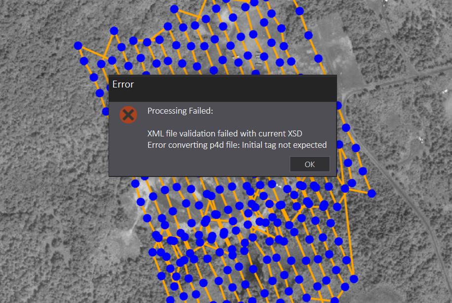
I'm working with Drone2Map for ArcGIS (final release) and I can't get it to process drone imagery that worked in beta. I get the message below that an XML file validation failed:
Odd thing is that the sample data that comes with the software can be processed.
When comparing the underlying .p4d XML files that get generated by Drone2Map I see some minor differences between the sample data and my data but nothing that points to an error.
Anyone got their own imagery to work with Drone2Map for ArcGIS final or have a suggestion to solve this?
Thanks,
Mike
- Mark as New
- Bookmark
- Subscribe
- Mute
- Subscribe to RSS Feed
- Permalink
- Report Inappropriate Content
Mike, I have experienced the same issue. When I transformed my GPS coordinates CSV file from local coordinate system (S-JTSK - 102067) to WGS84, then it worked for me correctly.
- Mark as New
- Bookmark
- Subscribe
- Mute
- Subscribe to RSS Feed
- Permalink
- Report Inappropriate Content
Hi Mike,
The error you are seeing indicates that we are seeing some issues with the project's P4D file. If you use the following workflow, does the error disappear?
1) Run the creation process in Drone2Map, let it fail
2) Close Drone2Map
3) Navigate to the project's process folder: "C:\Users\<USERNAME>\Documents\Drone2Map Projects\<PROJECT>\process"
4) Open the Project's P4D file (<Project>.p4d) in a text editor
5) Remove all of the tags regarding "Yaw", "Pitch", and "Roll". These will be under the ORI tag ( you should be able to find and replace with the following search: <ori.*/> )
6) Save the file
7) Reopen the Project in Drone2Map
😎 Rerun the creation process (accept the overwrite warning)
If this doesn't work, please feel free to open up a tech support case with us so we can take a peek at what may be going on.
Cheers,
Andy
- Mark as New
- Bookmark
- Subscribe
- Mute
- Subscribe to RSS Feed
- Permalink
- Report Inappropriate Content
Thank you Andrew,
A colleague has started working with tech support behind the scenes and they have indicated that there is an issue with the yaw, pitch and roll like you mentioned. I'll give the workaround a try and let you know how it goes.
Mike
- Mark as New
- Bookmark
- Subscribe
- Mute
- Subscribe to RSS Feed
- Permalink
- Report Inappropriate Content
I'm sorry but I have this problem and I can't solution with your indication. Can you help me? My english is very bad but.... Are the problem: images or program?. Thanks for your help
- Mark as New
- Bookmark
- Subscribe
- Mute
- Subscribe to RSS Feed
- Permalink
- Report Inappropriate Content
We are releasing an update to Drone2Map next week that will resolve the issue with imagery containing Yaw, Pitch, and Roll data.
Thanks
Tony
- Mark as New
- Bookmark
- Subscribe
- Mute
- Subscribe to RSS Feed
- Permalink
- Report Inappropriate Content
Tested Drone2Map (1.0.1) today for the first time, and still got this error message. DJI phantom 3 advanced.
- Mark as New
- Bookmark
- Subscribe
- Mute
- Subscribe to RSS Feed
- Permalink
- Report Inappropriate Content
Thanks for taking the time to work with me on this Oddbjørn!
We identified the issue is related to the Region settings applied in windows. For others getting this error, please change your Region format to English (United States) and it should resolve this issue.
We will fix this in the next release.
Thanks,
Tony Mason
Product Manager - Drone2Map
- Mark as New
- Bookmark
- Subscribe
- Mute
- Subscribe to RSS Feed
- Permalink
- Report Inappropriate Content
Hi Tony,
I'm working with Drone2Map (1.0.0.464) in the UK, and am also experiencing this issue, with the same error message:

We have tried the suggestions above, but with no success.
I have changed my computer's region to English (United States), and my project's P4D file doesn't appear to have an ORI tag.
The GPS coordinates of my images are British National Grid (27700), as are the coordinates of my GCP's. Do you think this might be a coordinate system issue? We tried running the same project without defining the coordinate system first(defaulted to WGS84), and seemed to work fine.
Could this be related to the version of the software that we are currently working with?
Thanks,
Claire