- Home
- :
- All Communities
- :
- Products
- :
- Imagery and Remote Sensing
- :
- Imagery Questions
- :
- Bug? FMV multiplexer using wrong elevation in ArcP...
- Subscribe to RSS Feed
- Mark Topic as New
- Mark Topic as Read
- Float this Topic for Current User
- Bookmark
- Subscribe
- Mute
- Printer Friendly Page
Bug? FMV multiplexer using wrong elevation in ArcPro 2.5
- Mark as New
- Bookmark
- Subscribe
- Mute
- Subscribe to RSS Feed
- Permalink
- Report Inappropriate Content
Hi there Cody Benkelman / fellow FMV pioneers
Is anyone else having issues with the 2.5 multiplexer?
I've got UAV data that I have multiplexed fine in ArcPro 2.4, correct location and scale, all good. I've just tested this again one a fresh install of 2.4.2 on another machine.
Now processing in ArcPro 2.5 with the exact same input datasets and it's creating output with wrong corner points / elevation. It would appear to be now projecting the sensor center point down to the WGS84 Geoid rather than the specified DEM.
I'm working over water so I user the DEM value of "0 Meters". However, investigating the issue I also tried creating a constant raster with value of 0 and used that - it also created incorrect results but different to the fixed value..!
Some images below.
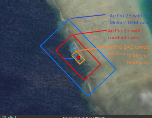
Image 1: FMV outlines
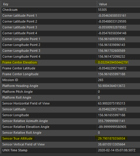
Image 2: Metadata from 2.4 processed video. Note Frame center elevation.

Image 3: Metadata from 2.5 processed video, all variables the same, DEM set at "0 Meters". Frame center elevation has been replaced with Frame Center height above ellipsoid

Image 4: Metadata from 2.5 processed video using a raster with 0 value cells as the DEM.
Any tips appreciated, I it would be pain to shift my flowlines to processing on another machine as I'm using some 2.5 functionality eg notebooks and the FMV Sync Playback.
Cheers, Graham
Solved! Go to Solution.
Accepted Solutions
- Mark as New
- Bookmark
- Subscribe
- Mute
- Subscribe to RSS Feed
- Permalink
- Report Inappropriate Content
Hi Graham,
This is indeed broken in 2.5. It will be fixed in 2.6. Unfortunately, we don't have a fix in time for 2.5.1.
However, there's a workaround. If your map has an elevation source, it will calculate the footprint based on the elevation source in real time, and the incorrect value in the metadata will be ignored. Scene views always have elevation sources. To add an elevation source to a 2D map view, Ribbon -> Map tab -> Layer group -> Add Data dropdown -> Elevation Source. I typically use the Terrain 3D service from Living Atlas.
Let me know how that works for you,
-Nick
- Mark as New
- Bookmark
- Subscribe
- Mute
- Subscribe to RSS Feed
- Permalink
- Report Inappropriate Content
Phew! Thanks for the update Nick Wallingford , that solution does bring my two 2.5 test videos into correct alignment. Will incorporate into my workflow until the fix.