- Home
- :
- All Communities
- :
- Products
- :
- Imagery and Remote Sensing
- :
- Imagery Blog
- :
- Landsat Polar Services Provide a Window into the A...
Landsat Polar Services Provide a Window into the Arctic and Antarctic
- Subscribe to RSS Feed
- Mark as New
- Mark as Read
- Bookmark
- Subscribe
- Printer Friendly Page
- Report Inappropriate Content
 Landsat Polar image services. Intrigued, I opened my email the other day, and was treated to some of the most gorgeous imagery of the Arctic and Antarctic I had ever seen. Not only did the email contain the images you’ll see in this blog, but also links to two new applications I could use to explore the imagery in the regions and easily share it with others.
Let me give you an overview of the two new polar applications, Landsat Arctic and Landsat Antarctic, as I’m sure you are going to want to explore and share the information you find.
Esri’s Landsat Polar Applications
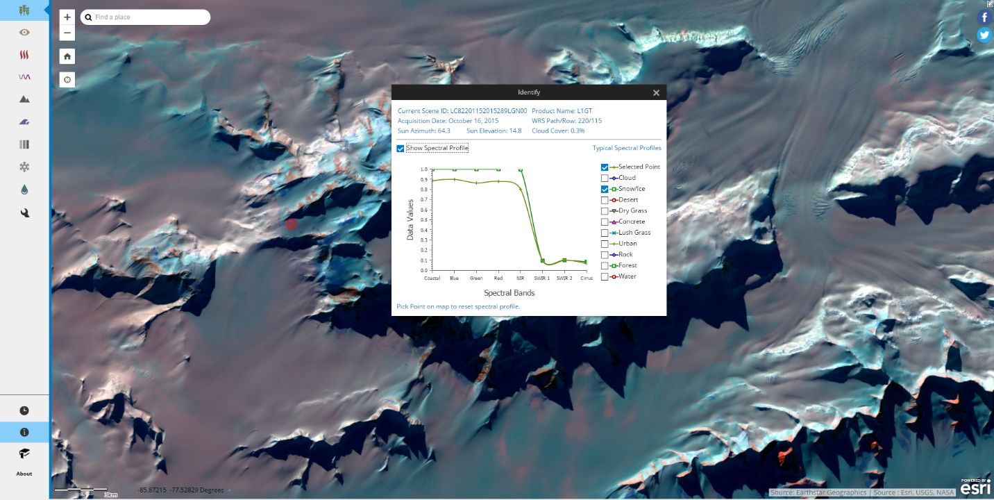 Figure 3: Spectral profile view in Antarctic App
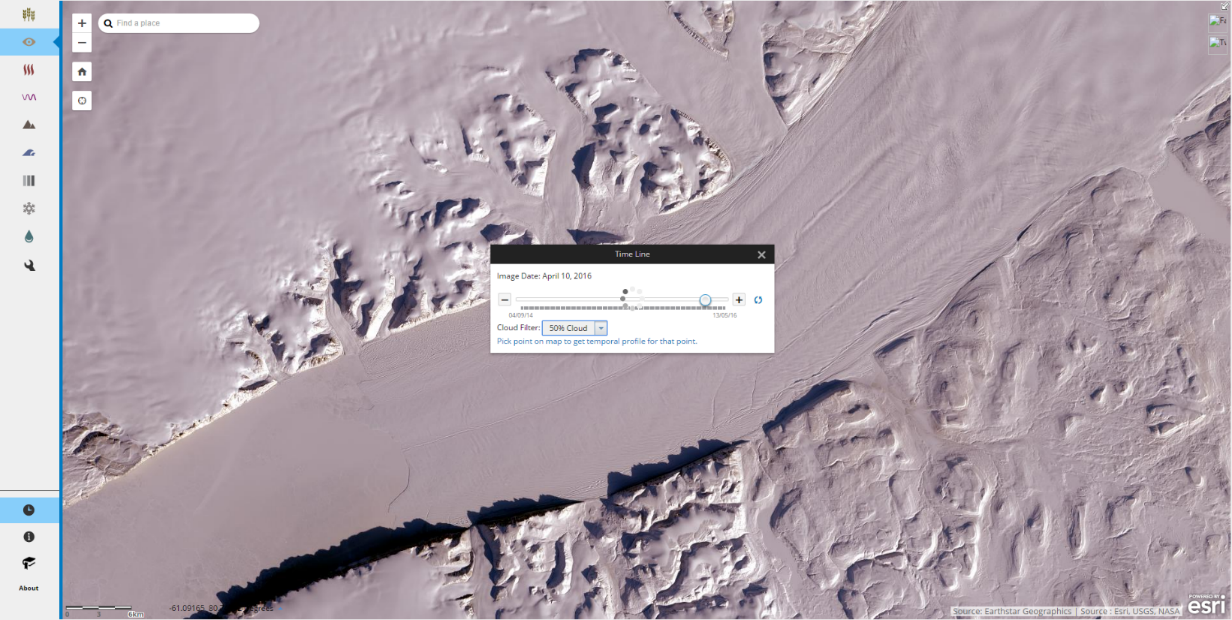
Figure 4: Time tool with cloud filter in Arctic App
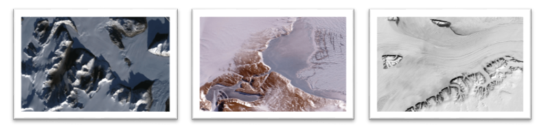
Above, you can see screenshots of the Landsat Arctic and Antarctic applications, and some of the analysis tools built into the application. These applications support both visualization and analysis of the Arctic and Antarctic regions using polar stereographic projections required for working at these latitudes. Using them, you can easily access the latest Landsat polar scenes without the need to store, compile, and process the source data onto your local machine. You have full access to the temporal multispectral, panchromatic, and pan-sharpened Landsat scenes. In addition, you’ll notice the variety of easy to use analysis tools we’ve included in the left hand side of the application. These make it very easy to explore the imagery using custom band combinations, time profiles, and spectral profiles.
- The Spectral profile functionality plots the spectrum of all bands for a desired selected pixel and
- The Time profile provides a scalable timeline with the functionality to filter out clouds, simultaneously.
These applications also include new Facebook and Twitter links. Try them out. When you share the image you are looking at, the shared link will bring a user back to the same location and state of the image analysis that you were at. It’s a great capability for sharing the information and imagery that you find interesting with others.
Landsat Polar Services
The Landsat polar services are available for use within the ArcGIS Online platform and are also part of the Living Atlas. These Landsat services and apps are open for public access. They can be directly used in ArcGIS Pro, ArcGIS for Desktop, ArcGIS Online web and mobile applications, as well as a wide range of applications that utilize the GeoREST Image Services API.
The services are sourced from the scenes that remain in their original UTM projections, but have been published as a services with a default polar projection. All reprojection and mosaicking is being performed on the fly. When viewing them in ArcGIS Online it is optimum to use the Arctic Polar Ocean Basemap / Antarctic Imagery Basemap. Other polar projections may be used within their useful limits.
These services can be used to support the work glaciologists and other scientists want to do in the polar regions including: reducing uncertainties of ice sheet mass balance estimates, providing a streamlined way to investigate associated sea level rise, refinement of ice sheet models, measurement of ice surface displacement/motion, ice-sheet topography, tidal effects over floating ice, ice sheet surface albedo, estimate of surface melt rates, ice velocity, etc.
Accessing the various Polar services
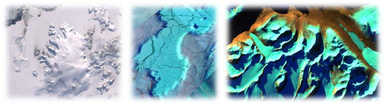
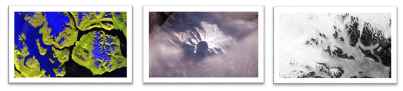
 Figure 1: Arctic Service Figure 2: Antarctic service
(Full view with NDSI Colorized: Blue regions represent snow, water. Yellow-green regions are cloudy, rocky areas.)
The Arctic and Antarctic image services are separate and each is split into multispectral, panchromatic and pansharpened imagery. Currently the services contain all scenes collected since January 2015. In the Arctic, the GLS scenes that cover the Epochs of 2010, 2005, 2000, 1990, 1975 have also been added. The image services are updated daily to add new scenes as soon as they become available. Due to the fact that the Landsat satellite passes over the poles multiple times a day there is extensive temporal coverage. In the summer time when there is light and little cloud there is often a scene every day. Naturally in the winter months there is very little coverage.
Below is a visual representation of each of the 6 different Landsat Polar Services available, along with hyperlinks directing to them.
 Landsat Arctic Views Landsat Arctic Pansharpened Landsat Arctic Panchromatic
 Landsat Antarctic Views Landsat Antarctic Pansharpened Landsat Antarctic Panchromatic
Similar to the Landsat World services, the polar services have various raster functions to render different band combinations and indices like Natural Color with DRA, Geology with DRA, Color Infrared with DRA, Normalized Difference Moisture Index Colorized, and Panchromatic with DRA Sharpened. Two new raster functions Normalized Difference Snow index Colorized and Normalized Difference Snow Index Raw have also been introduced. Similar functions are available for the Antarctic service, as well.
For more information, see the Arctic Maps , Antarctic Maps or Landsat Community groups on ArcGIS Online. You can also access the Landsat World Web App from Unlock Earth’s Secrets.
Data Source
The imagery in these services is sourced from the U.S. Geological Survey (USGS) and the National Aeronautics and Space Administration (NASA). The data for these services reside on the Landsat Public Datasets hosted by Amazon on S3 storage.
You must be a registered user to add a comment. If you've already registered, sign in. Otherwise, register and sign in.
-
Analysis
10 -
ArcGIS Drone2Map
3 -
ArcGIS Excalibur
1 -
ArcGIS Image Analyst
1 -
ArcGIS Image for ArcGIS Online
1 -
ArcGIS Pro
1 -
Change detection
1 -
Deep learning
4 -
Elevation and lidar
8 -
Image classification
1 -
Image management
2 -
Image Mapping
8 -
Image Services
3 -
Mosaic datasets
4 -
Motion imagery
10 -
Multidimensional
2 -
Oriented Imagery
2 -
Raster functions
4 -
Site Scan for ArcGIS
1 -
Visualization
9
- « Previous
- Next »