- Home
- :
- All Communities
- :
- Products
- :
- Geoprocessing
- :
- Geoprocessing Questions
- :
- single-side buffer polygon problem
- Subscribe to RSS Feed
- Mark Topic as New
- Mark Topic as Read
- Float this Topic for Current User
- Bookmark
- Subscribe
- Mute
- Printer Friendly Page
single-side buffer polygon problem
- Mark as New
- Bookmark
- Subscribe
- Mute
- Subscribe to RSS Feed
- Permalink
Hello,

- Mark as New
- Bookmark
- Subscribe
- Mute
- Subscribe to RSS Feed
- Permalink
Are you using projected data? or data in geographic coordinates (aka in decimal degrees)?
Using projected data is preferable to geodesic buffering to unless you are covering an exceptionally large area and to ensure that you have a complete association between the coordinates and euclidean distance you want to buffer. Use the Project tool to produce an appropriate featureclass first, then use
Buffer—Help | ArcGIS for Desktop
there are also other buffer tools
http://www.arcgis.com/home/item.html?id=54ad502f798c4cc780a1132ad44670a9
- Mark as New
- Bookmark
- Subscribe
- Mute
- Subscribe to RSS Feed
- Permalink
What's a one sided polygon?
But, what you have got back is exactly what you asked for.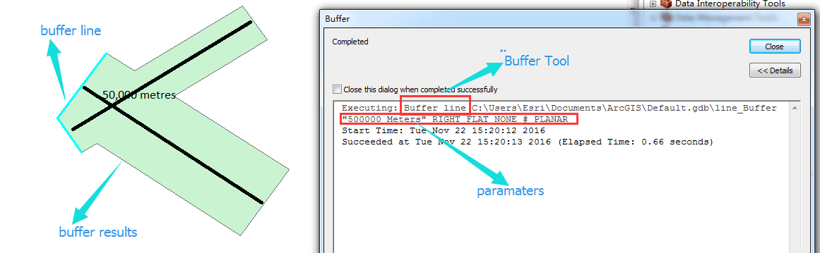
- Mark as New
- Bookmark
- Subscribe
- Mute
- Subscribe to RSS Feed
- Permalink
The results look like both sides of the line were buffered. The results would be different if the line orientations were different. (A one-sided buffer? Can a counter-clockwise ring exist in isolation in a counter-clockwise world? Sounds like the discussions of None and Null)
- Mark as New
- Bookmark
- Subscribe
- Mute
- Subscribe to RSS Feed
- Permalink
Sorry, but no Dan.
The input line is along the far left edge. Each line buffered by 50,000m to the right.
- Mark as New
- Bookmark
- Subscribe
- Mute
- Subscribe to RSS Feed
- Permalink
I see it now... then the result is correct for the given buffer inputs, I thought those lines were your interpretation, they are in fact rectangles intersecting
- Mark as New
- Bookmark
- Subscribe
- Mute
- Subscribe to RSS Feed
- Permalink
I have had many issues with buffering one side of a line (flat or rounded) when there are many lines. I have had several tech support tickets in for this and have never been able to resolve it. For me, I sometimes get a "bubble" on one end, strange "scissor" shapes, polygon/bugger "spikes", etc.
What has helped, but has not eliminated the issues is making sure you have clean geometry
Repair Geometry—Help | ArcGIS for Desktop
Generalizing (i.e. thinning out my my vertices) An overview of the Generalization toolset—Help | ArcGIS for Desktop
and using a cursor to run thru one line/segment at a time and buffer each one separately.
Some of my line segments are loops and/or overlap themselves (not straight segments), and these can cause even more seemingly inconsistent and strange results. Sometimes the buffer is completely within the loop, other times it is within the loop for about 80%, then have a weird spike.
What appears to happen, is rather than just doing the buffer and leaving it "raw", it tries to clean it up and/or generalize the overlap. Typically I would want this (for my project), but because it has these strange results, I wich I could do it myself. But with sometimes 1M+ segments, event he cursor process takes weeks....and although I visually inspect and manually fix some, I know I can't/won't find them all (and haven't found any tool to find these for me).
I'm not showing the lines in this clip, but this is just a sample of some issues I have had


