Turn on suggestions
Auto-suggest helps you quickly narrow down your search results by suggesting possible matches as you type.
Cancel
- Home
- :
- All Communities
- :
- Products
- :
- Geoprocessing
- :
- Geoprocessing Questions
- :
- NoData in between rasters appears after being clip...
Options
- Subscribe to RSS Feed
- Mark Topic as New
- Mark Topic as Read
- Float this Topic for Current User
- Bookmark
- Subscribe
- Mute
- Printer Friendly Page
NoData in between rasters appears after being clipped?
Subscribe
05-29-2013
05:35 AM
- Mark as New
- Bookmark
- Subscribe
- Mute
- Subscribe to RSS Feed
- Permalink
- Report Inappropriate Content
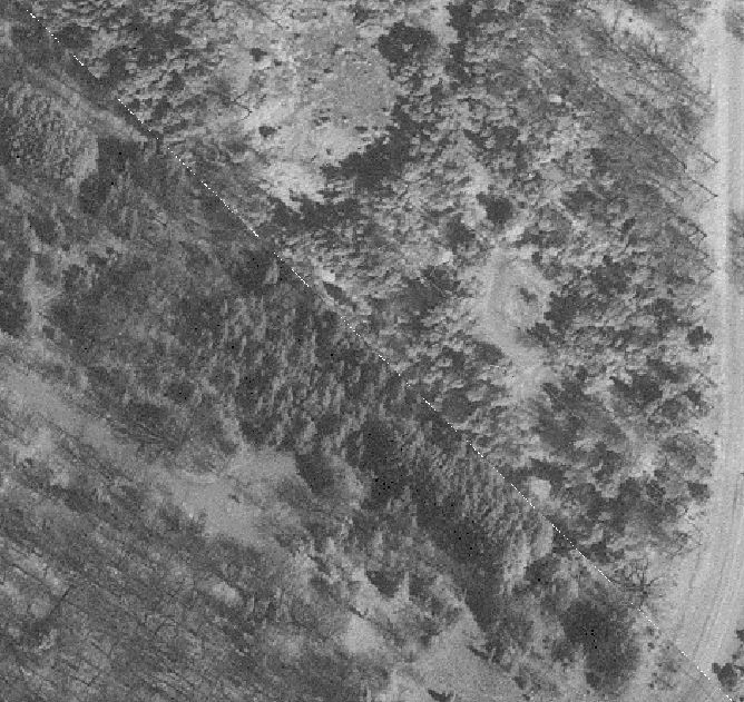
Using the Raster processing Clip tool, I have clipped two TIF rasters. NoData dotted strips are found in between. The rasters prior to being clipped have data in these areas. See screenshot for an overview.
Has anyone have inside regarding this issue?
Thanks for viewing.
[ATTACH=CONFIG]24766[/ATTACH]
Has anyone have inside regarding this issue?
Thanks for viewing.
[ATTACH=CONFIG]24766[/ATTACH]
Solved! Go to Solution.
1 Solution
Accepted Solutions
by
Anonymous User
Not applicable
05-29-2013
07:57 AM
- Mark as New
- Bookmark
- Subscribe
- Mute
- Subscribe to RSS Feed
- Permalink
- Report Inappropriate Content
The clip tool does this to me often as well. I think this happens because the raster cells would not perfectly align with your polygon boundaries (it is likely the line goes through the middle or partly through cells of the raster). Therefore, when the rasters overlap, I believe the clip tool will discard those cells that go past the boundary.
An ugly solution would be have the polygons slightly overlapping (by a tolerance of at least the cell size of the raster). So if your cell size is 10 meters, you could just buffer all your polygons by 10 m (or 20 to be safe) so that whenever you run the clip tool, since the polygons will slightly overlap there *should* be no missing values between the rasters after the clip is done since they will slightly overlap themselves.
I'm willing to bet that someone else out there has a better solution. If so I would be interested in the workflow. This should do it though.
2 Replies
by
Anonymous User
Not applicable
05-29-2013
07:57 AM
- Mark as New
- Bookmark
- Subscribe
- Mute
- Subscribe to RSS Feed
- Permalink
- Report Inappropriate Content
The clip tool does this to me often as well. I think this happens because the raster cells would not perfectly align with your polygon boundaries (it is likely the line goes through the middle or partly through cells of the raster). Therefore, when the rasters overlap, I believe the clip tool will discard those cells that go past the boundary.
An ugly solution would be have the polygons slightly overlapping (by a tolerance of at least the cell size of the raster). So if your cell size is 10 meters, you could just buffer all your polygons by 10 m (or 20 to be safe) so that whenever you run the clip tool, since the polygons will slightly overlap there *should* be no missing values between the rasters after the clip is done since they will slightly overlap themselves.
I'm willing to bet that someone else out there has a better solution. If so I would be interested in the workflow. This should do it though.
An ugly solution would be have the polygons slightly overlapping (by a tolerance of at least the cell size of the raster). So if your cell size is 10 meters, you could just buffer all your polygons by 10 m (or 20 to be safe) so that whenever you run the clip tool, since the polygons will slightly overlap there *should* be no missing values between the rasters after the clip is done since they will slightly overlap themselves.
I'm willing to bet that someone else out there has a better solution. If so I would be interested in the workflow. This should do it though.
05-30-2013
09:28 AM
- Mark as New
- Bookmark
- Subscribe
- Mute
- Subscribe to RSS Feed
- Permalink
- Report Inappropriate Content
The clip tool does this to me often as well. I think this happens because the raster cells would not perfectly align with your polygon boundaries (it is likely the line goes through the middle or partly through cells of the raster). Therefore, when the rasters overlap, I believe the clip tool will discard those cells that go past the boundary.
An ugly solution would be have the polygons slightly overlapping (by a tolerance of at least the cell size of the raster). So if your cell size is 10 meters, you could just buffer all your polygons by 10 m (or 20 to be safe) so that whenever you run the clip tool, since the polygons will slightly overlap there *should* be no missing values between the rasters after the clip is done since they will slightly overlap themselves.
I'm willing to bet that someone else out there has a better solution. If so I would be interested in the workflow. This should do it though.
If using Photoshop, I will get exactly what I want. The Clip tool itself can be the problem. I tried to trace the cell boundary at a scale close to 1:5 to create a boundary polygon and use that to clip a raster. It didn't cut the way as expected. Allowing a buffer of overlap seems to be a workaround for now.