Turn on suggestions
Auto-suggest helps you quickly narrow down your search results by suggesting possible matches as you type.
Cancel
- Home
- :
- All Communities
- :
- Products
- :
- Geoprocessing
- :
- Geoprocessing Questions
- :
- Re: 'LUnit_meters' - What is it?
Options
- Subscribe to RSS Feed
- Mark Topic as New
- Mark Topic as Read
- Float this Topic for Current User
- Bookmark
- Subscribe
- Mute
- Printer Friendly Page
'LUnit_meters' - What is it?
Subscribe
790
2
04-09-2014 11:16 AM
04-09-2014
11:16 AM
- Mark as New
- Bookmark
- Subscribe
- Mute
- Subscribe to RSS Feed
- Permalink
- Report Inappropriate Content
Hello All,
I am processing some geo-referenced historic aerials images in ERDAS Imagine. These are in;
NAD_1983_UTM_Zone_18N
WKID: 26918 Authority: EPSG
However when I process them (without any changes to the coordinate system) they come out as:
LUnits_meters
Authority: Custom
In ERDAS Imagine these are described as:
UTM NAD83 Zone18
[ATTACH=CONFIG]32980[/ATTACH]
Any help is greatly appreciated.
-Samuel
2 Replies
04-09-2014
11:46 AM
- Mark as New
- Bookmark
- Subscribe
- Mute
- Subscribe to RSS Feed
- Permalink
- Report Inappropriate Content
If you're asking what that LUnits_meters means, my guess is it's simply telling you its UTM native coordinates (which are projected) are in linear units of meters. The esri WKT (well-known-text) for this spatial ref includes the datum/projection info - the last param shows the linear unit of meters:
PROJCS["NAD_1983_UTM_Zone_18N",
GEOGCS["GCS_North_American_1983",DATUM["D_North_American_1983",SPHEROID["GRS_1980",6378137,298.257222101]],
PRIMEM["Greenwich",0],
UNIT["Degree",0.017453292519943295]],
PROJECTION["Transverse_Mercator"],
PARAMETER["latitude_of_origin",0],
PARAMETER["central_meridian",-75],
PARAMETER["scale_factor",0.9996],
PARAMETER["false_easting",500000],
PARAMETER["false_northing",0],
UNIT["Meter",1]]
http://spatialreference.org/ref/epsg/nad83-utm-zone-18n/
Not sure I understand if that is what you mean to ask?
04-09-2014
12:00 PM
- Mark as New
- Bookmark
- Subscribe
- Mute
- Subscribe to RSS Feed
- Permalink
- Report Inappropriate Content
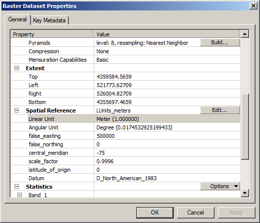
Below is the complete description:
---------------------------------------------------------------------------------------------
LUnits_meters
Authority: Custom
Projection: Transverse_Mercator
false_easting: 500000.0
false_northing: 0.0
central_meridian: -75.0
scale_factor: 0.9996
latitude_of_origin: 0.0
Linear Unit: Meter (1.0)
Geographic Coordinate System: GCS_North_American_1983
Angular Unit: Degree (0.0174532925199433)
Prime Meridian: Greenwich (0.0)
Datum: D_North_American_1983
Spheroid: GRS_1980
Semimajor Axis: 6378137.0
Semiminor Axis: 6356752.314140356
Inverse Flattening: 298.257222101
----------------------------------------------------------------------------------------------------------------------
It is somehow in the Custom Projection, Below graphics:
[ATTACH=CONFIG]32986[/ATTACH]
[ATTACH=CONFIG]32987[/ATTACH]
I do not see the EPSG code in the description. But ERDAS Imagine displays the EPSG code (as well as the coordinate information)
Thanks,
Samuel