Turn on suggestions
Auto-suggest helps you quickly narrow down your search results by suggesting possible matches as you type.
Cancel
- Home
- :
- All Communities
- :
- Products
- :
- Geoprocessing
- :
- Geoprocessing Questions
- :
- Re: How to convert GCS_WGS_1984 to WGS 84
Options
- Subscribe to RSS Feed
- Mark Topic as New
- Mark Topic as Read
- Float this Topic for Current User
- Bookmark
- Subscribe
- Mute
- Printer Friendly Page
How to convert GCS_WGS_1984 to WGS 84
Subscribe
18134
3
03-05-2012 05:47 AM
03-05-2012
05:47 AM
- Mark as New
- Bookmark
- Subscribe
- Mute
- Subscribe to RSS Feed
- Permalink
- Report Inappropriate Content
Does any one how to convert
original system
Geographic Coordinate System: GCS_WGS_1984
Datum: D_WGS_1984
Prime Meridian: Greenwich
Angular Unit: Degree
to
target system
Projected Coordinate System: WGS 84 / UTM zone 54N
Projection: Transverse_Mercator
false_easting: 500000.00000000
false_northing: 0.00000000
central_meridian: 141.00000000
scale_factor: 0.99960000
latitude_of_origin: 0.00000000
Linear Unit: m
Geographic Coordinate System: WGS 84
Datum: World Geodetic System 1984
Prime Meridian: Greenwich
Angular Unit: degree
I used the Projected Coordinate System: WGS_1984_UTM_Zone_54N. The results is pasted as below. However, it doesn't line up with the shapfile which has the targeted system.
Projected Coordinate System: WGS_1984_UTM_Zone_54N
Projection: Transverse_Mercator
False_Easting: 500000.00000000
False_Northing: 0.00000000
Central_Meridian: 141.00000000
Scale_Factor: 0.99960000
Latitude_Of_Origin: 0.00000000
Linear Unit: Meter
Geographic Coordinate System: GCS_WGS_1984
Datum: D_WGS_1984
Prime Meridian: Greenwich
Angular Unit: Degree
I'd appreciate any help you might give me.
Jennie
3 Replies
03-05-2012
07:10 AM
- Mark as New
- Bookmark
- Subscribe
- Mute
- Subscribe to RSS Feed
- Permalink
- Report Inappropriate Content
To answer your explicit question: One does it using the Project tool.
ArcToolbox > Data management Tools > Projections and Transformations > Feature > Project
To trouble shoot your issue, it might help to more precisely define "not lining up".
Have you tried going the other way (UTM to geographic)? That might throw some light on matters.
Some times an incorrect UTM zone has been specified somewhere, which can look confusing if one does not know what that looks like...
03-05-2012
09:24 AM
- Mark as New
- Bookmark
- Subscribe
- Mute
- Subscribe to RSS Feed
- Permalink
- Report Inappropriate Content
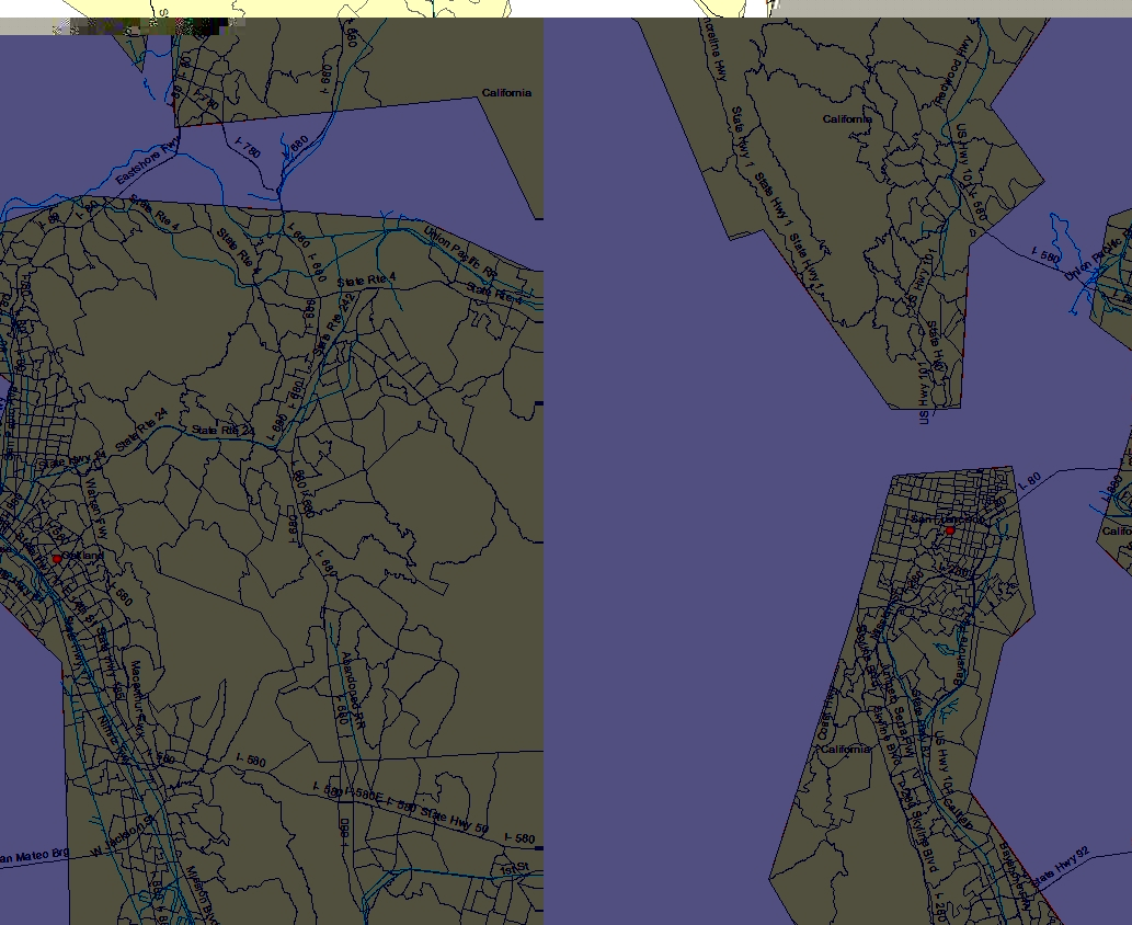
The best advice i can give you is check on what kind of coordinate system you are importing the points/shapefile to, i have ran into this problem many times. With the picture i have provided gives a better idea of how with even the right kind of coordinate system clipping can not solve. When you say that they are "not lining up" how far would they exactly be? a state away? or a city away? if they are very close to each other the clipping tool might be of some help. Hope this might have helped you out some into answering your question.
03-05-2012
09:30 AM
- Mark as New
- Bookmark
- Subscribe
- Mute
- Subscribe to RSS Feed
- Permalink
- Report Inappropriate Content
Thank you the above replies. I just found out the original shapefile is incorrected created. Therefore, the shift (not lining up) with the target shapefile is not solvable by convertting coordinates system.
My new questions is, how to line up the UTM 54N shapefile with a 500m grid map generated based on latitude and longitude?
I'd appreciate any help you might give me.
Jennie
My new questions is, how to line up the UTM 54N shapefile with a 500m grid map generated based on latitude and longitude?
I'd appreciate any help you might give me.
Jennie