- Home
- :
- All Communities
- :
- Products
- :
- Geoprocessing
- :
- Geoprocessing Questions
- :
- Re: Generalisation whilst keeping fill
- Subscribe to RSS Feed
- Mark Topic as New
- Mark Topic as Read
- Float this Topic for Current User
- Bookmark
- Subscribe
- Mute
- Printer Friendly Page
Generalisation whilst keeping fill
- Mark as New
- Bookmark
- Subscribe
- Mute
- Subscribe to RSS Feed
- Permalink
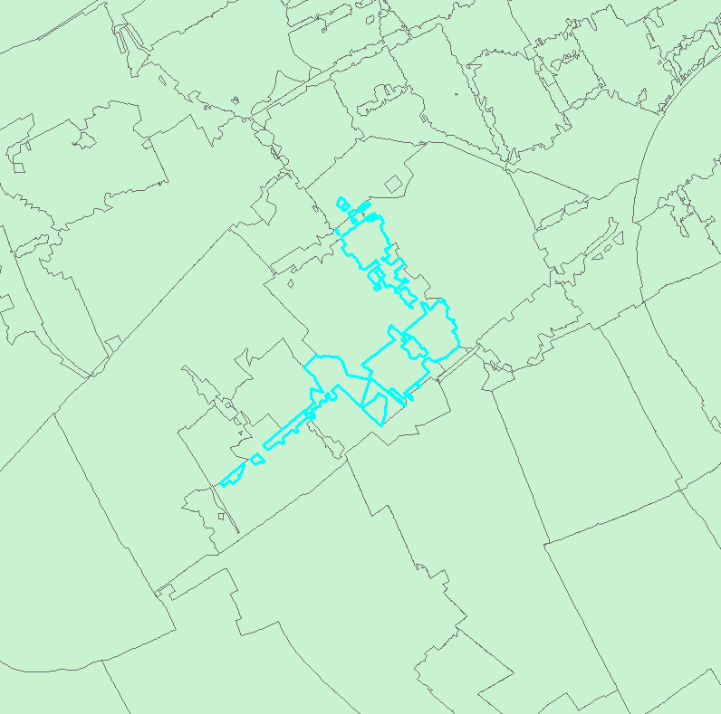
I have dissolved six position postal code areas (~ street part level) to create four position postal code areas (~ neighbourhoud level). Naturally, this has resulted in some strange shapes and multipart features (see below; selected area is a single feature).
I want to generalise these features and make them singlepart features, without losing the fact that the individual shapes share boundaries. Is there a way to do this?
- Mark as New
- Bookmark
- Subscribe
- Mute
- Subscribe to RSS Feed
- Permalink
I already did, and it doesn't. I need singlepart features, but I want them to be simplified versions of the current features, whilst making sure that full coverage is retained.
- Mark as New
- Bookmark
- Subscribe
- Mute
- Subscribe to RSS Feed
- Permalink
I don't know how many postal codes you have, but what type of symbology did you try for the undissolved version? Does your table reflect the fact that do indeed share the same postal code? Have you explored the ability to classify your symbology on multiple fields or to draw layers by combining categories? Further information would be useful for your desired output... in the interim, check this link
- Mark as New
- Bookmark
- Subscribe
- Mute
- Subscribe to RSS Feed
- Permalink
So, to hopefully make my problem a little more clear: I want to do a sort of combination of Multipart to Singlepart, Thiessen polygons and generalization is what I need; if possible. And I want to actually save the results of this operation to a new dataset, not let them be a representation of the data.
I hope this clarifies things! If not, please ask.
- Mark as New
- Bookmark
- Subscribe
- Mute
- Subscribe to RSS Feed
- Permalink
Marten...you had me right up until you said Thiessen why not mark up your original with a visual of what you want. I am beginning to think along the lines of extent rectangles or something similar. Also what do you to do with the areas that you will obliterate if the output shape changes, or do you only want it for this one feature. Or perhaps you want a concave hull (no standardly available)
- Mark as New
- Bookmark
- Subscribe
- Mute
- Subscribe to RSS Feed
- Permalink
Will do that. I will post this later today, as I don't have the possibility to do this at my current location.
- Mark as New
- Bookmark
- Subscribe
- Mute
- Subscribe to RSS Feed
- Permalink
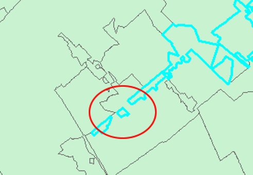
Hi Marten,
If the parts in the 4PPC feature should be merged into 1 part, and since 4PPC areas may not overlap, wouldn´t this create other "multiparts" (split other features) as shown below?
Maybe the Aggregate Polygons (Cartography, advanced license required) is worth giving a try...
- Mark as New
- Bookmark
- Subscribe
- Mute
- Subscribe to RSS Feed
- Permalink
So, I've drawn my idea of the solution: mutually exclusive generalised singlepart postal code areas that fill the entire area. I know my Paint-skills aren't all that, but I hope it illustrates my thinking a bit better. I must also add that I want the resulting areas to have roughly the same area as the original areas. However, as you can see in my picture, I am willing to accept quite a lot of generalisation.
Please let me know if there is anything else that I can do to explain my problem better.
.png)
- Mark as New
- Bookmark
- Subscribe
- Mute
- Subscribe to RSS Feed
- Permalink
well...I can honestly think of no algorithm that would produce that layout even with sharpened lines etc. If the intent is to redistribute postal codes from scratch, then you could look into spatial allocation options or at least a Delaunay triangulation or Voronoi diagram would look attractive, even some network analyst allocation might be useful if drive times were important. Initially, it was six but I am seeing a massive number of fiddly bits which I am attributing to drawing. If it is truly only six, editing manually would be the quickest. Good luck. Perhaps, some of the mathematicians over at the Mathematics Stack Exchange site or the stats people over at SE's Cross-Validated site might have a different perspective unclouded by GIS. Good luck