- Home
- :
- All Communities
- :
- Products
- :
- Geoprocessing
- :
- Geoprocessing Questions
- :
- Re: Arcgis very slow
- Subscribe to RSS Feed
- Mark Topic as New
- Mark Topic as Read
- Float this Topic for Current User
- Bookmark
- Subscribe
- Mute
- Printer Friendly Page
Arcgis very slow
- Mark as New
- Bookmark
- Subscribe
- Mute
- Subscribe to RSS Feed
- Permalink
- Report Inappropriate Content
Hello!
Does anyone know how I can speed up the process Join Space ?. On my machine it has taken too long.
This is my setup
i5 3.0 GHz
8GB RAM
thanks
- Mark as New
- Bookmark
- Subscribe
- Mute
- Subscribe to RSS Feed
- Permalink
- Report Inappropriate Content
I followed the tip of all the comments.
1º
I created a geodabase with data
Added 4 shapes of polygons (countries, states, cities and districts of South America)
1 and the shape points (observation species)
2º
Join realized the Space as follows:
Analysis Tool-> overlay-> space join-> one to many
I think there is a difference in saving the job in the default output <inside geodatabase>,> takes longer to save in another way <another folder>
I realized that saving in another output <inside another folder> is faster. Only for some reason the ArcGIS is giving an error. This NEVER happened 
He makes the table, but fails to display the map
As for time, it is almost the same thing! Tthe process is running forever.
Thus I modified the way cross data
Add the two shapes (polygons and points) on the desktop: right click (on top of the points layer) -> join and Relates
These methods are equivalent?
Thank you again!
- Mark as New
- Bookmark
- Subscribe
- Mute
- Subscribe to RSS Feed
- Permalink
- Report Inappropriate Content
Joyce, your geodatabase should be close to the root of your C drive, for example: C:\GIS_folder\test.gdb, and of course your shapefiles should all have the same projection.
Spatial Join joins the data by the location--one feature overlaps a feature in the other class, for instance.
Joins/relates joins data by a common field, such as a name or ID that is the same in each class.
So, they are not really the same--it depends what relates your two tables. If they are not related by location, then you should definitely use join/relate.
You are working with huge tables, as you said, so a spatial join will take a while.
- Mark as New
- Bookmark
- Subscribe
- Mute
- Subscribe to RSS Feed
- Permalink
- Report Inappropriate Content
See this is the file I'm working on:
https://www.dropbox.com/sh/b5bi24m8qjlyc5t/AAB-LY57CgAj0slEvljUzNk7a?dl=0
This file is in this directory: C: \ arc
- Mark as New
- Bookmark
- Subscribe
- Mute
- Subscribe to RSS Feed
- Permalink
- Report Inappropriate Content
I followed this tutorial:GIS Tutorial: How to perform a spatial join in ArcMap - YouTube
- Mark as New
- Bookmark
- Subscribe
- Mute
- Subscribe to RSS Feed
- Permalink
- Report Inappropriate Content
It may just take a long time trying to do all the data at once. Partitioning the inputs into smaller subsamples may speed things up since the sum of the parts may take less time than the whole
- Mark as New
- Bookmark
- Subscribe
- Mute
- Subscribe to RSS Feed
- Permalink
- Report Inappropriate Content
I'm doing this to know what kinds of points (bird species) have in each polygon (geopolitical regions). Then I will eliminate georeferenced data and remove the duplicates. I need such a table:
| Country | Sp | Area | Perimeter |
| Canada | sp1 | x | a |
| Canada | sp2 | x | a |
| Canada | sp6 | x | a |
| Canada | sp9 | x | a |
| United States | sp9 | y | b |
| United States | sp212 | y | b |
| United States | sp63 | y | b |
| United States | sp9 | y | b |
| Argentina | sp1 | z | c |
| Argentina | sp2 | z | c |
| Argentina | sp6 | z | c |
| Argentina | sp9 | z | c |
| India | sp1 | w | d |
| India | sp243 | w | d |
| India | sp6 | w | d |
| India | sp9 | w | d |
| India | sp154 | w | d |
| India | sp76 | w | d |
| India | sp6 | w | d |
- Mark as New
- Bookmark
- Subscribe
- Mute
- Subscribe to RSS Feed
- Permalink
- Report Inappropriate Content
Hey Joyce, I tried running the spatial join, and it is taking a long time. I think you'll just have to wait for it to complete. You have 3 million points to analyze.
- Mark as New
- Bookmark
- Subscribe
- Mute
- Subscribe to RSS Feed
- Permalink
- Report Inappropriate Content
if you have fewer countries than species you could partition by country or even continent. try to get your workflow for one condition, then you can automate. for example some bird species summer in Canada and winter south of the equator...there is little point in having India or Australia in the spatial mix
- Mark as New
- Bookmark
- Subscribe
- Mute
- Subscribe to RSS Feed
- Permalink
- Report Inappropriate Content
You're right! Join and related is not good to do this. Look at :
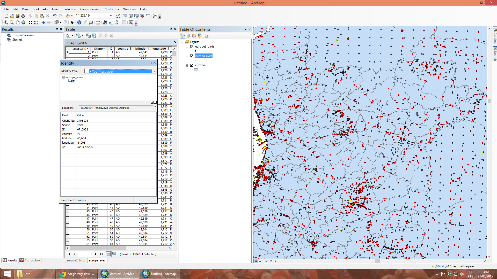
The red points are related with in polygons information, and yellow points are original data.
For some reason it excludes some points. I expected to see a full overlay layers.
I will divide these files into smaller shapes!
Thank you all for trying to help me!
- Mark as New
- Bookmark
- Subscribe
- Mute
- Subscribe to RSS Feed
- Permalink
- Report Inappropriate Content
Yes, because your tables have no related field: that is a field which links the two of them. The only way they can be joined, is by their spatial location, as you are doing.