- Home
- :
- All Communities
- :
- Developers
- :
- File Geodatabase API
- :
- File Geodatabase API Questions
- :
- Re: FileGDBException: The user does not have permi...
- Subscribe to RSS Feed
- Mark Topic as New
- Mark Topic as Read
- Float this Topic for Current User
- Bookmark
- Subscribe
- Mute
- Printer Friendly Page
FileGDBException: The user does not have permission to execute the operation.
- Mark as New
- Bookmark
- Subscribe
- Mute
- Subscribe to RSS Feed
- Permalink
I'm getting this error when trying to execute table.Delete(row), the error is thrown on the first row. There are many tables in this file geodatabase so I've tried with different ones for some tables it works and for others it doesn't. These are all standalone tables, no relationships, editor tracking is not on. File geodatabase is generated from a 10.2.2 geodatabase. This table has a few fields and the only field that stands out is Settings which is defined as nvarchar(max) in geodatabase.
Fields:
ObjectID
Name: text 255
Settings: text 1073741822
ModifiedTime: date
Version: Text 255
SettingsType: Text 255
RowCollection rowCollection = table.Search("*", whereClause, RowInstance.Unique);
foreach (Row row in rowCollection)
{
table.Delete(row);
}
Solved! Go to Solution.
Accepted Solutions
- Mark as New
- Bookmark
- Subscribe
- Mute
- Subscribe to RSS Feed
- Permalink
The API only supports simple features. Extensions are not simple data. so this is consistent. Thank you for verify that this was the issue.
- Mark as New
- Bookmark
- Subscribe
- Mute
- Subscribe to RSS Feed
- Permalink
So the obvious question is: What is different about the tables on which Delete is permitted from those on which it is not? Are there filesystem permission issues? Are you sure there isn't any non-simple aspect to the tables? What does Table::IsEditable report?
- V
- Mark as New
- Bookmark
- Subscribe
- Mute
- Subscribe to RSS Feed
- Permalink
Thanks for quick reply. So to answer your questions, I've been looking at different tables and i don't see anything different, of course i maybe overlooking something or not looking in the right places, BUT IsEditable is returning FALSE, so that is big hint, can you tell me what controls that flag? Code that generates this file geodatabase is a python script, it connects to geodatabase with account that has owner permissions and does this for each table:
source_db = "\\\\" + hostname + "\\Deployment\\Connection.sde"
arcpy.env.workspace = source_db
items = arcpy.ListTables()
for sourceItem in items:
targetItem = string.split(sourceItem, ".")[len(string.split(sourceItem, "."))-1]
target = target_db + "\\" + targetItem
source = source_db + "\\" + sourceItem
arcpy.Copy_management(source, target, "Table")
I can add screenshots from ArcCatalog if you think its helpful
- Mark as New
- Bookmark
- Subscribe
- Mute
- Subscribe to RSS Feed
- Permalink
The API will not allow the edit of table or feature classes involved in Annotation and Dimension feature classes, Relationship Classes, Networks (GN and ND), Topologies, Terrains, Representations, Parcel Fabrics and Edit Tracked tables/feature classes.
Screen shots showing the content of the file geodatabase would be helpful.
Regards,
Lance Shipman
- Mark as New
- Bookmark
- Subscribe
- Mute
- Subscribe to RSS Feed
- Permalink
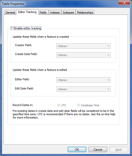
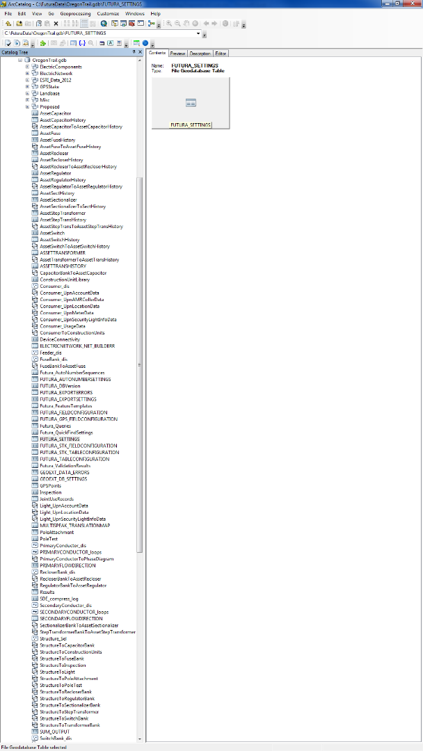
I don't think this table is involved in any of these, I've posted some screenshots.
- Mark as New
- Bookmark
- Subscribe
- Mute
- Subscribe to RSS Feed
- Permalink
It's hard to tell, but it seems those screenshots are from the enterprise geodatabase, not from the FGDB itself.
- V
- Mark as New
- Bookmark
- Subscribe
- Mute
- Subscribe to RSS Feed
- Permalink
Screenshots from fgdb are pretty much the same:


- Mark as New
- Bookmark
- Subscribe
- Mute
- Subscribe to RSS Feed
- Permalink
Can you post screen shots of the contents of the file geodatabase.
- Mark as New
- Bookmark
- Subscribe
- Mute
- Subscribe to RSS Feed
- Permalink
its a lot of stuff
- Mark as New
- Bookmark
- Subscribe
- Mute
- Subscribe to RSS Feed
- Permalink
1) Create a new file geodatabase with ArcGIS Desktop.
2) Copy/Paste the table to the new file geodatabase.
3) Examine the results.