- Home
- :
- All Communities
- :
- Events
- :
- FedGIS Conference
- :
- FedGIS Conference Blog
- :
- Small Businesses Showcase Leading Edge Solutions a...
Small Businesses Showcase Leading Edge Solutions at Esri Fed GIS
- Subscribe to RSS Feed
- Mark as New
- Mark as Read
- Bookmark
- Subscribe
- Printer Friendly Page
- Report Inappropriate Content
Esri’s Federal small business partner specialty (FSBS) community will be on full display at the upcoming Esri Federal GIS Conference in DC on March 20-21, 2018. With over 85 partners in the FSBS, Esri has an amazing community of small business partners who provide a wide range of GIS services and solutions. Here is what to expect at Fed GIS from Esri’s FSBS partners next week.
FSBS PARTNER EXHIBITORS
Fed GIS 2018 will feature an expanded Small Business Pavilion in which the following 14 companies are exhibiting:
- Geodynamics - P1
- Continental Mapping Consultants – P2
- Pro-West & Associates – P3
- GeoCGI – P4
- INCATech LLC – P5
- R&K Solutions, Inc – P6
- PTFS – P7
- Innovate! – P8
- PenBay Solutions – P9
- Critigen – P10
- NorthPoint Geographic Solutions – P11
- New Light Technologies, Inc. – P12
- Bad Elf – P13
- Spatial Front, Inc. – P14
Additionally, the following FSBS partners are exhibiting in other parts of the exhibit hall:
- ArdentMC @ the DHS Booth 535
- Blue Raster - 816
- GISinc - 717
- Voyager Search - 641
Small business partners have been honing their skills and incorporating their tradecraft to create solutions built on Esri’s web based GIS platform, ArcGIS. Using ArcGIS, these partners have adopted the latest technology and implemented their solutions at agencies across the US Federal government. It is truly exciting to see the depth and breadth of these solutions that span every dimension of the Earth, from land, sea, air, indoors to 3D:
On the ground - providing open data and real-time data for disaster emergency response;
Land –planning for our Nation’s forests and other land use applications;
Sea – leveraging Full Motion Video for underwater exploration and analysis;
Air – using drones to conduct surveillance, damage assessments and inspections;
Indoors – using internet of things (IoT) for the management of facilities and assets
3D – modernizing zoning rule visualization for city planning
Here are just some of the highlights of what our small business exhibitors will be showcasing:
ArdentMC demonstrated their public safety and geospatial expertise when they rapidly launched a series of Homeland Infrastructure Foundation Level Data (HIFLD) Open sites in response to the devastating 2017 Hurricane season. These sites supported open data geospatial aggregation – see the sites here: Harvey, Irma and Maria. You can learn more about these implementations from Ardent who will be present in the DHS booth.
Blue Raster will be showing their applications for smart city development and planning:
- The new Economic Development Configurable Application, based on Esri’s newly released ArcGIS Hub, examines all aspects of what makes a city attractive to either a new or re-locating business. These configurable applications take the guess-work out of application development, and allow cities to concentrate on what is important – new business.
- Blue Raster’s work on the The D.C. Zoning Map will also be highlighted. This is a web application provided by the DC Office of Zoning that shows 2016 zoning regulations in an interactive way. An upcoming release will incorporate 3D visualizations, including the ability to search by relevant zoning parameters, examine building shadow covers throughout the day, and view building heights and standards, helping preserve the character of the city while planning future developments.
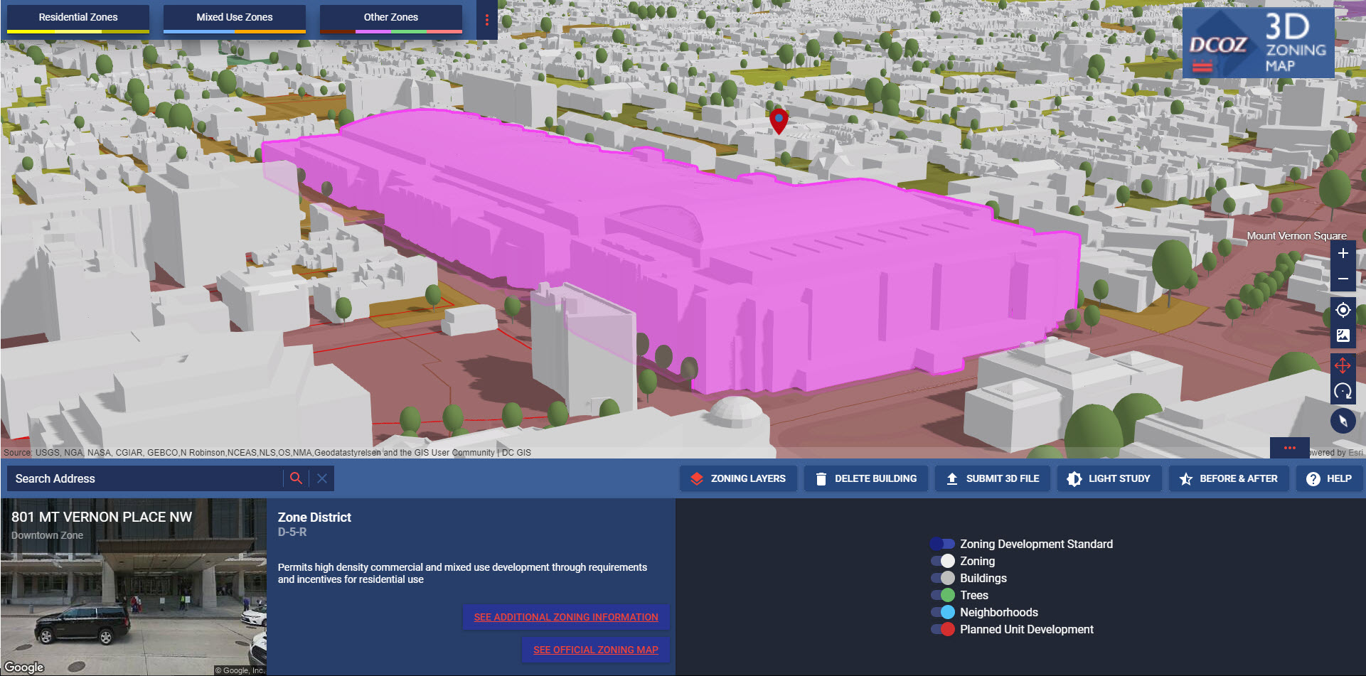
Credit: Blue Raster
Critigen announced that their Story Maps work for the US Forest Service (USFS) is now publicly available here. The public release is for the Salmon-Challis National Forest – the second phase of the solution. In the first phase for the Ashley National Forest, Critigen was awarded the USFS Intermountain Region Regional Forester’s Honor Award for Excellence in Science and Technology. The work is dedicated to rendering relevant geospatial information to inform Forest Planning through standard geospatial desktop tools as well as ArcGIS Online web maps and narrative Story Maps.

Credit: Critigen
GISinc will feature their GeoIoT™ solution for indoor GIS, and how to integrate emerging IoT sensor hardware with your Esri ArcGIS Software. The solution has uses in the areas of asset management, indoor navigation and wayfinding, space management/utilization, water and energy management. Airports, buildings, campuses, healthcare facilities, installations, and public spaces are just some of the places that can utilize this next generation technology.
INCATech will talk about their work on the Dept of State website: https://travelmaps.state.gov/TSGMap. They deployed ArcGIS Online to incorporate dynamic mapping and information about embassies and consulates data to assist those traveling internationally. The website received 11 million views within 36 hours of deployment. INCATech will also show a Story Map of the services they offer and a Crowdsourcing Story Map in which attendees can participate to win a prize.
New Light Technologies will showcase their work on the FEMA Incident Journal, which provides a set of interactive dashboards and maps based on ArcGIS Server and ArcGIS Online. The Incident Journal provides a curated set of authoritative data in real-time to decision makers across the agency’s many divisions and regional offices which need to work together during disaster events. Because of the successful use during the 2016-17 hurricane seasons, the system is being expanded to incorporate other disaster event types including tornadoes, earthquakes, and floods.
NorthPoint Geographic Solutions will be demonstrating a number of web application solutions including
- SmartFor - A new cloud-hosted SaaS GIS Forest Management application which utilizes ArcGIS Online.
- Cleanups In My Community (CIMC) application - for tracking EPA monitored cleanups throughout the U.S.
- Zoning Permitting Application - for the public to apply for land use permits. It also includes administrative and inspector functions and utilizes ArcGIS Online and Collector for ArcGIS.
ANNUAL FSBS AWARDS AND PRESENTATION
We will also recognize our small business partners during the annual FSBS Awards, presented by Jack Dangermond onstage following the plenary on Tuesday March 20. Three partners will receive awards in the categories of Partner of the Year, Innovation Partner, and Collaboration Partner.
Winners will present their solutions during a session on Wednesday, March 21st “Transformational Small Business Implementations” (1:30-2:30pm, Expo Hall Workshop 2).
Session Abstract: Federal government agencies rely on small businesses to quickly adopt and implement the latest trends in GIS technology. These small businesses provide them with new ideas and use cases that allow them to fully exploit the next generation capabilities of GIS. Three small business partners have earned a Federal Small Business Specialty Award in 2018 because of their ability to introduce, implement and extend ArcGIS technology to tackle their customers’ business problems in a transformational way. Hear how these partners improved their customer’s ability to respond to natural disasters, conduct installations inspections, perform environmental damage assessments, as well as better manage their data, space and resources.
Additional workshop sessions presented by FSBS Partners can be found in the attached custom agenda.
BOOTCAMP
We will conclude the week with the annual small business bootcamp on Thursday March 22. This occurs the day after the Federal GIS conference in order for new partners and staff to work more closely with Esri sales and professional services staff, and achieve our common objectives around GIS.
To learn more about the Esri FSBS and upcoming events, go to our website at:
You must be a registered user to add a comment. If you've already registered, sign in. Otherwise, register and sign in.
-
FedGIS 2017
4 -
FedGIS 2018
5 -
FedGIS 2019
1 -
FedGIS 2020
3 -
FedGIS 2021
4 -
FedGIS 2023
4 -
FedGIS 2024
3