FedGIS Conference Blog

cancel
Showing results for 
Show  only  | Search instead for 
Did you mean: 

Other Boards in This Place

Latest Activity

(28 Posts)
ChrisCatania
Esri Community Team

Welcome to Day Two of the FedGIS coverage and story sharing here on the GeoNet Community!  We hope you enjoyed Day One and we're excited to dive into today's events, sessions and workshops.  

ArcGIS Insights Workshop

To start the day, in one of the morning workshops, Linda Beale and Art Haddad, took us through an intro to ArcGIS Insights.  Lots of good questions were asked by attendees including one popular question about being able to do cross-database joins. Many hands were raised when Linda asked how important that was and she appreciated the feedback and was going to consider it for future releases. Contribute to the workshop conversation here

Why Birds Love the Science of Where: National Audubon Society Keynote

Next, it was time to fly in for the morning keynote from David Yarnold, CEO and President of the National Audubon Society, who shared how they transformed their organization into a more collaborative network with GIS and the Science of Where. Here's a collection of highlights and takeaways. 

Jack welcomed us and introduced the keynote with this video sharing the National Audubon Society story.

In the past, the NAS didn't have a clear vision of the impact and influence of their work. So using the global map image below, David began to help his team transform how the NAS saw itself and understand the global impact of their work.

David, a former leader at the San Jose Mercury news, told a story about how when an oil spill happened in San Jose they used an old base map and just wrote "oil spill on it" in an area that wasn't correct or geographically accurate. He said this was a key moment that inspired and reminded him of why his team needed to leverage the Science of Where in their work. 


David shared that "If you take care of birds, you can take care of the worlds biggest problems" and using GIS and maps empowered his team to communicate this powerful message both to their own organization and the world. "GIS takes ideas out of your head and puts them on the table. When we can all look at it together we can iterate shared visions of the future."


David shared that as they begun to create "a conversation network," their organizational change "aha moment" was driven by GIS in three ways:

  • Sophisticated conversation planning
  • Collaborate workspace 
  • Authoritative, shared data

David shares the five year vision for the National Audubon Society:

Sharing insight from his journalism and media background, David highlighted the importance of using compelling GIS data to engage the media to get the word out about important issues and tell more compelling stories in the press. 

Demonstrating the power of GIS and maps to create real change David shared how this story map about the Piper Polver helped turn a map and data into policy. 

It was a great keynote and we'd love to hear what you thought. Share your comments below!

National Mapping and Imagery Workshop

After the keynote, I swung by the "National Mapping and Imagery: See the Earth, Find the Patterns, and Share the Knowledge" workshop as Mark Romero and Kurt Schwoppe from Esri they explained and demoed how drones, imagery and photogrammetric production in ArcGIS online and Drone2Map is being use to update historical images and enhance current data sets. The use cases highlighted the importance and challenges of collaboration, and how the combination of tech helped local and federal agencies recover from Hurricane Matthew and cast a vision for improving roadways and infrastructure projects. We invite you to continue the workshop conversation here.

Spatial Data Mining I: Essentials of Cluster Analysis workshop

I enjoyed checking out the Spatial Data Mining I: Essentials of Cluster Analysisworkshop hosted by Lauren Bennett and Flora Vale. Using examples of car crime in local communities, they shared helpful details, insights and live demos about the value of doing thoughtful cluster analysis and highlighted how they incorporated the Getis-Ord Gi* Statistic into the hot spot tool set. We invite you to continue the workshop conversation here.


ArcGIS Online Content - Building a Living Atlas of the World workshop

The world (and its digital twin) is always changing and during the Building a Living Atlas of the World session, Sean Breyer and Deane Kensok from the Esri team, showed how the Living Atlas platform gives users a broad set of tools to use.  They shared the depth of the Living Atlas content portfolio (image below) and how big of a role the tools are playing in helping users keeping their imagery data updated and how precise the new imagery tools is. For example, as seen in the image below, the Living Atlas images are can be so precise that you can see the shadows clear enough to tell that baseball players are left and right handed. And this helps users create better maps and data sets. Check out the livingatlas.arcgis.com to get started. We invite you to continue the workshop conversation here:FedGIS Discussion: ArcGIS Online Content - Building a Living Atlas of the World  

And that's a wrap! Thanks for following along on the updates during the FedGIS 2017 Conference. We had a great time connecting and collaborating with you. Let's continue the conversation! Check out other discussions about the events and workshops, start new discussion and ask questions in the FedGIS Conference‌ space. 

more
0 1 1,079
ChrisCatania
Esri Community Team

Editor's note: We're live blogging the Monday morning plenary on this post. For more discussions and updates this week visit the FedGIS Conference‌ space here in the GeoNet Community. 

9:00amEST

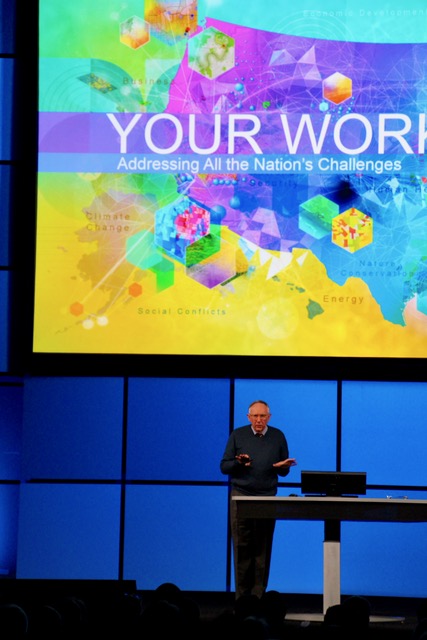
FedGIS 2017 is underway! The plenary kicks off as Jack welcomes attendees and continues an Esri conference tradition inviting us to turn around and say "hello" to each other. I had the pleasure of talking with Rolando from the Department of Defense. He's excited to learn more about clean data and GIS. 


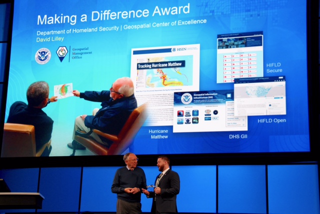
Jack jumps in and recognizes the Winners of the Global Content Challenge, and then David Lilley of the Department of Homeland Security is awarded the "Making a Difference award. David thanks Jack and says this recognition and important work is because of "the power of partnerships built with Esri. 

Jack shares his vision of the future of GIS and it's impact on the world: "If we're going to have a positive future. It's going to take us working together to make it work." 

Jack shares the Science of Where. "What is it? It's the "Geography and Technology of GIS coming together." 


"Humans have never been more capable, now is the time to apply the Science of Where. We need to scale it out.  realize what is possible and collaborate among all levels of our organizations." 

9:30am 

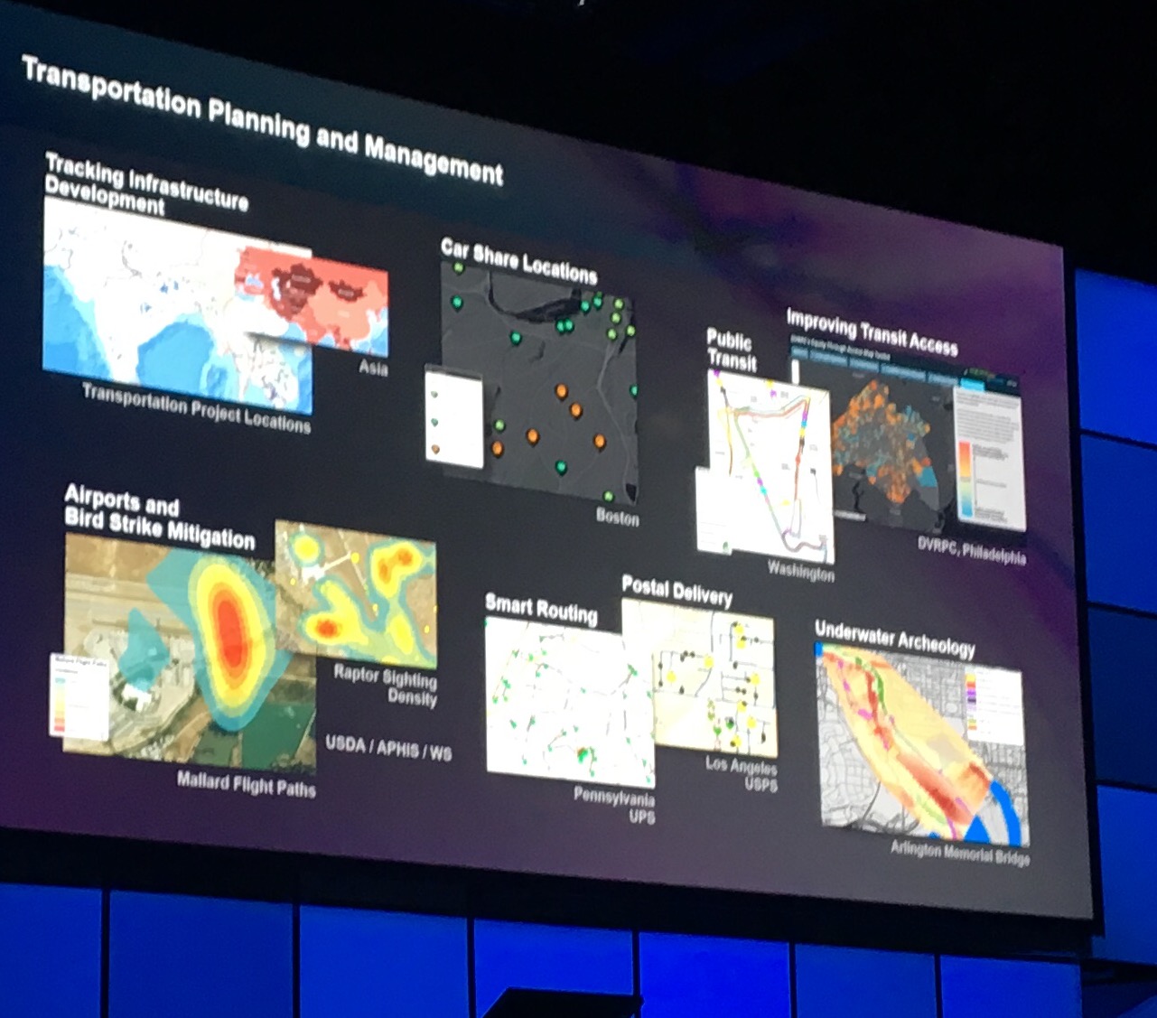
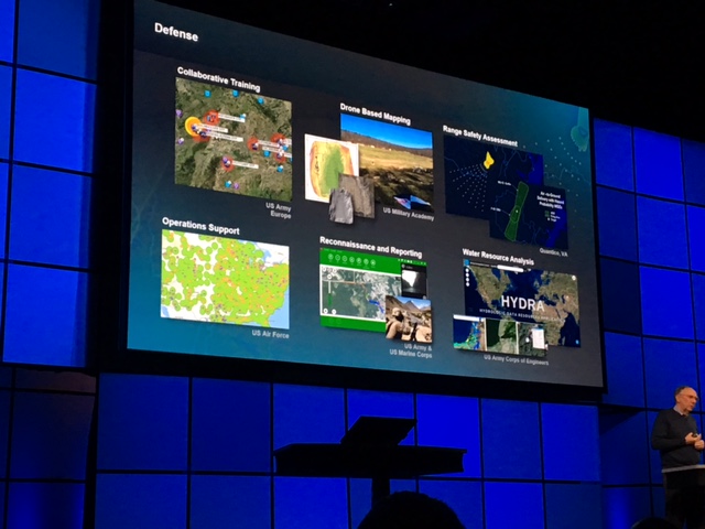
Jack highlights the impact and power of GIS in government agency and projects. 

 9:45am 

Jack dives into sharing how Big Data, Imagery and Real-time are key elements to Esri platform and they are impacting GIS and together they changing how we understand our world. 

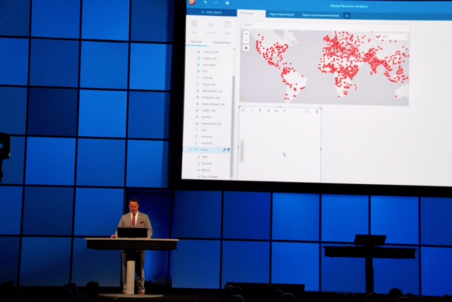
Jack shares that "Smart means real-time. This is so exciting!" He then welcomes David Attaway who demonstrates the power of Insights showing it as a powerful platform and tool to fight global terrorism and its sociogeographic impact. 

10:00am

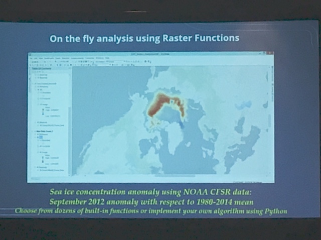
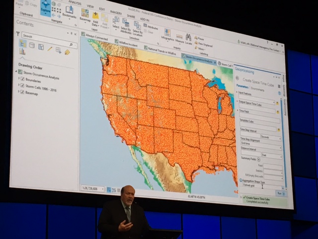
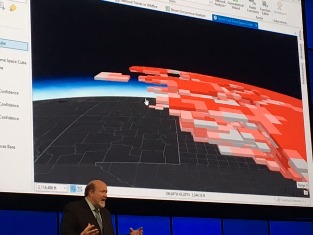
Tim Clark shares how ArcGIS Pro is improving workflows through wildfires. He takes us through a real-time use case and shows us how to use the 3D imagery and space time cube.  "You can maximize your data and apply it to the meaning of your symbology. ArcGIS Pro is a connected environment and this integration can make your workflows easier."  

10:30am

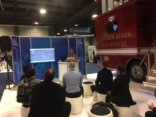
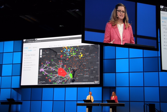
A portal to portal cross-agency use case shows how the Fusion Center in Virginia is collaborating with partners to better understand and address issues caused by heroine overdoses in their local counties. 

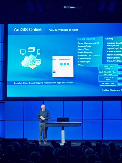
Jack shares the new stats on ArcGIS online:

  • 3.8 Million users 
  • 1 Billion day map views 
  • 7.9 million items
  • 18.8 million open data downloads 

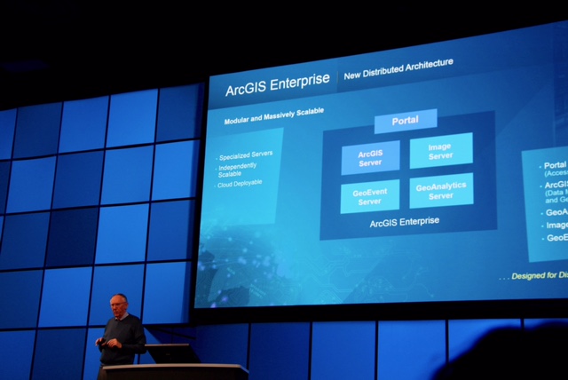
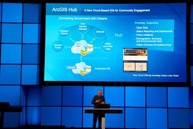
Jack takes us through the ArcGIS Enterprise and its new distributed architecture, and then gives us a tour of the ArcGIS Hub that's a new cloud-based GIS for community engagement. 

10:45amEST

Heading into the break Jack thanks the audience. "Geography has never been so important. It's enabling the Science of Where and creating a platform for creating a better future.  You've made it come alive. You're building the maps that run our country. It's a great privilege to serve and work with you." 

We're taking a short break on the plenary and will be back shortly.  What did you think so far? Share your thoughts and feedback in the comments! 

11:08am

And we're back! A video about the "Science of Where" welcomes us back.

Then Tyson Quink takes us through what's new in ArcGIS online: 

  • Vector basemaps 
  • Joined features tool  
  • Publishing WSFS servers in web maps 
  • New and improved Smart mapping and 3D
  • Analysis tools, vector tiles and more. 
  • Publish to 3D mapping and Droan2map

11:30am

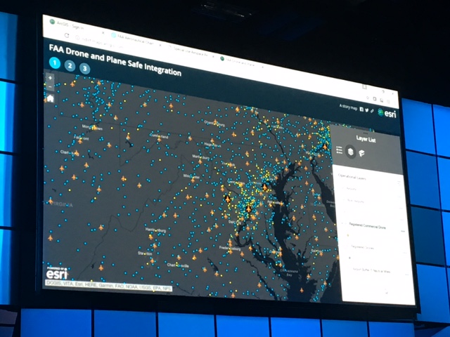
Federal Aviation Administration team takes us through how they use ArcGIS to make sure planes stay out off restricted airspace when landing in Washington DC and flying for passengers remains safe and uneventful so you can send that happily send that "just landed" text to your family." 
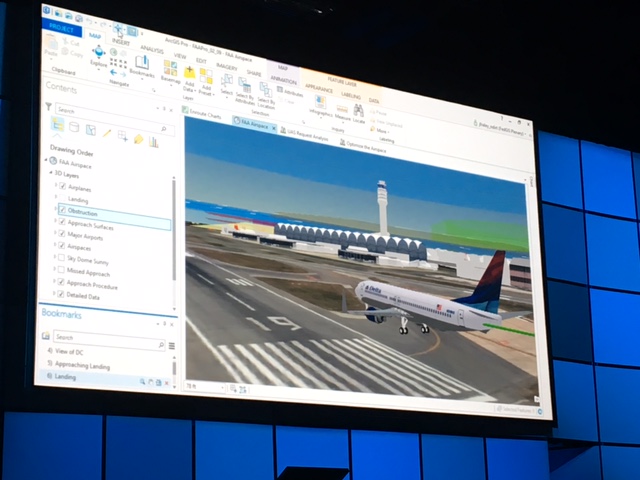
Did you know...?

  • 690,000 drones are in operation since they first become legal to fly in recent years. 
  • Drones can freely fly below 400 feet but the FAA still has to figure out how we balance legal drone flight paths with maintaining safe airspace that is always dynamic and changing. (yes, they use ArcGIS to do it)

11:50am

 The Chesapeake Conservatory team shows how they are using ArcGIS Pro to better understand and solve watershed issues. "In the past this type of data processing might take a week, with ArcGIS Pro we are able process 3.8 billion pixels of NAIP imagery in high resolution in 5 minutes."

 12:02pm

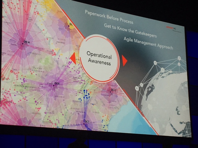
The Ardent MC team shares how they used the Operations Dashboard to bring teams together to make decisions, synchronize data and promote operational awareness.  

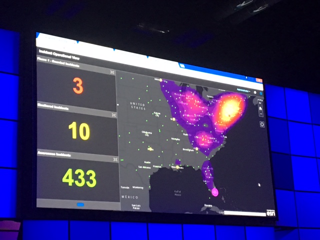
They also shared 3 tips to create Operational Awareness with GIS:

1. Paperwork before process. Do this first before begin your projects. 

2. Get to know the gatekeepers. Build relationships and educate those who are the influential and on the front lines.

3. Agile Management approach. Agile isn't just for product development use it to manage your teams and change how you work. 


12:15pmEST

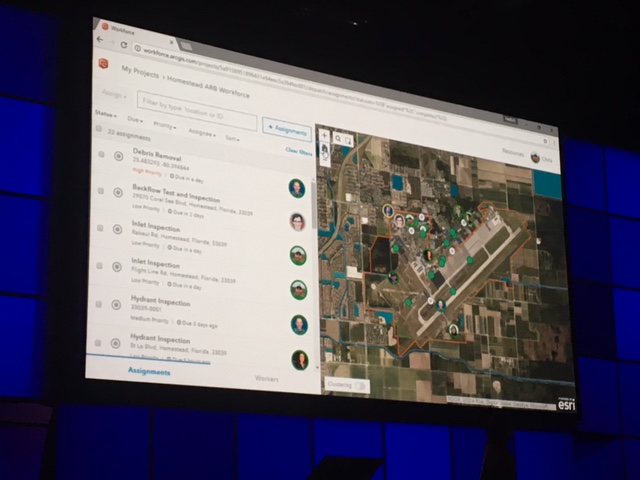
We have apps! Chris from the Esri team takes us through how you can take GIS into the field via the helpful workforce friendly and mobile Field Apps.

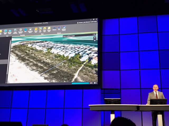
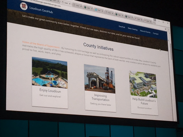
The Loudoun county team takes us through their new GeoHub and share how they're using it to improve the lives of the local families and businesses. 


And that's a wrap! We hope you enjoyed the plenary presentations. What did you think of the talks and demos? Share your thoughts and comments below. 

Thanks for following along during this live blog. As the conference continues, be sure to join the discussions and daily update conversations in the FedGIS Conference‌ space.  

more
2 2 1,518
ChrisCatania
Esri Community Team

Hi everyone - We're here in Washington, D.C. and excited to get started at the FedGIS Conference! Attendees are making their way in and grabbing their Esri swag bags and heading into the plenary. We'll be live blogging the plenary here on a separate blog post. You can follow that live blog for Monday morning plenary.

Then over the next two days, we'll be starting separate session conversations and sharing updates as the event unfolds. Remember to follow the FedGIS Conference‌ space to get the updates and join the conversations. 

Enjoy your time and thanks for following along. We look forward to your contributions!

After the plenary, it was time to grab some lunch and listen in on a meaningful You Got The Job...Now What? panel discussion hosted by the Esri Young Professional team. The guest panel, which also included Esri owner Jack Dangermond, shared their collective career wisdom and insightful personal stories about how to build and cultivate productive relationships to further your career. 

Feeling inspired and ready for the afternoon adventure, I headed downstairs to explore and see what was buzzing on the Expo floor of FedGIS. 

The sires went off as I soaked up knowledge about how law enforcement in Philadelphia is using ArcGIS Pro to map crimes, fires and gang violence to help local investigators discover patterns and make better decisions when fighting crimes. Good to know the good guys in Philly are using the Science of Where and ArcGIS Pro to make their neighborhoods safer. 

After the informative fire drill, I headed upstairs to get into data Sciences mode during the Analyzing Multidimensional Scientific Data in ArcGIS"  workshop. I learned a lot about what "on-the-fly rasta analysis using Raster Functions" looks like when you're trying to understand ice concentration anomalies using NOAA CTSR data. Cool stuff!

I then slipped on the VR goggles and jumped into an immersive version of downtown Savanah, Georgia created by the team at SCAD who made this virtual world in 5 weeks using city engine. The project is a first step in figuring out how virtual reality, augmented reality and 3D printing can help improve data sets and create a more accurate digital version of the world around us. It was a pleasure talking with the SCAD team about their project because our chat led to a fantastic discussion that covered GIS and emerging tech, digital parenting and how the GeoNet Community has helped other SCAD student solve geospatial problems. 

Day One ended with a great workshop about how citizen apps are growing in use and helping to crowdsource and fund the development of citizen science. 

We hope you enjoyed following along as we cruised through Day One of FedGIS 2017! What were your highlights and favorite moments? What did you learn today? Thanks for sharing! 

Stay tuned for more tomorrow and check out other discussions in the FedGIS Conference space.  

more
0 1 976
ChrisCatania
Esri Community Team

We're excited to announce that next week we'll be onsite at the FedGIS 2017 conference in Washington, DC.  During the week we'll be live blogging, sharing updates and starting collaborative session conversations here in the FedGIS Conference space and other groups throughout the GeoNet community.  Whether you're attending the event or following along virtually, we invite you to join the FedGIS conversation on GeoNet.

What topics, sessions and conference events are you most excited about? 

Thanks for joining and we look forward to seeing you and your contributions! 

more
3 1 1,414
29 Subscribers