- Home
- :
- All Communities
- :
- Services
- :
- Esri Training
- :
- Esri Training Questions
- :
- Re: May 15, 2018: Cartography. MOOC Ask Me Anythin...
- Subscribe to RSS Feed
- Mark Topic as New
- Mark Topic as Read
- Float this Topic for Current User
- Bookmark
- Subscribe
- Mute
- Printer Friendly Page
May 15, 2018: Cartography. MOOC Ask Me Anything (AMA)
- Mark as New
- Bookmark
- Subscribe
- Mute
- Subscribe to RSS Feed
- Permalink
- Report Inappropriate Content
Live Today! AMA Event on GeoNet
Tuesday, May 15, 9:30 a.m. - 10:30 a.m. (PDT)
Join our Cartography. MOOC guests here on the GeoNet Community for a LIVE AMA (Ask Me Anything) event. The AMA will take place in this discussion thread on Tuesday, May 15, 2018, from 9:30 a.m. - 10:30 a.m. (PDT).
*Click HERE to convert exact time for different countries.
This is an opportunity to ask our guests questions about the Cartography. MOOC course, about cartography in general, great maps, best practices or anything else that comes to mind.
AMA Guests
How does the AMA work? During the AMA, you can post your questions by clicking the "Add Reply" button below and our guests will reply to your questions in comments. You are welcome to post questions ahead of the AMA and they will answer them during the AMA.Please note: You must be logged in to post questions and see responses. See instructions on How to Log into GeoNet for the AMA. AMA Tips and GeoNet Community Guidelines
- When asking questions and comments during the AMA, remember to follow the GeoNet Community Guiding Principles: Be Helpful, Be Human, Be Smart.
- This discussion page will not auto-refresh, so please remember to refresh this page to see new questions, comments and replies.
Please note: The AMA will be live when you see a picture of our guests below. We are live!
 |  |
9:30 a.m. - And we're live! Go ahead and ask your questions!
9:45 a.m. - If you are just joining us, feel free to ask any question.
10:00 a.m. - We're halfway through, Great questions! Keep them coming!
10:15 a.m. - If you are just joining us, feel free to ask any question.
10:25 a.m. - Five minutes to go! Got any fun questions for our Guests?
10:30 a.m. - And that's a wrap! The live AMA has ended with our wonderful Cartography. MOOC Guests.
Thank you for your questions and participation.
The thread has shifted to a time-stamp view. To view the threads in their entirety, you can select the Actions above the right corner of the discussion thread and select View PDF.
- Mark as New
- Bookmark
- Subscribe
- Mute
- Subscribe to RSS Feed
- Permalink
- Report Inappropriate Content
... and no, I'm not British.
- Mark as New
- Bookmark
- Subscribe
- Mute
- Subscribe to RSS Feed
- Permalink
- Report Inappropriate Content
All good. I have all three. I'd say the latter is more practically focused. It also bridges pure cartography with design in a more general sense. It has far more examples than the others. It's visually enticing and less, ahem, academic in layout,structure and tone. It also has somewhere in the order of 100 contributors which means it's a collective 'voice' for what cartography is in 2018. There's a reason it has a period (full stop) at the end of the title...it's really the only book you need going forward. A desk companion, a sage, a reference, a compendium of sound advice and encouragement to think about the importance of thinking in cartographic design.
All that said, it's really up for others to review and determine how they see my contribution. And that's something I am scared stiff of!!!
- Mark as New
- Bookmark
- Subscribe
- Mute
- Subscribe to RSS Feed
- Permalink
- Report Inappropriate Content
Would you please enlighten those of us who have no idea what those are? Books?
Thank you!
- Mark as New
- Bookmark
- Subscribe
- Mute
- Subscribe to RSS Feed
- Permalink
- Report Inappropriate Content
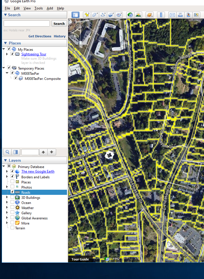
I have encountered some strange "zig zag" lines while working with an .mxd file and downloading some tax parcel property lines onto the map. I am creating a map of a small area of about 5 towns and have added a layer which is actually a polygon on top of the raster image of the area I am studying. The taxpar "lines" don't look like lines at all ,but rather appear like a sawblade edge. They also do get really fuzzy and pixelated when I zoom in.
Please help as this is a very important project for us.
thanks,
Larry
- Mark as New
- Bookmark
- Subscribe
- Mute
- Subscribe to RSS Feed
- Permalink
- Report Inappropriate Content
Hi Larry. When line features are really packed with curves the nodes and curves can really stack up at some scales. Try generalizing your line. Also, play with the line symbol. You can change the bends to look rounded, which is a super trick.
- Mark as New
- Bookmark
- Subscribe
- Mute
- Subscribe to RSS Feed
- Permalink
- Report Inappropriate Content
John,
Thanks much for your help. I have tried to change the symbol and that has not worked.
I have attached a "snip" of what I am encountering.
the lines appear to be vectors, but perhaps you are on to something by referring to them as curves.
Also, need to address the blurring or pixelating when I zoom in.
thanks,
LT

- Mark as New
- Bookmark
- Subscribe
- Mute
- Subscribe to RSS Feed
- Permalink
- Report Inappropriate Content
I know in ArcGIS Desktop if you had a layer with transparency above other layers, it would rasterize layers below (even vector layers). Don't know if Pro does this, but may be something to look at.
Loren
- Mark as New
- Bookmark
- Subscribe
- Mute
- Subscribe to RSS Feed
- Permalink
- Report Inappropriate Content
Can you provide more information about how you're bringing this data into Google Earth? As a service? Exported as KML?
- Mark as New
- Bookmark
- Subscribe
- Mute
- Subscribe to RSS Feed
- Permalink
- Report Inappropriate Content
Your lines are vector or are they part of the raster? It sounds like you may be looking at raster data.
- Mark as New
- Bookmark
- Subscribe
- Mute
- Subscribe to RSS Feed
- Permalink
- Report Inappropriate Content
Craig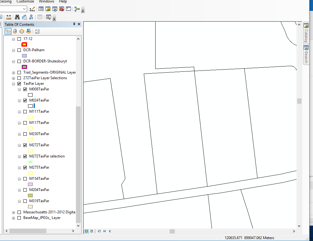
 ,
,
Thanks much for your help. I have tried to change the symbol and that has not worked.
I have attached a "snip" of what I am encountering.
the lines appear to be vectors, but perhaps you are on to something by referring to them as curves.
Also, need to address the blurring or pixelating when I zoom in.
thanks,
LT