- Home
- :
- All Communities
- :
- Services
- :
- Esri Training
- :
- Esri Training Questions
- :
- Re: Mar. 2, 2018 - Earth Imagery at Work AMA (Ask ...
- Subscribe to RSS Feed
- Mark Topic as New
- Mark Topic as Read
- Float this Topic for Current User
- Bookmark
- Subscribe
- Mute
- Printer Friendly Page
Mar. 2, 2018 - Earth Imagery at Work AMA (Ask Me Anything)
- Mark as New
- Bookmark
- Subscribe
- Mute
- Subscribe to RSS Feed
- Permalink
- Report Inappropriate Content
Live AMA Event on GeoNet: Friday, Mar. 2, 10:30 a.m. - 11:30 a.m. (PST)
We invite you to join Earth Imagery at Work MOOC instructors Kevin Butler and Emily Windahl here on the GeoNet Community for a LIVE AMA (Ask Me Anything) event. The AMA will take place in this discussion thread on Friday March 2, 2018 from 10:30 a.m. - 11:30 a.m. (PST).
*Click HERE to convert exact time for different countries.
This is an opportunity to ask Kevin and Emily questions about the course, about earth imagery data, Esri software, GIS or anything else that comes to mind.
How does the AMA work?
During the AMA, you can post your questions by clicking  the "Add Reply" button below and Kevin and Emily will reply to your questions in comments. You are welcome to post questions ahead of the AMA and they will answer them during the AMA.

Please note: You must be logged in to post questions and see responses. Please see instructions on How to Log into GeoNet for the AMA.
We are live with Kevin Butler and Emily Windahl!
 |  Thanks for joining us! |
AMA Tips and GeoNet Community Guidelines
- When asking questions and comments during the AMA, remember to follow the GeoNet Community Guiding Principles: Be Helpful, Be Human, Be Smart.
- This discussion page will not auto-refresh, so please remember to refresh this page to see new questions, comments and replies.
10:30 am - And we're live! Go ahead and ask your questions!
11:00 am - We're halfway through, Great questions! Keep them coming!
11:25 am - Five minutes to go! Got any fun questions for Kevin or Emily?
11:30 am - And that's a wrap! The live AMA has ended with Kevin and Emily. They will continue to answer questions as schedules allow.
Thanks for joining us and asking great questions!
- Mark as New
- Bookmark
- Subscribe
- Mute
- Subscribe to RSS Feed
- Permalink
- Report Inappropriate Content
Hello, and thank you for doing this AMA. I have recently been curious about something and didn't exactly know who to ask it. This seems to be the perfect opportunity. So I hope that you can shed some light to it. Thanks in advance! Here it goes:
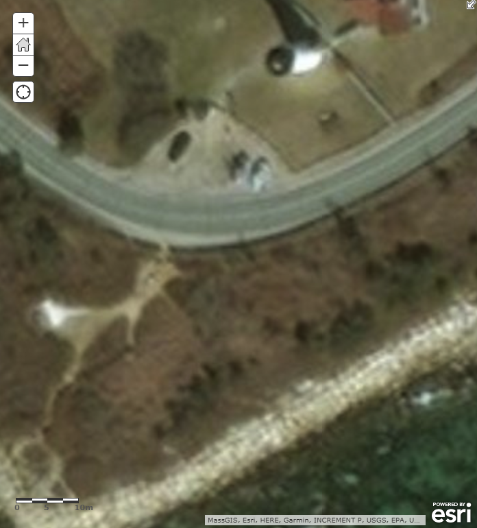
Esri World Imagery Basemap (here) uses a combination of different resolution (0.3 to 15m) imagery files. The underlying Esri High Resolution Imagery (here) claims to have 0.3m resolution imagery in the continental United States. And I believe this used to be the case because I remember using it to verify 1m resolution imagery from another source. However, recently the image quality seems to have degraded substantially (please see image below). The white object at the top of the image is a light house and three rectangular objects in front of it are cars. Clearly the resolution is not 0.3m and zooming in does not refresh the map to a higher resolution. Would you have any comments on why the higher resolution images are not available any more? I am scared to ask, but are they planned to be a part of a paid, premium subscription? Hopefully not!
Thank you for your time
Zafer

- Mark as New
- Bookmark
- Subscribe
- Mute
- Subscribe to RSS Feed
- Permalink
- Report Inappropriate Content
If I understand what you are asking correctly the imagery that was previously available you're speaking of has now been renamed and can be found as "World Imagery Clarity" here it has pretty decent resolution but is quite aged. Similar to what you are saying though I have noticed a major decline in resolution through ESRI's new provider of world imagery in the area I primarily use it (South Eastern Minnesota) and also in other metropolitan areas. 
I don't think anyone would agree that the "new" imagery is more clear than the old.
- Mark as New
- Bookmark
- Subscribe
- Mute
- Subscribe to RSS Feed
- Permalink
- Report Inappropriate Content
Hello Zafer,
Have a look at this blog post from January. It helps explain the big change that happened then. The good news is that the older imagery is still available if that suits you better.
Adena
- Mark as New
- Bookmark
- Subscribe
- Mute
- Subscribe to RSS Feed
- Permalink
- Report Inappropriate Content
Thank you, I have seen that blog. "The underlying Esri High Resolution Imagery (here) claims to have 0.3m resolution imagery in the continental United States." It does not. Neither new nor old, it simply does not exist anymore...
- Mark as New
- Bookmark
- Subscribe
- Mute
- Subscribe to RSS Feed
- Permalink
- Report Inappropriate Content
RWaterman-esristaff, can you help Zafer with this question?
- Mark as New
- Bookmark
- Subscribe
- Mute
- Subscribe to RSS Feed
- Permalink
- Report Inappropriate Content
We do have 0.3m imagery coverage in the Continental US (some comes from DigitalGlobe and some comes from our Community Maps Program). The 0.3m Bing Aerial imagery that covered the entire CONUS (which I think is what you are looking for) is no longer available in the World Imagery basemap due to it's age. However, it is still available through the World Imagery (Clarity) basemap.
As an example of our Community Maps Imagery, we have recently published 20 counties in New York with 0.3m or better aerial imagery. Check out What’s New in World Imagery Basemap (February 2018) for some of the latest updates.
- Mark as New
- Bookmark
- Subscribe
- Mute
- Subscribe to RSS Feed
- Permalink
- Report Inappropriate Content
However, it is still available through the World Imagery (Clarity) basemap.
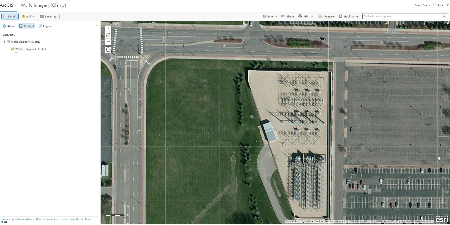
No, it is not. Below is the same imagery from World Imagery (Clarity) basemap. And I am not the only one who is complaining about the reduced quality of the imagery (see the comments in the blog posts mentioned above). Can somebody please refer us to a basemap that is verified to have the same (or better) resolution with the old ESRI High Resolution Imagery?
Thanks

.png)
- Mark as New
- Bookmark
- Subscribe
- Mute
- Subscribe to RSS Feed
- Permalink
- Report Inappropriate Content
No, it is not. Below is the same imagery from World Imagery (Clarity) basemap.
World Imagery (Clarity) does contain the 0.3m imagery that was previously in World Imagery. In the original question posted there was a screenshot from World Imagery and the same location again here from Clarity. There is a distinct difference between the two samples, where the second example, from Clarity, is sharper/more detailed. Please let me know if something else was meant by "same imagery".
Can somebody please refer us to a basemap that is verified to have the same (or better) resolution with the old ESRI High Resolution Imagery?
World Imagery (Clarity) basemap contains the old high resolution (Bing) aerial imagery for the CONUS that is no longer available in World Imagery.
- Mark as New
- Bookmark
- Subscribe
- Mute
- Subscribe to RSS Feed
- Permalink
- Report Inappropriate Content
Please pay attention to the scale bar at the corner of the images. I am not talking about whether it is better or not, what I am saying is 0.3 m resolution imagery product does not exist anymore. Thank you for trying to help, but I am yet to see an example that shows 0.3m resolution image rather than a generic link to imagery services.