- Home
- :
- All Communities
- :
- Services
- :
- Esri Technical Support
- :
- Esri Technical Support Blog
- :
- What Do I Put in My Metadata?
What Do I Put in My Metadata?
- Subscribe to RSS Feed
- Mark as New
- Mark as Read
- Bookmark
- Subscribe
- Printer Friendly Page
In ArcGIS 10, metadata workflows have changed quite a bit compared to previous versions. For more information regarding metadata in ArcGIS 10, see "A New Approach for Metadata with ArcGIS 10 Part 1, Part 2 and Part 3."
One of the most common questions we get in support is: "How do I know what to put in the metadata?" The answer depends on a number of things, most notably, what type of metadata is being created. The type of metadata created depends on what metadata style is specified in the ArcCatalog Options dialog. See the help here for more information on how to set the metadata style.
A simple way to determine what you need to enter when you're authoring metadata is to look at what's displayed in the context help at the bottom of the ArcCatalog window. For instance, as shown below, when the cursor is placed under Description in the Item Description section of metadata created using the North American Profile of ISO 19115 2003, the context help will produce a message that indicates what type of information is expected.
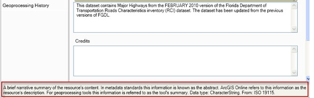
The above message outlined in red indicates that information included in the Description of the metadata should be similar to information included in an abstract.
In some cases, the Context Tip may not offer enough guidance. That's when it's time to refer to published content standards. These content standards are a wealth of information regarding what can be included in metadata. All content standards, including FGDC, North American Profile of ISO and INSPIRE are available on the Web.
For more information, please review the links below.
The FGDC Content Standard for Digital Geospatial Metadata
The North American Profile of ISO 19115:2003
The documentation for the INSPIRE Metadata Regulation
You must be a registered user to add a comment. If you've already registered, sign in. Otherwise, register and sign in.
-
Announcements
70 -
ArcGIS Desktop
87 -
ArcGIS Enterprise
43 -
ArcGIS Mobile
7 -
ArcGIS Online
21 -
ArcGIS Pro
14 -
ArcPad
4 -
ArcSDE
16 -
CityEngine
9 -
Geodatabase
25 -
High Priority
9 -
Location Analytics
4 -
People
3 -
Raster
17 -
SDK
29 -
Support
3 -
Support.Esri.com
60
- « Previous
- Next »