Esri Technical Support Blog - Page 3

cancel
Showing results for 
Show  only  | Search instead for 
Did you mean: 

Latest Activity

(383 Posts)
GregoryLehner
Esri Contributor

As you may or may not be aware, a recent security vulnerability was unveiled for servers using the OpenSSL cryptographic library that affects many different products and software worldwide. This vulnerability has been codenamed 'The Heartbleed Bug', and potentially allows attackers to read the memory of a protected server or client and retrieve encrypted personal information from that server/client.

As a result, Esri staff have been performing maintenance to validate, secure, and patch Esri servers and infrastructure to close this vulnerability and ensure Esri customers are protected.

Please read the following KB Article for further information regarding the Heartbleed bug and whether any customer action is required for your Esri software.


Gregory L. - Online Support Resources

more
0 0 342
MelissaJarman
Esri Contributor

Query layers were first introduced at the 10.0 release primarily to allow ArcMap to integrate data from databases that do not contain the system geodatabase repository tables. Think of query layers as a method for accessing database objects that are not geodatabase-aware, without having to go through the process of registering the objects with ArcSDE or the geodatabase.

When first released, the only way to create a query layer was in ArcMap using the Add Query Layer tool, which also required a special connection file (.qcf). This file was required for ArcGIS to connect to databases that did not have a geodatabase component. Native access to both spatial and non-spatial database objects through the ArcGIS client application allowed for the ability to integrate a wider spectrum of data into GIS projects, and provided the ability for modification to include a specific subset of data – similar to a definition query and/or a database view.

With the ArcGIS 10.1 release, new functionality was added to make database connections native in ArcGIS, which eliminated the need to create the query connection file (.qcf) when building query layers. Query layers evolved from something that could only be manually built to a behavior that automatically occurs when accessing database objects that are not geodatabase-aware through a database connection file (.sde) in ArcGIS. In other words, query layers are generated dynamically by adding non-geodatabase objects to ArcMap via drag and drop from the Catalog window.What is a query layer?

Are query layers read-only?


Query layers are read only in ArcMap. At the 10.1 release, ArcGIS Spatial Data Server (SDS) services were introduced, which allowed the publishing of database data in an editable feature service. At 10.2, ArcGIS for Server feature access enabled map services were enhanced to allow data to be published from database connections that didn’t contain the geodatabase system tables. This opened up the ability to edit query layers via an ArcGIS for Server feature service and eliminated the need for the ArcGIS Spatial Data Server (SDS).Ability to edit query layers:
VersionEditable?
10.0No
10.1Yes – via SDS service
10.2Yes – via feature access enabled map service

To edit the data at 10.1, create a map that contains your database data, and publish that data to the ArcGIS Spatial Data Server service.

NOTE: To publish editable feature services via SDS, ensure the layer is not contained within a geodatabase.

Beginning with ArcGIS 10.2, you should use ArcGIS for Server feature services to publish data from supported database management systems. This allows you to edit query layers via the feature access enabled map services, and takes the place of ArcGIS Spatial Data Server feature services (which have been deprecated). These workflows are intended for databases that do not have the geodatabase system repository tables populated; I like to call these NON-geodatabases.

NOTE: When authoring feature services using enterprise or workgroup geodatabases, all data must be registered with the geodatabase. This means that if you have query layers or spatial tables contained within a geodatabase that are not registed with the geodatabase, you will experience errors in analyzing when preparing to publish. Your options are:
  • Register the spatial tables or query layers within the existing geodatabase, creating feature classes
  • Publish the feature service from a NON-geodatabase (a database that is not enabled with the system repository tables)
  • Publish query layers from a map service and overlay these with feature service layers in a web map

Database views are not supported for publishing via feature services within a geodatabase because they cannot be registered with the geodatabase.

How to create a query layer


A query layer can be created manually in ArcMap by building a query against objects that exist within a geodatabase or a database that does not contain the geodatabase system repository tables. You should use this method to create a query layer if you need to define a subset of data. For example, when working with a layer that contains a large number of features, you should use the Add Query Layer tool and include a 'where' clause that restricts the number of features that will be included in the query layer.
  • Build a Query Layer manually using the ‘New Query Layer’ dialog in ArcMap: File > Add Data > Add Query Layer

A query layer is created when the layer/table that is not registered with the geodatabase is added to ArcMap via these additional methods:
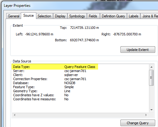
  • Starting at 10.1 - Drag and drop a database layer into ArcMap from ArcCatalog or the Catalog window in ArcMap –The ArcMap Layer properties will display a Data Type of ‘Query Feature Class’ within the source tab
  • Using the Add Data button within ArcMap to add data from a database
Creating a query layer

Display behavior of database data in ArcGIS

ArcGIS for Desktop reads the layers in a database that contain feature geometry and displays them within ArcCatalog. How these appear in the Catalog tree changed starting at the 10.1 release. When data is viewed in ArcCatalog or the Catalog window in ArcMap, a new icon is displayed. MJarman02-Icon1.pngThis icon indicates that the object is a non-geodatabase aware/registered table with a spatial component/column.
  • Dragging a database layer with this icon into ArcMap would create a query layer where the feature geometry is discovered and rendered.
  • Double-clicking this object within ArcCatalog will discover and change the icon to a feature class icon for the specific geometry type that is stored in the geometry column.
MJarman03-Icon2.jpg
  • Within ArcMap the layer will display similarly to a feature class, but checking the layer properties source within ArcMap reveals the Data Type of Query Feature Class.
MJarman01-Layerproperties.pngViewing database data in ArcGIS

SUMMARY


Important things to note about query layers:
- Query layers only persist within the map document that they were created in
- Query layers do not require a geodatabase
- Query layers are read-only in ArcMap when added directly from a database connection
- Currently, query layers are only editable when accessed via certain types of services and datasources:
  • 10.1 – Spatial Data Server feature access enabled services can edit query layers
    • This functionality only existed for one product release as it was incorporated into the feature access enabled map service at the 10.2 release
  • 10.2 – Query layers can be edited as part of a feature enabled map service published from databases (not enabled with the geodatabase system repository tables)

- .qcf files are query connection files that were generated for the 10.0 release to allow the connection to a non-geodatabase-aware relational database to build a query layer. Starting at the 10.1 release these were no longer needed, but continued to work.

Additional References:

What's new for geodatabases in ArcGIS 10 > Data management in geodatabasesWhat's new at 10.2 - See ‘Publishing feature services from databases’FAQ:  What has changed in Query Layers between ArcGIS 10.0 and 10.1?Melissa J. - Technical Lead, Geodata Team

more
1 1 4,421
by Anonymous User
Not applicable

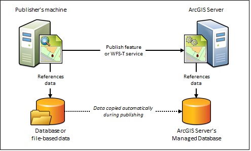
Registering data folders and databases with ArcGIS for Server is a new functionality in version 10.1. The purpose of registering data is to ensure your data is accessible to ArcGIS for Server or if it must be copied to the Server. When registering an enterprise database, we have the option of registering it as ArcGIS Server's Managed Database.


If you want to copy the data over from its primary location, and your service type (a feature or web feature (WFS) service) needs an enterprise geodatabase, you will need to register an enterprise geodatabase as managed.Managed_Database_Scenario.jpgA managed geodatabase is suggested if...
  • Publishers do not have access to an enterprise geodatabase and need to host feature services or transaction-enabled WFS services from filed-based data
  • Users will only work with data through a feature or WFS service
  • Your ArcGIS Server site is running in a cloud environment
A managed geodatabase is not suggested if…
  • If you want to publish a service type other than a feature or WFS-T service
  • If your data already resides in an enterprise geodatabase
  • If you want to publish database tables accessed through an OLE DB connection file (.odc)
  • If you want to synchronize changes between the publisher's machine and ArcGIS Server's Managed Database
Additional Resources

The documentation link below provides an example of good scenarios for when to use the managed database option with ArcGIS for Server.
Carrie D. - Support Services Analyst

more
1 0 1,226
by Anonymous User
Not applicable

esri2.pngHappy 2014! Esri is pleased to announce the release of ArcGIS 10.2.1. All customers current on maintenance may download it from the Esri Customer Care Portal.

The ArcGIS 10.2.1 setup package is designed to detect and upgrade an existing installation of the same ArcGIS 10.1 (including Service Pack 1 [SP1]) or 10.2 product. The settings for the installation location, license manager (for Concurrent Use), or authorization information (for Single Use or ArcGIS Server products) are retained in the upgrade. See the following reference guides for more information on installation upgrades, new installations, or installations over versions previous to 10.2.

The ArcGIS 10.2.1 release includes stability enhancements and improved functionality for the following ArcGIS products: ArcGIS for Desktop, ArcGIS for Server, ArcGIS Engine, Business Analyst Desktop, Portal for ArcGIS, and ArcGIS for Desktop and Server Extensions (Aviation, Maritime, Data Reviewer, Workflow Manager, Roads and Highways, and GeoEvent Processor).

For more information, please refer to ArcGIS Help: What's new in ArcGIS 10.2.1.Some useful links for installing ArcGIS 10.2.1 and upgrading your existing systems to ArcGIS 10.2.1:ArcGIS 10.2.1 Quick Start Guideshttp://resources.arcgis.com/en/help/quick-start-guides/10.2/License Manager Reference Guide http://resources.arcgis.com/en/help/install-guides/license-manager/10.2/ArcGIS for Desktop 10.2.1 Install Guidehttp://resources.arcgis.com/en/help/install-guides/arcgis-desktop/10.2/ArcGIS for Server 10.2.1 Install Guide (Windows)http://resources.arcgis.com/en/help/install-guides/arcgis-server/10.2/ArcGIS for Server 10.2.1 Install Guide (Linux)http://resources.arcgis.com/en/help/install-guides/arcgis-server-unix/10.2/Upgrading an earlier version of ArcGIS for Server (Windows)http://resources.arcgis.com/en/help/install-guides/arcgis-server/10.2/#/Existing_ArcGIS_for_Server_u...

*Note: Beginning at 10.2.1, ArcGIS Web Adaptor (IIS) can be installed alongside one other previous version of the Web Adaptor on the same machine; The version must match the version of ArcGIS for Server being used on the machine. Read more: http://resources.arcgis.com/en/help/main/10.2/0154/0154000005m8000000.htmUpgrading an earlier version of ArcGIS for Server (Linux)http://resources.arcgis.com/en/help/install-guides/arcgis-server-unix/10.2/#/Existing_ArcGIS_for_Ser...Portal for ArcGIS Install Guide (Windows) http://resources.arcgis.com/en/help/install-guides/arcgis-portal-windows/10.2/Portal for ArcGIS Install Guide (Linux) http://resources.arcgis.com/en/help/install-guides/arcgis-portal-linux/10.2/Upgrading Portal for ArcGIS 10.2 to 10.2.1 (Windows)*http://resources.arcgis.com/en/help/install-guides/arcgis-portal-windows/10.2/index.html#//01z700000...*Note: Migration to Portal for ArcGIS 10.2.1 from a pre-10.2 version is only supported through an Esri Professional Services agreement.ArcGIS 10.2.1 Uninstallation Utility for Windows http://resources.arcgis.com/en/help/uninstall-guides/1021FinalUninstallUtilityGuide.htmlRajeshwary K. - Online Support Resources


Correction: This post incorrectly listed "Location Analytics (Business Analyst (BA) Desktop, BA Server)" as part of the stability enhancements and functionality improvements included with the 10.2.1 release. This has been corrected to state, "Business Analyst Desktop".

more
0 0 2,575
RandallWilliams
Esri Regular Contributor

A question was brought to Support regarding how attachment uploads to feature services can be controlled. Specifically, the user asked if there was any way to limit the uploaded media MIME types in order to prevent malicious users from uploading executable applications, scripts, or other potentially malicious items to a GIS Server.

While ArcGIS for Server cannot control the actual content that is uploaded, it can control the MIME types (essentially the file extensions) and file sizes allowed to be uploaded as attachments to a feature service.

The workflow is formally described here in the ArcGIS for Desktop 10.2 help documentation, but it is not central in the ArcGIS for Server documentation. To that end, and because controlling this facet of ArcGIS for Server isn't discussed often, I wanted to highlight this option.

To make these edits, an ArcGIS for Server administrator can leverage the Administrator API. Settings for maximum upload size and allowed upload types are configurable on a per-service basis, and are not global changes. This allows for flexibility when deploying services for use with various applications.

By implementing maxUploadFileSize and allowedUploadFileTypes limits, an administrator can better control the content uploaded to an attachment enabled feature service.

more
0 0 304
AlexanderNohe1
Occasional Contributor III

Virtual Campus courses are an online community of users that are receiving training in a fully self-paced environment. Several different kinds of Virtual Campus courses can be taken at training.esri.com. Sometimes, after registering for a course, users are unable to view the course videos. When this happens, the following steps are recommended for users to troubleshoot the issue.

  1. Make sure a supported version of Adobe Flash player is installed. The operating system should be running version 9 or later. To find out what version is installed, go to http://www.adobe.com/software/flash/about. Flash player is not required to view the course videos, but it is required to view the live training seminars.
  2. The system must be running a supported browser. Esri currently supports Internet Explorer versions 7 through 11 as well as the most recent version of Firefox and Chrome. If the user has trouble with one browser, try viewing the video in a different browser.
  3. If the user is unable to view the video in multiple browsers, your associated organization may be blocking the server that hosts our training videos. Please work with your IT department to add an exception to your firewall to allow streaming from the following location: http://trainingmedia.esri.com/webcourses/*
  4. Resetting the browser cache may resolve the issue by clearing out old information that the browser is relying on.
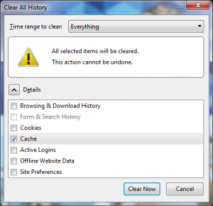
To reset the cache in Firefox:
  1. Press Ctrl + Shift + Del. This opens the Clear Recent History window.
  2. Make sure that Cache is checked, and press Clear Now.
ClearFireFox-300x290.pngTo reset the cache in Internet Explorer:
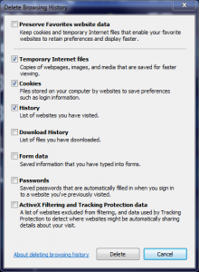
  1. Go to Tools (Alt + X) and then click on 'Internet options'.
  2. In the General tab, click on 'Delete...' under Browsing history.
  3. Make sure that Temporary Internet Files, Cookies, and History are checked. Press the Delete button.
ieDelete1-220x300.png

After performing the aforementioned steps, you should then be able to see the course videos. If you are otherwise unable to see the course videos, please contact Support with information on the following:
  • The specific error messages that are being received, and at which point in the process that the error is received
  • Which web browser (and version) is being used
  • Which operating system the computer is using

I hope that you all find this helpful! Thanks!Alexander N. - Support Services Analyst

more
0 0 425
LucasDanzinger
Esri Frequent Contributor

Since ArcGIS for Server 10.1 was released, the ArcPy library has been accessible through a 64-bit platform. In addition, the 64-bit Background Geoprocessing patch was released at 10.1 Service Pack 1, which allows ArcGIS for Desktop users to utilize geoprocessing in 64-bit. This means that if you have ArcGIS for Desktop and either ArcGIS for Server or the Background 64-bit Geoprocessing Patch installed, you have two different installs of Python 2.7.


The default paths for those are:

C:\Python27\ArcGIS10.1 - (32-bit)

C:\Python27\ArcGISx6410.1 - (64-bit)

This ArcGIS Resource Center blog post explains how to go about utilizing 64-bit geoprocessing in Python, and the ArcGIS Desktop Help has a very informative article on what the advantages are of running geoprocessing operations in 64-bit, as well as some of the limitations. Very briefly, one major advantage is that with 64-bit Background Geoprocessing, you are able to utilize larger amounts of RAM for large geoprocessing jobs that may have failed in 32-bit. However, some limitations that should be noted include processing with certain data types (such as personal geodatabase, Excel tables, and OLEDB) and using certain tools (Metadata conversion tools, geodatabase administration tools, to name a few).

The implications of this are that you must be aware of the 64-bit limitations when determining what version of Python you want to use. When running geoprocessing tools in ArcGIS for Desktop, the application knows that if you have the 64-bit patch installed and are using Background Geoprocessing on a tool or data type that does not support it, to just run in 32-bit instead. However, running a standalone script in 64-bit that calls for unsupported data types or tools results in an error.

Here are a few different scenarios to be aware of that may cause you some confusion with the two versions of Python, especially if you are executing the script against the 64-bit version unknowingly.
  • If the most recent version of Python that was installed was 64-bit, then the file association of the .py file will be with that 64-bit version. This means that if you double-click a Python script, or call a script from the command line/scheduled task without specifying which version of Python to use, it will run in 64-bit. This is due to how Windows assigns file associations. However, if the script uses any unsupported data types or tools, it will fail. Esri Knowledge Base Article 40838 explains this scenario, along with how to change the file association or explicitly call the version of Python that you want to use. I recommend that if you are going to set up your scripts to run as scheduled tasks, you first review the help documentation to determine if you should utilize the 32-bit or 64-bit version of Python, then create a Windows batch file to call whichever version of Python you wish to use. The scheduled task can then point to the .bat file instead of the Python script to avoid any confusion. This is explained in the above referenced KB article.
  • If running a Python script from an IDE, make sure to check what version of Python it (or its shortcut) is pointing to. For example, the 32-bit version of IDLE can be found at: C:\Python27\ArcGIS10.1\Lib\idlelib\idle.bat, and the 64-bit version can be found here: C:\Python27\ArcGISx6410.1\Lib\idlelib\idle.bat. Other IDEs such as PythonWin or PyScripter have different downloads for the 32-bit and 64-bit version, so be aware of the version of Python that the IDE you are working from uses. Just as mentioned in the above scenario, using the 64-bit version of Python on unsupported data or tools will result in an error. The version of Python can be checked by using the following command:

import sys

print(sys.version)

  • In some cases, uninstalling ArcGIS for Server or 64-bit Background Processing could result in the Python files (.py) not being associated with Python. If you do not specify to run your scripts with the 32-bit Python executable through the command line or a schedule task, there could be issues successfully running that script. Esri Knowledge Base Article 41185 discusses this scenario, along with how to resolve it.

There are undoubtedly more scenarios that could cause confusion with the 32-bit vs. 64-bit versions of Python. However, one thing to remember is that if your script works in ArcMap or ArcCatalog, but fails with an error in an IDE or as a schedule task, make sure to check the version of Python to be sure you are not using an unsupported data type or geoprocessing tool with 64-bit Python.Lucas D. - Desktop Support Analyst

more
2 0 12.2K
by Anonymous User
Not applicable

Having trouble copying an ArcGIS Viewer for Silverlight application from one machine to another? I would like to share with you how to transfer ArcGIS Viewer for Silverlight applications between machines.

Silverlight Viewer applications are not recognized by the Application Builder Home page if the applications are copied from another machine. To transfer ArcGIS Viewer for Silverlight applications from one machine (Computer A) to another (Computer B), follow the steps below.

  1. On Computer B, download the ArcGIS Viewer for Silverlight application. Refer to the Help documents below for the system requirements and installation guide:
  2. On Computer A , create a backup copy of the Builder and Apps folder. The default location for these folders is C:\inetpub\wwwroot.
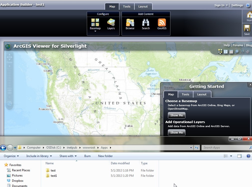
  3. On Computer A, open the Apps folder and copy the application to migrate (see the folder, "test", in our example below).
  4. On Computer B , place the copy of the application, "test", in the Apps folder. The default location for this folder is C:\inetpub\wwwroot.
  5. On Computer B, create a dummy application in the Application Builder and name it "test1" as in our example below.
  6. Deploy and save the application.
SLT_1.jpg

7. On Computer B, navigate to C:\inetpub\wwwroot\Builder\App_Data and open sites.xml in Notepad.

8. Replace the tags that contain the dummy application name (e.g. test1) with the name of the old application (e.g. test) and save the file.
<Name>test</Name>
<Url>http://servername:80/Apps/test</Url>
<PhysicalPath>C:\inetpub\wwwroot\Apps\test</PhysicalPath>SLT_2-300x96.jpg

9. On Computer B, open Application Builder. The old application (e.g. test) is displayed in the Application Builder Home page.

10. On Computer B, delete the dummy application (e.g. test1) from the Apps folder.

Additional References

Quick Start guide to the ArcGIS Viewer for SilverlightPhoebe H. - Server Support Analyst

more
0 0 258
by Anonymous User
Not applicable

ArcGIS Idea: Using the ArcGIS Server JavaScript API, I want to be able to create mobile web apps that work on mob...


One of the great benefits of the ArcGIS Ideas site is that everyone in the community can promote an idea they find interesting.  Another useful feature, one which we review just as seriously, is the comments section for each idea.  So when user ccabanero submitted an idea in March 2010 requesting that, using the ArcGIS Server JavaScript API, I want to be able to create mobile web apps that work on mob...many users agreed.  In addition, maxwellr added the comment that Esri needs a universal API that works on a variety of devices and platforms.  This made a lot of sense to us, too, especially our JavaScript team.

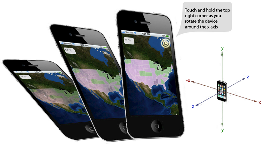
Esri’s JavaScript team has worked aggressively to add new samples and features to the JavaScript API to support application development on mobile devices.  They have designed a compact version of the API specifically focused on mobile development.createmobilewebapps.png


It’s now possible to add features like two finger pinch zooming, gesture recognition and GPS sensor data to applications. The JavaScript team has also created a mobile gallery to browse samples and has put together an interesting sample showing how to leverage CSS3 to add a compass feature to the map that honors device orientation.Additional Information and Samples:
Doug C. - User Advocacy Group

more
0 0 164
by Anonymous User
Not applicable

Windows 8 and Windows 2012 Server are now officially supportesrilogo-resize1.jpged starting at ArcGIS 10.1 SP1.  More details are available on the ArcGIS Resource Center Blog.

The Esri software system requirements pages have been updated to reflect this.Download ArcGIS 10.1 SP1 at your earliest convenience.Jessica G. - Online Support Resources


more
0 0 885
39 Subscribers