Esri Technical Support Blog - Page 2

cancel
Showing results for 
Show  only  | Search instead for 
Did you mean: 

Latest Activity

(383 Posts)
MeganSingleton
Occasional Contributor III

With almost every new release of ArcGIS Desktop and ArcGIS for Server, there are changes that aim to improve software quality and performance; sometimes, these changes require you to update your workflows. The improvements and deprecations made for geocoding in ArcMap 10.5 and ArcGIS Pro 1.4 may break some existing workflows or require you to prepare before installing ArcGIS 10.5. In this post, we'll give you an overview of these changes. 

1. Address locators stored in geodatabases are no longer supported, as specified in the deprecation notice for ArcGIS 10.4 and 10.4.1. As such, you must move or copy the address locators from the geodatabase to a file folder before installing ArcGIS Desktop and ArcGIS Server 10.5. By doing this, you'll avoid the following issues in ArcGIS 10.5:

  • Address locators currently stored in geodatabases do not display as inputs to tools nor are visible in ArcCatalog when viewing the geodatabase content.
  • Starting a geocode service published from an address locator that is stored in a geodatabase fails to create an instance and returns an error in the server logs.
  • Publishing an address locator stored in a geodatabase or an .sd file that references an address locator stored in a geodatabase directly to ArcGIS Server 10.5 will return an error in the server logs.

2. We made several improvements to the US Address locator styles, such as adding fields and reordering input fields used when building an address locator. However, these improvements break any existing workflows that use Python scripts and Model Builder models to create address locators. These issues occur without an error or warning message and render the address locators unusable. Furthermore, geocoding services created from these locators and used in web applications are impacted in ArcGIS 10.5.

To avoid these issues, update the field mapping in the scripts and models after installing ArcMap 10.5 and ArcGIS Pro 1.4 but before running the scripts and models. There are also additional output fields that display in the geocode result that are similar to the output fields of StreetMap Premium and the World Geocoding Service.

3. If it is necessary to continue using the US Address locator style from ArcGIS 10.4 to create address locators after installing ArcGIS Desktop 10.5, contact Esri Support Services to request access to the USAddress.lot.xml file.

For more information, please refer to this technical article index, which covers more detailed solutions to the aforementioned issues.
Shana B. - Product Engineer

more
0 0 2,375
Andrew--Johnson
Esri Regular Contributor

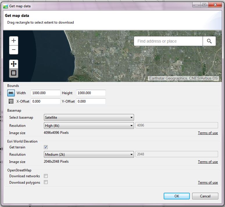
Get-map-data2.jpgThe CityEngine 2016.0 release was a ground breaking release. For those who are new to CityEngine and unfamiliar with the workflows, the new release cuts out a significant amount of time required to access and prepare data for use in CityEngine. For those who still want to use their own data…great!

You can find more information about preparing your data here.

For those who want a quick way of getting data and getting a CityEngine project up and running as quickly as possible, CityEngine 2016 is here to help with the Get map data wizard.

The Get map data wizard can be accessed by opening a scene in CityEngine and going to File > Get map data.  In the wizard, use the map to zoom to and select the area you want data from. The area selected can be from 500 m x 500 m to 100,000 m x 100,000 m. Three types of data can be grabbed by the wizard: Basemap, Esri World Elevation, and OpenStreetMap.

The basemap data is used as imagery (also referred to as texture) to be draped over the elevation layer. The basemap options allow you to select the basemap you want (Satellite, Streets, Topo, Dark Gray, or Light Gray), along with the image resolution. The resolution you select will determine the number of pixels the imagery has. The actual resolution of the imagery will depend on both the extent and resolution. For example, a 500 meter extent with a low resolution of 1024 pixels wide is less grainy than a 1,000 meter extent with the same resolution. As high resolution is not available across the globe, you may need to choose a lower resolution or larger area to get data. The Esri World Elevation will pull terrain data, or digital elevation model (DEM) data, from the Esri elevation service. OpenStreetMap data includes networks (streets) and polygons (building footprints).  OpenStreetMap is an open source, user-produced dataset, so coverage cannot be guaranteed, particularly for building footprints.

One thing to keep in mind when selecting data is that CityEngine is a memory intensive program and the larger the area and the higher the resolution, the more memory is required. If the computer has limited memory, you must consider that when selecting data to import.

With each new version of CityEngine, the software gets smarter, easier, and more groundbreaking. This blog only touched on the Get map data portion of the software, but there are more exciting features to check out, such as sharing scene packages, alembic modeling, and accessing data from ArcGIS Online. For a full list of new features, go here.


Rebecca R. & Andrew J. - Desktop Support

more
0 0 1,196
RebeccaRichman
Esri Contributor

With the addition of the Train Random Trees Classifier, Create Accuracy Assessment Points, Update Accuracy Assessment Points, and Compute Confusion Matrix tools in ArcMap 10.4, as well as all of the image classification tools in ArcGIS Pro 1.3, it is a great time to check out the image segmentation and classification tools in ArcGIS for Desktop. Here we discuss image segmentation, compare the four classifiers (Train Iso Cluster Classifier, Train Maximum Likelihood Classifier, random trees, and Support Vector Machine), and review the basic classification workflow.Image Segmentation

Before you begin image classification, you may want to consider segmenting the image first. Segmentation groups similar pixels together and assigns the average value to all of the grouped pixels. This can improve classification significantly and remove speckles from the image.Train Iso Cluster Classifier

The Iso Cluster is an unsupervised classifier (that is, it does not require a training sample), with which the user can set the number of classes and divide a multiband image into that number of classes. This classifier is the easiest of all the classifiers to use, as it does not require creating a training sample and can handle very large segmented images. However, this classifier is not as accurate as the other classifiers due to the lack of training sample.Train Maximum Likelihood Classifier

The Maximum Likelihood Classifier (MLC) uses Bayes' theorem of decision making and is a supervised classifier (that is, the classifier requires a training sample). The training data is used to create a class signature based on the variance and covariance. Additionally, the algorithm assumes a normal distribution of each class sample in the multidimensional space, where the number of dimensions equals the number of bands in the image. The classifier then compares each pixel to the multidimensional space for each class and assigns the pixel to the class that the pixel has the maximum likelihood of belonging to based on its location in the multidimensional space.Train Random Trees Classifier

One supervised classifier that was introduced with ArcGIS 10.4 is the random trees classifier, which breaks the training data into a random sub-selection and creates classification decision trees for each sub-selection. The decision trees run for each pixel, and the class that gets assigned to the pixel most often by the trees is selected as the final classification. This method is resistant to over-fitting due to small numbers of training data and/or large numbers of bands. This classifier also allows the inclusion of auxillary data, including segmented images and digital elevation model (DEM) data.Train Support Vector Machine Classifier

Support Vector Machine (SVM) is a supervised classifier similar to the MLC classifier, in that the classifier looks at multidimensional points defined by the band values of each training sample. However, instead of evaluating the maximum likelihood that a pixel belongs to a class cluster, the algorithm defines the multidimensional space in such a way that the gap between class clusters is as large as possible. This divides the space up into different sections separated by gaps. Each pixel is classified where it falls in the divided space.Image Classification Workflow:

With the addition of the Create Accuracy Assessment Points, Update Accuracy Assessment Points, and Compute Confusion Matrix tools in ArcGIS 10.4, it is now possible to both create and assess image classification in ArcMap and ArcGIS Pro.

The general workflow for image classification and assessment in ArcGIS is:

  1. If desired, use the Segment Mean Shift tool to segment your imagery.
  2. Create a training sample using the Image Classification toolbar (if you are using the Iso Cluster classification, you can skip this step).
  3. Use one of the four training tools (Train ISO Cluster Classifier, Train Maximum Likelihood Classifier, Train Random Trees Classifier, Train Support Vector Machine Classifier).
  4. Use the Create Accuracy Assessment Points tool on the classified image to create randomly placed points that have values extracted from the image.
  5. Either use the Update Accuracy Assessment Point tool to compare this classification to previously created classifications, or manually edit the points and visually assess a reference image.
  6. Use the Compute Confusion Matrix tool to create a confusion matrix from the accuracy points.
  7. Use the measures of accuracy (the user’s accuracy, producer's accuracy, and Kappa index) calculated by the confusion matrix to assess the classification. Make changes to the training sample, as needed, to improve the classification.

The best part about this six-step process is that it makes it pretty easy to compare different classification methods, and it’s often important to compare the different methods. Getting your training sites nailed down (step 2) is usually the toughest part, but steps 3 through 7 fly by since the analysis is done for you. In the end, you have several classified raster images to use in your work and can choose the best result based on your personal objectives.

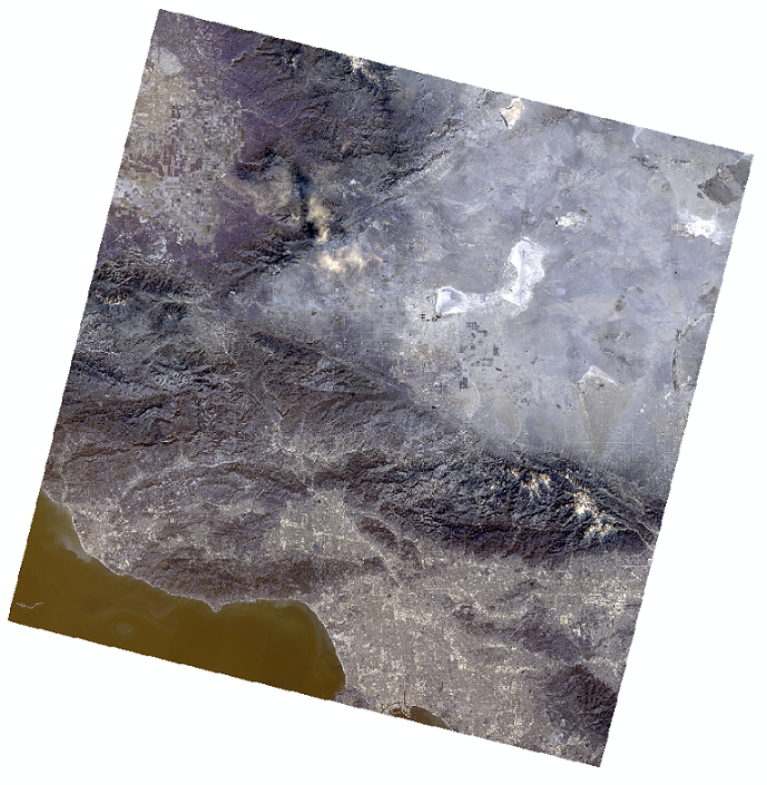
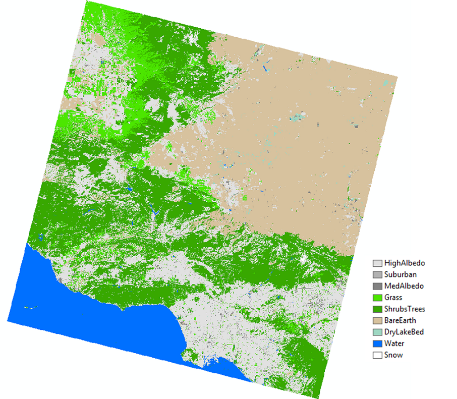
As an example, we used this workflow to classify a Landsat 8 image of the Ventura area in Southern California. We used the MLC, SVM, and Random Trees (RT) methods to classify a single Landsat 8 raster captured on February 15, 2016. We classified the image into nine classes and manually selected training samples and accuracy assessment (“ground truth”) points. Additionally, we used a segmented image as an additional input raster for each classifier. Once we classified the rasters, we computed a confusion matrix for each output to determine the accuracy of the classification when compared to ground truth points. The Kappa index in the Confusion Matrix gives us an overall idea of how accurate each classification method is.

The results showed that each method did pretty well in the classification when looking at the Kappa indexes, as well as based on a visual assessment. In order of accuracy (from the highest Kappa index to the lowest), we see that the SVM output was the most accurate (Kappa = 0.915), followed by Random Trees (Kappa = 0.88) and finally the MLC method (Kappa = 0.846).Confusion-Matrix-1024x186.png

We can see from the Confusion Matrix that some methods did better than others for specific classes. For example, the MLC didn’t do too well with Bare Earth classification, but RT and SVM weren’t too much better. This is great information for honing in on a better-classified image–now we know that we should focus on getting better Bare Earth training samples to improve our results. You could keep going with this until you get a really high accuracy for all classes, if that’s what you need for your analysis. If you need just a general idea of the area, you could just take what you get in Round 1! Check out what we got:

Source image:Source-Image.png

Classified Image:Classified-Image.png

Make sure to check out the new Image Classification Wizard with the release of ArcGIS Pro 1.3!
Julia L. and Rebecca R. - Desktop Support

more
2 0 6,096
GregoryLehner
Esri Contributor

This blog post provides the latest updates regarding deprecated features in ArcGIS 10.4 and in the recent release of ArcGIS 10.4.1.

With each release, the platforms and functionality supported in the ArcGIS platform are assessed and adjusted based on customer needs and technology trends. The purpose of the Deprecated Features for ArcGIS document is to provide as much advanced notice as possible regarding these changes.

For more information on our deprecation plans, refer to the following PDF document, Deprecated Features Plan for ArcGIS 10.4 and 10.3.x Series (this deprecation plan is also available at the following technical article in the Esri Support Knowledge Base). The documentation linked above provides additional information about each note below, in addition to recommendations of alternative workflows and applications.

Here are some of the major changes in the update for ArcGIS 10.4 and 10.4.1:

  • The ArcGIS Engine SDK for Cross-platform C++ will not be supported after ArcGIS 10.4.1.
  • ArcGIS 10.4.1 will be the last release of Engine Linux. ArcGIS 10.4.x for Engine Linux will be supported till 2022.
  • ArcGIS 10.4.1 (and ArcGIS Pro 1.3) will be the last release that supports the PostgreSQL 9.2.x series.
  • ArcGIS 10.4.1 for Server will be the last release to include support for the Mobile Content Server and Mobile Data Access features in the GIS server.
  • ArcGIS 10.5.x for Server will be the last major release series to include support for the Search Service functionality in the GIS server.
  • ArcGIS 10.2.1 for Windows Mobile is the last release. No additional features, functionality, or performance / stability updates will be released for this application.
  • ArcGIS 10.4 is the last release that supports the Oracle Spatial GeoRaster data type.


Gregory L. - Online Support Resources

more
0 0 1,249
GregoryLehner
Esri Contributor

Update, 2 June 2016: Google Chrome 51.0.2704.79 was just released; it fixes the change that caused a blank screen for ArcGIS Online, Portal for ArcGIS, and applications built with the ArcGIS API for JavaScript. If you are affected by this, please click the Customize and control Google Chrome button and navigate to "Help > About Google Chrome" to force an update check and upgrade to this latest patch level.

The previous version was 51.0.2704.63, and the fixed version is 51.0.2704.79.

Update, 27 May 2016: KB 13156 has been published on the Support website to provide additional information about this issue.

---------------------

Google released an update to Google Chrome (version 51), which was pushed out to the public on Wednesday, May 25th. Unfortunately, this update included a change that impacts anyone using Google Chrome to access ArcGIS Online or Portal for ArcGIS versions 10.3, 10.3.1, 10.4, or 10.4.1.

This change impacts many apps built on the ArcGIS API for JavaScript (versions 3.8 - 3.16), several subsets of custom apps built by users, partners, and Esri Professional Services (for example, any app that uses the feature table or an analysis widget), and, most notably, the "home app" in ArcGIS Online and Portal for ArcGIS.

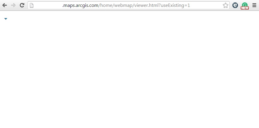
You may be seeing a screen similar to this after logging in: a blank screen with few or no elements.

googlechrome51.jpg

What you can do:

If you are using Google Chrome to access ArcGIS Online, the above listed Portal for ArcGIS versions, or apps built with the above-listed versions of the ArcGIS API for JavaScript, please turn off auto-update in your Chrome browser now. If Chrome was updated, you will need to temporarily use another browser (such as Internet Explorer or Mozilla Firefox) until patches have been released.

What Esri is doing:

  • The ArcGIS Online team is preparing fixes that will go live this evening.
  • We are still working on a solution for Portal for ArcGIS.
  • Developers using the hosted version of the JavaScript API are unaffected, as it has already been patched.
  • We are working on a solution for JavaScript API developers that use either a custom build of the API or use it locally.


We will provide updates at the top of this blog post regarding Portal for ArcGIS and ArcGIS API for JavaScript as soon as we have more information. A technical article has been released for this issue, KB 13156, which provides some additional detail about this problem.

If you have run into any problems as a result of this bug that impact your workflows, please contact Esri Support Services at 1-888-377-4575.


Gregory L. - Online Support Resources

more
0 0 2,320
JuliaLenhardt1
New Contributor III

With the release of ArcGIS 10.4 comes a brand new geoprocessing tool that allows you to update your enterprise geodatabase license efficiently through ArcGIS for Desktop. The Update Enterprise Geodatabase License tool is now included in the Geodatabase Administration toolset in the Data Management toolbox.

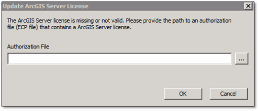
In previous versions, you may have attempted to connect to your enterprise geodatabase, only to receive an invalid or missing ArcGIS Server license error, such as the following:

GDBLicenseError.png


In ArcGIS 10.4, you can use the new geoprocessing tool that allows you to update your license file, and you can even incorporate the tool into a Python script to automate the process of updating your file, as long as you have a valid license file on hand. You can even schedule the Python script to run at certain intervals using your operating system's scheduling application.

Check out the help documentation on this new tool, and I'll throw in the link to obtain a valid Authorization File tool, just for fun:
Julia L. - Geodata Support Analyst

more
1 0 2,911
AndrewOrtego
New Contributor III

My name is Andrew--you can call me Drew--and I’m a Desktop Support Analyst with Esri Support Services. If you’ve ever called us to talk about a Python issue, you’ve probably spoken to me! I get a lot of positive feedback from the people I speak with about troubleshooting Python scripts, and I’d like to share the most popular advice I have to give. Whether you’re learning to code for the first time, or just getting started with the ArcPy site package, these tips and tricks should help you get your script back on track and closer to completion.

Since we get a lot of different Python-related calls in Support, I’ve collected the six most common requests into the scenarios below. Use these scenarios to help you decide which workflow applies to your current problem.1. You’re getting started with Python for the first time and aren't sure how to start learning it.

You’re in luck! I wrote a blog about this very problem about a year ago! That blog contains tutorials that help anyone learn to code in Python and links to many free online resources--these resources are organized by learning styles, so there’s something for everyone.Seven easy ways to start learning Python and ArcPy2. Your script returns the error message: “ImportError: No module named arcpy."

This is the most frequent issue Esri Support encounters when troubleshooting ArcPy. The error message is produced when the ArcPy site package is installed incorrectly, but it’s very easy to fix. There are a number of causes that can interplay to produce this error, so it is best to refer to Knowledge Base article 43846, Problem: Unable to import arcpy, for more details when troubleshooting this type of issue.

If that article doesn’t provide a solution, I recommend speaking with your IT team to determine if there’s any reason to expect that you wouldn’t have full read or write permissions to the directories you’re accessing. If you’re working on a remote machine, attempt to troubleshoot directly on the machine installed with ArcGIS for Desktop.3. The script you wrote works everywhere except in the Windows Task Scheduler.

Since Esri didn’t create the Windows Task Scheduler (WTS), this is a tricky one to troubleshoot with Esri Support. However, the Knowledge Base article, Windows Task Scheduler will not run a Python script, will help you verify whether the issue is with the WTS, the Python installation, or your script.4. You want to start creating a script, or you have started creating a script and need to move forward, but are getting stuck.

In this case, you’ve got a goal in mind, you can make it work without Python, but you need to code. Where do you go? The most important step is verifying that you have a desirable outcome in mind. With a goal in mind, you can break your problem down into logical steps.

For example, let’s say you want to write a script that will clip one feature to another. First, try it in ArcMap. Does your data give you the expected results? Are you positive that this is the workflow you need? If so, then it’s time to review the documentation for the Clip tool and get the Python syntax that helps you do this. Check out the ArcGIS for Desktop Help page for this information, conveniently found here:Clip Tool Reference

Notice that the Syntax section tells you the name of the ArcPy function associated with the Geoprocessing tool, as well as the parameters needed (plus optional parameters) to make the function run properly. Keep an eye on those data types-- they can be tricky sometimes!

The Code Sample section is very useful for those of us who like to learn by example, so take a look at that section before you start coding; it may help demonstrate how to use the function even better than the Syntax section.5. Your script is not producing the expected results, and/or you suspect an ArcPy function is causing a problem.

I see this problem all the time, and I’ve come up with a solution that never fails to solve it. The following steps should help you learn more about the source of the issue.a. Whether you’re getting an error message, or your output is incorrect, you’ll benefit from isolating the code that is causing a problem. Make a script that demonstrates the “smallest testable case”.b. Troubleshooting a single ArcPy function is a lot easier than troubleshooting a 2,000-line script. Put the suspected function into its own .py file (and maybe even create some small test data), and verify that you’re getting the expected output from that function.c. Add some other code, if needed, but don’t forget that the purpose of this test is to isolate the issue down to a single line in your larger script. Any problem can be simplified, and taking a step back, instead of pushing forward, will save you a lot of debug time.6. Your code is not working, and you feel comfortable using Python to isolate the issue.

Here are some more advanced tips for troubleshooting your script:a. Test the function both in and out of the ArcMap or ArcCatalog Python console. This will indicate whether or not an integrated development environment (IDE) is properly accessing the Python.exe file installed with ArcGIS for Desktop. ArcMap and ArcCatalog should always be able to run ArcPy functions. If these programs cannot run ArcPy functions, a reinstallation might be necessary.b. Test the function with different data. This indicates whether the issue is data-specific or not.c. Check the online documentation specific to the version of ArcGIS for Desktop you are using. With each new release, some updates are made to the ArcPy site package that change the behavior of ArcPy’s functions.d. If you suspect that a function is incorrectly written, run the function in ArcMap or ArcCatalog, and use the Geoprocessing Results window to copy the Python version of that geoprocessing tool into the Windows Clipboard. Paste the results into your favorite IDE, and compare your code to the Esri-made Python snippet. It might be a little messier than your code, but comparing the two could give you a hint as to where the problem can be found.

I hope that helps! Remember, coding is a skill, and it can be really confusing sometimes. Be patient with yourself, and you’ll soon have all these troubleshooting steps integrated into each script-writing session you embark upon. Don’t be afraid to search the internet for solutions that others have come up with, and of course, feel free to give us a call here at Esri Support if you are current on maintenance. Good luck, and happy coding!


Andrew O. - Desktop Support Analyst

more
4 2 1,890
JuliaLenhardt1
New Contributor III

Are you running ArcGIS 10.0 for some of your GIS needs? We know, it’s a great platform, but it’s time to move onward and upward. Over the last five years, Esri has developed greater and more powerful functionalities across all platforms, moving from ArcGIS 10.0 all the way to the upcoming release of ArcGIS 10.4. These upgrades have come with more tools, more efficient processing, and more features that allow you to create and share the data and maps you need. If you haven’t upgraded your applications and geodatabases yet, it’s time to start planning. Starting in January 2016, Esri will no longer provide Standard Support for ArcGIS 10.0. Of course, we at Esri Support are more than happy to help with any upgrade questions you may have, and the experience will only be smoother if you don’t wait until the last minute to upgrade. We can walk you through the workflow from start to finish and are here if you run into any issues. The upcoming deprecation of support includes:

  • ArcGIS for Desktop 10.0
  • ArcGIS Server 10.0
  • ArcSDE 10.0 and enterprise geodatabases in version 10.0
  • ArcIMS
  • ArcInfo Workstation 
For more information, check out the following links:Esri Product Life Cycle Support Policy Deprecation Plan for ArcGIS 10.0 and ArcGIS 10.1ArcIMS Product Life Cycle Support StatusArcInfo Workstation Product Life Cycle Status
Julia L. - Geodata Support Analyst

more
0 0 527
by Anonymous User
Not applicable

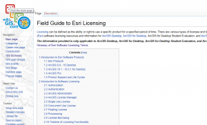
Coming to Esri (and to California) for the first time four months ago as a very hopeful intern, I was excited at the prospect of completing a project that would have a meaningful impact on those who use ArcGIS for Desktop products. Esri did not disappoint, as I dove headfirst into my project from day one, learning the ins and outs of the ArcGIS for Desktop licensing model. There was one main goal: how to merge the vast amount of Esri resources related to licensing ArcGIS for Desktop into a central location and create a guide for finding information. Wiki.GIS.com became my tool to create this document.

I got very lucky at Esri, as my team and mentors often threw me a lifeline when I needed it—this helped me make sense of information and keep my focus on the end goal: helping users. The end result was better than I could have imagined: a field guide to Esri software licensing that was comprehensive in the amount and types of resources offered.The Field Guide to Esri Licensing on Wiki.GIS.com is the culmination of an idea to aid users in their quest to understand and implement licensing. The guide provides information for all different kinds of users: new users, experienced users, those who have a specific problem or who need to find answers on-the-fly, as well as those seeking general knowledge. In truth, the guide was easy to write once I had the information. Since I was new to licensing, it was understandable how people may have trouble with certain problems, terminology, or concepts.2015-07-30_16-05-55-300x181.png

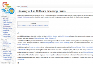
Licensing terms were just as important to define; what good would it be having a guide to licensing if users could not understand the meaning of important definitions contained within? Thus, the Glossary of Esri Software Licensing Terms was born. The glossary provides a wide range of licensing terms, the majority of which are linked to the Field Guide to Esri Licensing. Users may click certain words in the field guide to quickly look up a definition from the glossary—this provides a transparent window into the technical world of licensing.2015-07-30_16-06-181-300x205.png

The field guide features resources for ArcGIS Desktop (versions 8.0 - 10), ArcGIS for Desktop (versions 10.1 - 10.3.1), as well as ArcGIS Pro. Many resources are conveniently hosted in tables, as well. The tables provide the name of the resource referenced, the topics of the resource, and a link to the source. Topics include but are not limited to authorization, the ArcGIS Administrator, the ArcGIS Licensing Manager, provisioning, evaluation (student) licensing, and more. There is a body of text associated with each table that briefly defines certain licensing concepts; however, the guide is meant to be more of a web map for users who may be at a crossroads in their licensing quest and need to figure out where to go.

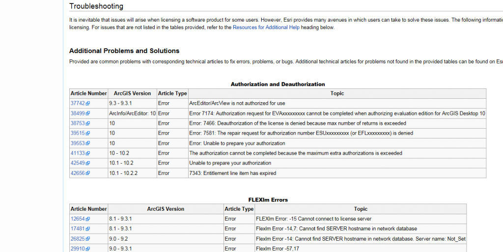
The field guide also features a plethora of Esri technical articles organized in tables to act as a troubleshooting reference point for licensing ArcGIS for Desktop. The tables are labeled by topic to ensure users can easily navigate the document and find an article that meets their needs. These tables provide key pieces of article information: a clickable article ID number that links to the respective article, the specific range of applicable versions, article type (How To, Bug, Error, etc.), as well as the title or topic. These tables quickly guide users to the most relevant technical articles, decreasing time spent finding the best solution.2015-07-30_16-05-32-1024x513.png

After completing the Field Guide to Esri Licensing and the Glossary of Esri Software Licensing Terms, I realized how easy it could have been for someone to get lost in the technical aspects of licensing. For the ArcGIS community, this guide will make the process of finding licensing information much more navigable while also highlighting the strength of online content—I came to value the quality of Esri’s online resources during my time as an intern with Support Services.


Carissa S. - Online Support Resources

more
0 0 454
GregoryLehner
Esri Contributor

The ArcGIS 10.3 release includes the new Space Time Pattern Mining toolbox for analyzing data distributions and patterns in the context of both space and time in ArcMap and ArcGIS Pro. Unfortunately, the initial release contains a substantial logic flaw in the Create Space Time Cube tool which makes the results from the Emerging Hot Spot Analysis tool unreliable.

We have corrected this problem in ArcMap 10.3.1 and ArcGIS Pro 1.1, and we are providing the patches below for your immediate use. Regrettably, you must rerun all of your previous analyses using the provided fix. Internally we have enhanced our validation strategies to ensure this is not a recurring error.


Lauren B. - Spatial Statistics Team

more
0 0 585
39 Subscribers