- Home
- :
- All Communities
- :
- Industries
- :
- Education
- :
- Higher Education
- :
- Higher Education Questions
- :
- Re: Building Mosaic in Weighted Overlay Service To...
- Subscribe to RSS Feed
- Mark Topic as New
- Mark Topic as Read
- Float this Topic for Current User
- Bookmark
- Subscribe
- Mute
- Printer Friendly Page
Building Mosaic in Weighted Overlay Service Toolbox for GeoPlanner doesn't work
- Mark as New
- Bookmark
- Subscribe
- Mute
- Subscribe to RSS Feed
- Permalink
- Report Inappropriate Content
For a project in university I’m supposed to create a #Weighted Overlay Service for geoplanner for arcgis. I’m using ArcGIS for Desktop 10.4.1 and the #Weighted Raster Overlay Service Toolbox which I downloaded from Github for my data preprocessing.
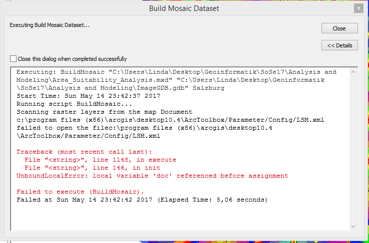
The last step of the preprocessing I’m supposed to use the Build Mosaic Dataset tool, which fails to execute. I don’t know what the error message means.
What I did so far on all my datasets is:
1. Clip them to my Area of Interest.
2. Project them to Web Mercator Auxiliary Sphere.
3. Check and Repair Geometry.
4. Calculate Euclidean Distance (Because I want to figure out spaces within my city which are close to Kindergartens, Schools, Playgrounds, but far from highly frequented roads). By using the Calculate Euclidean Distance tool, my data is transformed from vector to raster.
- I made sure that in my Environment Settings the Processing Extent and the cell size was the same for every layer.
5. Next, I performed Calculate Statistics for my Area of Interest
6. To handle NoData cells, I used the Raster calculator where I entered e.g. the expression Con(IsNull("EucDistKinder"),9999,"EucDistKinder"), to exchange NoData values to 9999.
7. Then I used Raster to Other Format to convert my layers to geoTIFF.
After that comes the difficulty:
I’m supposed to use the #Configure Raster Fields tool, from the Weighted Raster Overlay Service toolbox. I shall enter Input ranges by the pattern min. value included, max. value excluded (0,201,201,401...). This range should match my classification, but as you can see in the image, ArcMap shows me that my ranges go from 0 to 200, and then the next class starts at 200 too.
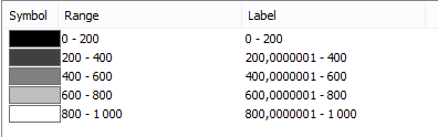
Is this also displayed as min. included, max. excluded? Plus, it is labeled as starting from 200,0000001. As I can only enter whole numbers in the Input Range I want my classification to go from 0 to 200 and then from 201 to 400. Is there a way I can force ArcMap to classify like that? Because I think that might be the reason why I can’t build a Mosaic Dataset in the end.
As I already spent ages figuring out my mistakes, I would be super glad if someone could help me or recommend documentation except for https://doc.arcgis.com/en/geoplanner/documentation/use-your-data.htm, which I’m currently using as my guide.
Thank you a lot,
Linda
Solved! Go to Solution.
Accepted Solutions
- Mark as New
- Bookmark
- Subscribe
- Mute
- Subscribe to RSS Feed
- Permalink
- Report Inappropriate Content
Hi Linda,
Sorry to hear that you are running into difficulties. We just had our annual user conference in San Diego and I could not reply until now.
Regarding this issue: Local variable doc referenced before assignment
When you download and extracted the .zip from github, did you copy the toolbox to another location? As in, did you move it from weighted-raster-overlay-service-toolbox-master\weighted-raster-overlay-service-toolbox-master\WROS\Tools to another folder and then execute it from that folder? If you did, this may have caused the problem as it has dependencies on some of the files in the other folders within the WROS directory.
Regarding the min inclusive - max exclusive question: Try this string in the Configure Raster Fields tool -
0,201,201,401,401,601,601,801,801,1001. Think of the raster layer classification as a guideline. You're really just creating a min-inclusive, max-exclusive string for the remap function. In the range labels parameter of the Configure Raster Fields tool, use some qualitative labels like Very Low, Low, Medium, High, Very High. If you must use values in the labels, remove the comma (as your separator). The actual data ranges will display in the widget.
Rob
- Mark as New
- Bookmark
- Subscribe
- Mute
- Subscribe to RSS Feed
- Permalink
- Report Inappropriate Content
Hello Rob,
Thank you so much for your answer, it actually solved my problem!
But now I have another issue:
I was able to access my Service in GeoPlanner and to design a model, saved it - it shows up in my contents layers, I can also "Zoom to", but it won't show up in the map (the transparency is not the problem)...Do you have an idea what could be the matter here?
Thanks,
Linda
- Mark as New
- Bookmark
- Subscribe
- Mute
- Subscribe to RSS Feed
- Permalink
- Report Inappropriate Content
Hi Linda,
Thanks for responding. Here are a few things to try:
- Try to generate a model using 1 layer from your service. For example, say you have a service with three layers, slope, habitat and road density. In the modeler in GeoPlanner (or Web Appbuilder), choose 1 layer from the service, weight it to 100% and click Save (or Run in Web AppBuilder). Do you get a result? Try all layers to verify they display something.
- The process of sharing the mosaic dataset to ArcGIS Enterprise (Server) will create an item in your organization. Sign into that org and add that item to a new web map. You should see your mosaic in the map. You should also be able to open the mosaic's attribute table. Doing this will verify that the item displays in ArcGIS Online as a service.
- For ArcGIS 10.4x or 10.3x, you need ArcGIS Server Advanced. You'll want to make sure that Advanced has the spatial analyst available.
Finally, we do offer consulting assistance to help you prototype and host these analysis services. Let me know if you're interested.
Rob
- Mark as New
- Bookmark
- Subscribe
- Mute
- Subscribe to RSS Feed
- Permalink
- Report Inappropriate Content
Where do u find the tool to be download from Github?