Turn on suggestions
Auto-suggest helps you quickly narrow down your search results by suggesting possible matches as you type.
Cancel
- Home
- :
- All Communities
- :
- Industries
- :
- Education
- :
- Education Blog
- :
- Walking On Water? Reflections on Resolution and Sc...
Walking On Water? Reflections on Resolution and Scale
Subscribe
252
0
11-29-2012 11:39 PM
- Subscribe to RSS Feed
- Mark as New
- Mark as Read
- Bookmark
- Subscribe
- Printer Friendly Page
- Report Inappropriate Content
11-29-2012
11:39 PM
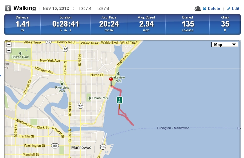
I recently gave presentations at the University of Wisconsin Milwaukee for GIS Day, and took the opportunity, as most geographers would, to get out onto the landscape. I walked on the Lake Michigan pier at Manitowoc, enjoying a stroll in the brisk wind to and from the lighthouse there, recording my track on my smartphone in an application called Runkeeper. When my track had finished and been mapped, it appeared as though I had been walking on the water!
Map of my walk from Runkeeper.com.
Photograph of my destination: The lighthouse at the North Pier, Manitowoc, Wisconsin.
According to my map, I walked on water. Funny, but I don’t recall even getting wet! It all comes down to paying close attention to your data, and knowing its sources. Showing these images provides a teachable moment in a larger discussion on the importance of scale and resolution in any project involving maps or GIS. In my case, even if I scrolled in to a larger scale, the pier did not appear on the Runkeeper’s application’s base map. It does, however, appear in the base map in ArcGIS Online. In the book that Jill Clark and I wrote entitled The GIS Guide to Public Domain Data, we discuss how scale and resolution can be conceptualized and put into practice in both the raster and vector worlds. We cite examples where neglecting these important concepts have led not only to bad decisions, but have cost people their property and even their lives. Today, while GIS tools allow us to instantly zoom to a large scale, the data being examined might have been collected at a much smaller scale. Much caution therefore needs to be used when making decisions when the analysis scale is larger than the collection scale.
What example have you used in class that well illustrates the importance of scale and resolution?
- Joseph Kerski, Esri Education Manager
You must be a registered user to add a comment. If you've already registered, sign in. Otherwise, register and sign in.
About the Author
I believe that spatial thinking can transform education and society through the application of Geographic Information Systems for instruction, research, administration, and policy.
I hold 3 degrees in Geography, have served at NOAA, the US Census Bureau, and USGS as a cartographer and geographer, and teach a variety of F2F (Face to Face) (including T3G) and online courses. I have authored a variety of books and textbooks about the environment, STEM, GIS, and education. These include "Interpreting Our World", "Essentials of the Environment", "Tribal GIS", "The GIS Guide to Public Domain Data", "International Perspectives on Teaching and Learning with GIS In Secondary Education", "Spatial Mathematics" and others. I write for 2 blogs, 2 monthly podcasts, and a variety of journals, and have created over 5,000 videos on the Our Earth YouTube channel.
Yet, as time passes, the more I realize my own limitations and that this is a lifelong learning endeavor and thus I actively seek mentors and collaborators.
Related Articles
Walking on Water? Revisiting reflections on resolution and scale
JosephKerski
Esri Notable Contributor
0 Kudos
0 Comments
Labels
-
Administration
38 -
Announcements
44 -
Career & Tech Ed
1 -
Curriculum-Learning Resources
178 -
Education Facilities
24 -
Events
47 -
GeoInquiries
1 -
Higher Education
518 -
Informal Education
265 -
Licensing Best Practices
46 -
National Geographic MapMaker
10 -
Pedagogy and Education Theory
187 -
Schools (K - 12)
282 -
Schools (K-12)
184 -
Spatial data
24 -
STEM
3 -
Students - Higher Education
231 -
Students - K-12 Schools
85 -
Success Stories
22 -
TeacherDesk
1 -
Tech Tips
83
- « Previous
- Next »