Turn on suggestions
Auto-suggest helps you quickly narrow down your search results by suggesting possible matches as you type.
Cancel
- Home
- :
- All Communities
- :
- Industries
- :
- Education
- :
- Education Blog
- :
- Spatial Citizenship Competencies for Teacher Educa...
Spatial Citizenship Competencies for Teacher Education
Subscribe
471
0
01-28-2016 10:59 PM
- Subscribe to RSS Feed
- Mark as New
- Mark as Read
- Bookmark
- Subscribe
- Printer Friendly Page
- Report Inappropriate Content
01-28-2016
10:59 PM
What is a spatial citizen? It has been defined as "An individual who has the motivation, knowledge, skills, and competencies to access and reason with geo-information in order to participate in democratic processes." (Adapted from I. Gryl, T. Jekel, and K. Donert, 2010). Are we as the geospatial education community, encouraging students to become spatial citizens? Emerging research on spatial citizenship seeks to understand how the education community can best do that.
But how can the geospatial education community best equip educators so that they can promote such participation? Most researchers agree that helping students to develop geotechnology skills is only part of the solution. Skills in spatial thinking, coping with geospatial information, communicating with that information, and developing critical thinking skills with regard to problem solving and to data are all just as important as the technical skills. Indeed, all of these are skills we have written about in this blog. How can educators new to the field develop competencies to teach these skills, and how can experienced educators continue to sharpen their skills?
To help answer these questions, researchers Uwe Schulze, Inga Gryl, and Detlef Kanwischer developed a spatial citizenship competence model for teacher education and training. It includes instrumental competence (such as methodological and technological skills), interpersonal competence (such as interaction and cooperation skills), and systemic competence (such as how to teach these skills most effectively). The model contains six major dimensions: 1. Technology and methodology. 2. Reflection. 3. Communication. 4. Spatial domain. 5. Citizenship education. 6. Implementation strategies.
The authors argue that such a model shifts from focusing on subject-specific GIS content to the use of geospatial technology and spatial representations within everyday digital geomedia environments in a multifaceted, reflective way. They go on to say that digital geomedia is a new interdisciplinary language that is spoken in a variety of subjects. I don't think we are quite to the point where this is universally recognized throughout education and society, but there are encouraging signs.
For more information, see the review we wrote about the book Learning and Teaching with Geomedia, which includes chapters about this topic, and the Spatial Citizenship website.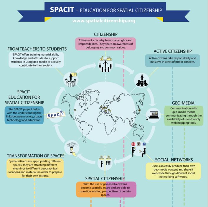
Spatial Citizenship.
You must be a registered user to add a comment. If you've already registered, sign in. Otherwise, register and sign in.
About the Author
I believe that spatial thinking can transform education and society through the application of Geographic Information Systems for instruction, research, administration, and policy.
I hold 3 degrees in Geography, have served at NOAA, the US Census Bureau, and USGS as a cartographer and geographer, and teach a variety of F2F (Face to Face) (including T3G) and online courses. I have authored a variety of books and textbooks about the environment, STEM, GIS, and education. These include "Interpreting Our World", "Essentials of the Environment", "Tribal GIS", "The GIS Guide to Public Domain Data", "International Perspectives on Teaching and Learning with GIS In Secondary Education", "Spatial Mathematics" and others. I write for 2 blogs, 2 monthly podcasts, and a variety of journals, and have created over 5,000 videos on the Our Earth YouTube channel.
Yet, as time passes, the more I realize my own limitations and that this is a lifelong learning endeavor and thus I actively seek mentors and collaborators.
Labels
-
Administration
38 -
Announcements
45 -
Career & Tech Ed
1 -
Curriculum-Learning Resources
179 -
Education Facilities
24 -
Events
47 -
GeoInquiries
1 -
Higher Education
519 -
Informal Education
266 -
Licensing Best Practices
46 -
National Geographic MapMaker
17 -
Pedagogy and Education Theory
187 -
Schools (K - 12)
282 -
Schools (K-12)
185 -
Spatial data
24 -
STEM
3 -
Students - Higher Education
231 -
Students - K-12 Schools
86 -
Success Stories
22 -
TeacherDesk
1 -
Tech Tips
83
- « Previous
- Next »