Turn on suggestions
Auto-suggest helps you quickly narrow down your search results by suggesting possible matches as you type.
Cancel
- Home
- :
- All Communities
- :
- Industries
- :
- Education
- :
- Education Blog
- :
- Introduction to Landsat Thematic Bands Web Mapping...
Introduction to Landsat Thematic Bands Web Mapping Application
Subscribe
1431
0
07-09-2015 11:56 PM
- Subscribe to RSS Feed
- Mark as New
- Mark as Read
- Bookmark
- Subscribe
- Printer Friendly Page
- Report Inappropriate Content
07-09-2015
11:56 PM
Teaching remote sensing? This web mapping application can be a very useful teaching tool. The web mapping application covers the whole planet, with mapping services that are updated daily with new Landsat 8 scenes.
Access many band combinations and indices by hovering over the tools to the left of the map image and selecting among the following:
The Time tool for different indices at larger scales based on a user-selected location enables examination of changes over years or over seasons. It also provides temporal profiles for NDVI (Normalized Difference Vegetation Index), NDMI (Normalized Difference Moisture Index) and an Urban Index. The Identify tool enables access to information on the date, cloud cover, and a spectral profile about each scene. The Bookmark tool allows access to pre-selected interesting locations.
The application is written using Web AppBuilder for ArcGIS accessing image services using the ArcGIS API for JavaScript, with access to the following Image Services:
These services can also be accessed through the public Landsat on AWS group on ArcGIS Online. You truly have "the world at your fingertips" because you can add these services as layers to your own maps or maps from others, or you can use the above web mapping application as a standalone map. But there is a third option: The web mapping application is also embedded on the Unlock Earth's Secrets page, which also is useful for instruction, with featured places around the planet scrolling through time.
Think of the above as solid introductory segments to get your students interested in the topic of remote sensing. These maps and applications require very little geospatial technology skills, allowing you to focus on concepts and principles while exploring some truly engaging content and places.
To dig deeper, delve into the many powerful remote sensing functions available in ArcGIS Desktop. One source for engaging, hands-on activities, is Kathryn Keranen and Bob Kolvoord's book Making Spatial Decisions Using GIS and Remote Sensing: A Wo....
Give these resources a try!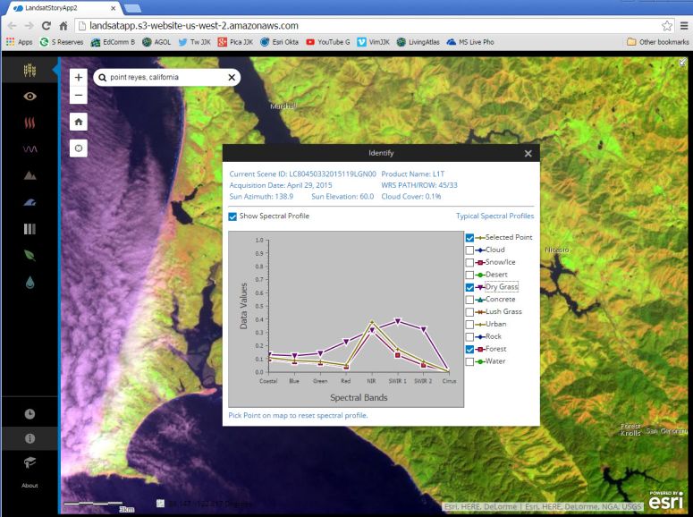
Access many band combinations and indices by hovering over the tools to the left of the map image and selecting among the following:
- Agriculture: Highlights agriculture in bright green. Bands 6,5,2
- Natural Color: Sharpened with 25m panchromatic band. Bands 4,3,2+8
- Color Infrared: Healthy vegetation is bright red. Bands 5,4,3
- SWIR (Short Wave Infrared): Highlights rock formations. Bands 7,6,4
- Geology: Highlights geologic features. Bands 7,4,2
- Bathymetric: Highlights underwater features. Bands 4,3,1
- Panchromatic: Panchromatic image at 15m. Band 8
- Vegetation Index: Normalized Difference Vegetation Index (NDVI). (Band5-Band4)/(Band5+Band4)
- Moisture Index: Normalized Difference Moisture Index (NDMI). (Band5-Band6)/(Band5+Band6)
The Time tool for different indices at larger scales based on a user-selected location enables examination of changes over years or over seasons. It also provides temporal profiles for NDVI (Normalized Difference Vegetation Index), NDMI (Normalized Difference Moisture Index) and an Urban Index. The Identify tool enables access to information on the date, cloud cover, and a spectral profile about each scene. The Bookmark tool allows access to pre-selected interesting locations.
The application is written using Web AppBuilder for ArcGIS accessing image services using the ArcGIS API for JavaScript, with access to the following Image Services:
- Landsat Multispectral on AWS – 8-band multispectral 30m resolution image services and functions that provide different band combinations and indices.
- Landsat Pan-sharpened on AWS – Panchromatic-sharpened imagery; 4-band (Reg, Green, Blue and NIR); 30m resolution.
- Landsat Panchromatic on AWS – Panchromatic imagery; 15m resolution.
These services can also be accessed through the public Landsat on AWS group on ArcGIS Online. You truly have "the world at your fingertips" because you can add these services as layers to your own maps or maps from others, or you can use the above web mapping application as a standalone map. But there is a third option: The web mapping application is also embedded on the Unlock Earth's Secrets page, which also is useful for instruction, with featured places around the planet scrolling through time.
Think of the above as solid introductory segments to get your students interested in the topic of remote sensing. These maps and applications require very little geospatial technology skills, allowing you to focus on concepts and principles while exploring some truly engaging content and places.
To dig deeper, delve into the many powerful remote sensing functions available in ArcGIS Desktop. One source for engaging, hands-on activities, is Kathryn Keranen and Bob Kolvoord's book Making Spatial Decisions Using GIS and Remote Sensing: A Wo....
Give these resources a try!
Landsat 8 Web Mapping Application.
Labels
You must be a registered user to add a comment. If you've already registered, sign in. Otherwise, register and sign in.
About the Author
I believe that spatial thinking can transform education and society through the application of Geographic Information Systems for instruction, research, administration, and policy.
I hold 3 degrees in Geography, have served at NOAA, the US Census Bureau, and USGS as a cartographer and geographer, and teach a variety of F2F (Face to Face) (including T3G) and online courses. I have authored a variety of books and textbooks about the environment, STEM, GIS, and education. These include "Interpreting Our World", "Essentials of the Environment", "Tribal GIS", "The GIS Guide to Public Domain Data", "International Perspectives on Teaching and Learning with GIS In Secondary Education", "Spatial Mathematics" and others. I write for 2 blogs, 2 monthly podcasts, and a variety of journals, and have created over 5,000 videos on the Our Earth YouTube channel.
Yet, as time passes, the more I realize my own limitations and that this is a lifelong learning endeavor and thus I actively seek mentors and collaborators.
Labels
-
Administration
38 -
Announcements
44 -
Career & Tech Ed
1 -
Curriculum-Learning Resources
177 -
Education Facilities
24 -
Events
46 -
GeoInquiries
1 -
Higher Education
518 -
Informal Education
264 -
Licensing Best Practices
46 -
Pedagogy and Education Theory
187 -
Schools (K - 12)
282 -
Schools (K-12)
183 -
Spatial data
24 -
STEM
3 -
Students - Higher Education
231 -
Students - K-12 Schools
84 -
Success Stories
22 -
TeacherDesk
1 -
Tech Tips
83
- « Previous
- Next »