GIS Graduates Want More Coding, App Building, IT

4854
9
03-30-2017 12:37 PM
DavidDiBiase
Occasional Contributor
8 9 4,854

Many educators are aware of the ongoing evolution of GIS from a desktop-centric, standalone software product to a web-centric platform that’s increasingly integrated with mainstream information technology. Not everyone knows what to do about it, however.


Educators often ask Esri’s education outreach team for advice about GIS curricula. To inform our advice, we asked members of Esri’s Young Professionals Network – most of whom are recent graduates – how well prepared they felt to compete for “good jobs involving geospatial technologies.” Their responses suggest a perceived gap between what graduates learned in higher education and what they feel they should have learned.

Facebook invitation to YPN members to participate in survey.

The Young Professionals Network is a diverse group of over 4,000 individuals. Membership is free and open to anyone. The sign-up form simply asks new members if they are “recent graduates,” but they are not required to be so. YPN-themed sessions at Esri events provide career and professional development advice, and opportunities to network with others in similar circumstances.


Twice in January 2017, we invited YPN members through their Facebook group to participate in our 10-question online survey. 226 did. We do not know if this sample is representative of the entire population of YPN members. For that matter, we don’t know if YPN members are representative of the broader population of job-seeking graduates of GIS-focused higher education programs. However, we can reasonably assume that respondents cared enough about the survey’s topic and goals that they made time to respond. Thus, we’re confident that this reasonably large sample of motivated respondents provides useful information.


Although YPN membership is open to anyone, GIS users are most likely to opt-in. Three quarters of our survey respondents indicated that their “full-time job involves geospatial technologies,”, while 17% more said they were “looking for a job that involves geospatial technologies.” Of those who were working in the field, 45% said it was “somewhat difficult” or “difficult” to find a “good job.” Only 39% said the process was “somewhat easy” or “easy.” The rest are still looking.

Responses to the survey question “Name the discipline in which you earned your degree.”

Respondents named 36 different disciplines in which they earned their highest academic degree (mostly bachelors or masters degrees). Geography was the most frequently cited discipline, but only by 28% of respondents. Other frequently cited disciplines were Environmental Science, Policy or Management, Geographic Information Systems or Science, Geomatics, Geoinformatics or Geospatial Engineering, and Urban, City and Regional Management or Planning. The variety of academic backgrounds that current and aspiring geospatial professionals bring to the field is remarkable. Three quarters of respondents were “recent graduates,” which we defined as individuals who earned their highest degrees within 5 years or less.

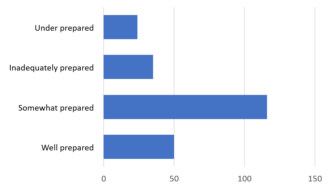
Responses to the survey question “When you entered the job market, how prepared did you feel to compete for a good job involving geospatial technologies?”

Slightly over half of respondents said they felt “somewhat prepared” to compete for a good job involving geospatial technologies when the entered the job market. More than a quarter felt “inadequately prepared” or “under prepared.” Only 22% of respondents felt they were “well prepared.” Is that good enough? Do graduates feel better prepared in some areas than others? 


The heart of the survey was three questions in which we asked YPNs to assess themselves against competencies specified in the Department of Labor’s Geospatial Technology Competency Model. For each of the three Industry Sectors – Positioning and Data Acquisition, Analysis and Modeling, and Software and App development – we asked respondents to rate themselves on five competencies. For each competency, respondents could choose “This topic doesn’t apply to me,” or “I didn’t know anything about this,” or “I didn’t know enough about this,” or “I understood this topic well.”

Questions 7, 8 and 9 asked YPNs to “Rate your knowledge and abilities at the time you earned your highest degree

in relation to [the three sectors of] Tier 5: Industry Sector Technical Competencies,  U.S. Department of Labor Geospatial Technology Competency Model.”

The four answer choices were associated with ordinal-level ranks, 1-4. For analysis, we summed all responses for each of the three Industry Sectors. The sums are depicted in the following graph as colored bars, where blue represents the Positioning and Data Acquisition sector, green is Analysis and Modeling, and Software and App Development is light orange.


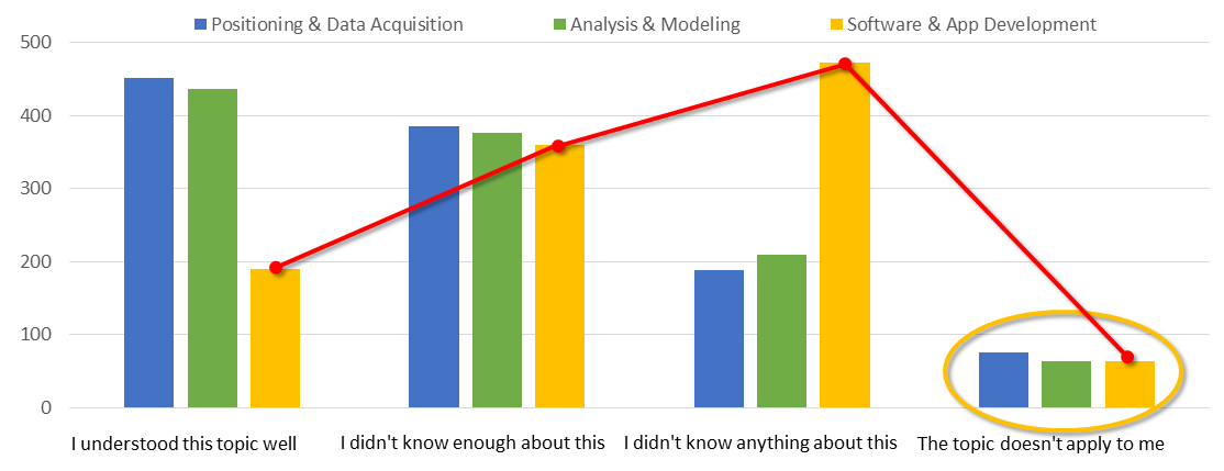
Responses to questions 7, 8 and 9, “Rate your knowledge and abilities at the time you earned your highest degree

in relation to [the three sectors of] Tier 5: Industry Sector Technical Competencies,  U.S. Department of Labor Geospatial Technology Competency Model.”

The first thing to note about these three distributions is that very few respondents indicated that any of the three sectors “doesn’t apply to me.” Ninety-four percent or more felt that competencies related to positioning and data acquisition, analysis and modeling, and software and app development are all relevant to their careers.


The second thing to note is that the distribution of responses is very similar for the first two sectors, Positioning and Data Acquisition and Analysis and Modeling. However, the distribution of competency ratings for Software and App Development is markedly different. Many fewer respondents stated that they “understood [those] topics well,” and many more said they “didn’t know anything about” the Software and App Development competencies. In fact, the difference between the distributions is highly statistically significant (Kolmogorov-Smirnov test, p = 0.00000009 and 0.00000002). The difference suggests a gap in graduates’ preparation in the knowledge and skills needed to be makers, rather than just users, of geospatial technologies. That’s troubling.


Finally, we invited respondents to offer advice to the GIS education community. 143 of our 226 (62%) respondents offered advice. The most common advice (41 comments) was to challenge students to code, to build models and apps, and to use up-to-date technologies.


“Make GIS harder.” One wrote. "Include more data science. More machine learning. More computer science. Programming ability should be heavily taught from day 1. Every class should use programming.”


Another advised, “Coding is such an important aspect of advanced geospatial analysis that it should be addressed in even basic classes.”


“The most important thing I wish I had learned as part of my undergrad GIS curriculum is basic programming/scripting, particularly with python and SQL,” another respondent observed.

Said another, “Define a curriculum that maintains the importance of Geography, yet incorporates GIS, scripting languages, and web development early and often in coursework.”

Thirty more respondents encouraged educators to create more realistic-as in applied and up-to-date- learning experiences for students.


“Make sure your students have a dose of the real-world before graduating.”


“They're going to need to approach things from a non-GIS point of view.  Find out what people are trying to accomplish and then talk with them about what GIS can deliver.”


“Get on the cutting edge more. Most classes are outdated”


“Design a course or degree like it's a real job from class 1. … GIS is not the normal way of doing things so neither should the study of it.”


So, what does Esri’s Education Outreach team conclude from these findings, and what do we advise? We recognize that curriculum design is a zero-sum game. New educational objectives and content can only be added to courses and certificate and degree programs at the expense of other objectives and content. And many educators have discovered that less rather that more content, and fewer rather than more objectives, often lead to better learning.

Still, we aim to help leading academic programs that seek to retool their curricula and infrastructure to align better with the trajectory of evolving GIS technology and professional practices. To that end, we’re establishing a “GIS Education Modernization” program that will:


·       Modernize education licensing to dispel real and perceived obstacles to adoption of more components of the ArcGIS platform, including ArcGIS Online, ArcGIS Pro, ArcGIS Enterprise, Insights for ArcGIS, and other related apps.


·       Add technical depth to our outreach team to better support educators who wish to engage students more deeply in coding, app building and IT-related experiences.


·       Provide concentrated outreach to the IS/MIS discipline to engage young scholars at the intersection of business and IT in the “Science of Where.”


·       Develop and promote modernized “straw man” curricula and other best practices through a monthly webinar program.


·       Expand and strengthen communication channels connecting our team with the GIS education community.


Our ultimate goal is to help willing education partners who wish to ensure that graduates enter the workforce with some level of competence in all three of the GTCM sectors: Positioning and Data Acquisition, Analysis and Modeling, and Software and App Development. Graduates are telling us, loud and clear, that two out of three is not good enough.

9 Comments
DanPatterson_Retired
MVP Emeritus

nice... might just make my convincing job easier

curtvprice
MVP Esteemed Contributor

Thanks for this.

I am getting a lot of pressure from my students for "a Python class." This is good inspiration to try putting a little bit in from the very beginning of our engineering school curriculum.  My school (I am an adjunct professor this year) has a very strong GIS track of classes but this is a great encouragement.

One issue is that one must teach students how to learn these technologies and the basic concepts behind building geoprocessing workflows -- the tech changes so darn fast something technical you teach a sophomore may be on its way out when they get out in the working world!  But the basic concepts of GP workflows have not changed since the old days, if you understand the fundamentals it makes it a lot easier to adapt to new technologies as they inevitably develop.

JoshuaBixby
MVP Esteemed Contributor

When it comes to being a GIS "professional," or at least a GIS practitioner, there are absolutely gaps between what students are learning and what skills are needed in the work place.  As mentioned, GIS is evolving "from a desktop-centric, standalone software product to a web-centric platform that’s increasingly integrated with mainstream information technology."  The vast majority of students I see graduating college have some grasp on traditional desktop GIS, but they have little understanding of the rest of the components involved with modern GIS.

I am a firm believer and advocate of "spatial isn't special," or at least not as special as it has been in the past.  GIS as a tool is becoming more commoditized or democratized, and spatial data is becoming more "just another data column/field" being collected, managed, and analyzed.

As powerful as a tool as GIS is, and it is, it is still just a tool for many specialists and business users.  In many ways, parts of the GIS software stack are going the route that business productivity went decades ago.  Being part of the geo-steno pool might be OK if you are in the sunset of your career, but the geo-steno pool won't last for graduates just entering the workforce today.

For GIS "professionals," the future is code and geography.  I agree withCurtis Price‌ that students need a solid foundation in concepts and theory.  Today, I think that means computer science and geography.  GUIs and wizards will always be around to help the specialists or business users, but as Brian Timoney has been saying for years about GIS professionals, "if your daily routine has you doing geospatial work strictly through GUI-driven desktop software, the impact on your future earnings is clear and unmistakable."

mrmark
by
Occasional Contributor

This is good information if what you need to do is convince higher ed faculty and administrators that they should be offering more programming, IT, and more "real-life" situations in the classroom. In my experience our faculty have been repeating these points like a broken record for at least a decade.

The real problem here is convincing the students that taking these classes is worth the effort when they get out. We have a strong GIS emphasis in our Geography department, however we find many students who officially follow one of the other emphases specifically to avoid the required programming courses. They tend to tune us out so we try to bring in former graduates working in the field to tell them these very things.

The other problem (at our institution - perhaps elsewhere) is that an increasing amount of weight is placed by administrators on student evaluations of courses. When lab exercises are specifically designed to be "real" the students rate the course lower because it was "unorganized" or because it was stressful not knowing exactly what was due when and how long it would take them to accomplish it, etc. The fact that the course evaluation questions asking about how much they learned were significantly higher than the average (department, college, & university) didn't save me from having to justify to certain administrators why the overall course rating was below average. Add that promotion & tenure decisions are tied predominantly to research output (fewer students asking questions outside of class the better...) and it is a tough sell to teach the students what they really need when all they want is a clear path to an A in the class.

In relation to Joshua's comments, it has been our experience over the past 5 years in particular that the students who do want all of these things as students are those that are NOT geography majors. They are coming from other majors with a problem in their discipline that they need to learn to use GIS to do. They already see what GIS can do for them, but it isn't their major.  

JoshuaBixby
MVP Esteemed Contributor

Mark, good feedback.  I have seen, or really heard, many of the issues you raise from faculty friends of mine.  Part of the problem is definitely the "business of higher education," and that business doesn't just impact GIS.

All of this gets back to some of the heartburn I have with GIS degrees or majors.  What should an employer really expect from a GIS major?  As you point out, the way that geographers view GIS is quite a bit different than other more technical disciplines.  Does it make more sense for a GIS major to minor in geography, computer science, environmental engineering, meteorology, etc..., or does it make more sense for a geography, computer science, environmental engineering, meteorology, etc.... major to minor in GIS?  Personally, I think the latter because the tools are always going to change but the foundations and theory of the respective fields will serve students for a lifetime.

mrmark
by
Occasional Contributor

All the faculty who teach GIS & Remote Sensing courses in our department are meeting this summer to try to make some major changes to the curriculum. Our trouble with GIS majors, is that when we require programming and IT on top of the GIS and DIP we are beyond what the university will allow for # of hours we can require. As a consequence, the students who are best prepared to "do GIS" don't have a body of subject knowledge to apply it to. The other side of the coin is that if we require courses to give them knowledge of some domain, the IT, programming, web design, etc. become electives, and very few take them.

At the end of the day I can't say which is "better" - the students who are passionate about something generally find a way to succeed. I think there is a place for both models you talk about. I worry a bit more about people who are a biology major (for example) who take a GIS course and come away thinking that being able to make a map using ArcGIS Online makes them a GIS guru. It may just be my bias as a Geographer, but I think people who have the "full stack" of GIS skills includes the ability to work with experts in any domain and put together the appropriate GIS/RS/IT tools and procedures to answer their questions/solve their problems. 

BillChappell
Occasional Contributor II

As a GIS consultant and Developer I've taught as an Esri Authorized instructor for 10 years and as Adj Fac at a university for 14 years. The commercial classes were more rewarding to teach as the students saw the need for the class. They could apply the skills taught the next day and it solved some of their problems.

The colleges students see it as a 3 credit check box on the path of a degree. They know it's required but it's just another course. Many don't know what GIS is when they sign up. I found In the intro class just finding the file they downloaded and trying to unzip it is almost a full class. Those who take the python and JavaScript web mapping in the advanced course, remark if they wanted a programming class they would have taken Computer Science. 

Some of this falls on the department as it's tough to make a Geography or Envi science program cross over to the computer science department for a database class or a intro to programming class. Not to mention many Computer Science departments don't teach python.

While in my Intro classes I try to bring in real world examples, talking to their other professors I try to show a problem they recently were taught and break it down with GIS. This gets some interest but only from students in that department. I also teach a lecture on python, with most of it as a lab, so they are exposed to it.  I include a demo of the Leaflet JS site and a simple map to show them their is more then the desktop. 

In the end, most of it is the students, this year I was able to create an internship with the school for assisting with GIS development at the facilities management office,  3 credits and a $2,000 stipend for about 130 hours of work. No one was interested, too busy. 

JoshuaBixby
MVP Esteemed Contributor

Thanks for sharing Bill.  Besides the "business of education" putting up obstacles, I think the silos in academia also create obstacles.  GIS is fundamentally a cross discipline tool or concept, and collaboration is difficult whether one is in government, academia, or the private sector.

daveostrander
Occasional Contributor II

Great article!!! This has been a sore spot in our field for sometime, and getting to the root of it in a single degree program is not exactly easy, or for that matter cut and dry. We are essentially talking about how to package two distinct fields, computer science and geography, into one. Unfortunately, both fields are extensive, and attempting a kitchen sink approach could lead to poor coverage overall. I think the hard reality we all need to accept as modern day GIS professionals is to stay hungry, and commit to being life-long learners. Honestly, the technology requires this anyway. I am not arguing against a healthy dose of computer science in geography curriculum, instead I am advocating that we all be a bit more realistic.

I think a great idea that university geography programs could adopt is the notion of nano degrees for GIS development tracks. Package up 3 to 5 courses specializing in various GIS development functional areas (i.e. big data specialization, web development, GIS tool/software creation), and offer them as ancillary certificate type programs. That way students will start with a more traditional style graduate program that includes some of the computer science elements (i.e. a GIS based python course, introductory cloud computing, or intro to using an API), and then can optionally go back for a nano degree that specializes in building on those skills. I think this approach would go a long way to providing students the deserved time and attention these skills require to learn. If done correctly I am willing to bet that the future outcomes of this survey would render vastly different results.

UW-Madison has an online M.S. degree geared toward GIS and web map programming. That is a good start, but for someone who already has a MGIS degree it is still a tough sell. Hopefully in the near future they, or institutions like them, will break that MS degree down into a slew of bite sized post-grad GIS nano degrees.

About the Author
Education Sector lead | Global Business Development Sr. Lecturer | Penn State University B.S. and M.S. Cartography, University of Wisconsin–Madison GISP, CMS